New Matrice 4T and Matrice 4E enterprise drones feature smart detection for Smarter Operations and Laser Range Finder for Real-Time Precise Measurement
Virtual Surveyor Adds Productivity Tools to Mid-Level Smart Drone Surveying Software Plan

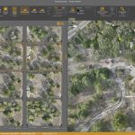
Create Surveys Faster at the Same Cost
Nokia and Swisscom Broadcast to deploy largest Drones-as-a-Service network

Nokia Drone Networks solution including 300 Drone-in-a-Box units, will enhance safety and operational efficiency for public safety and industrial use cases in Switzerland. Collaboration with Swisscom Broadcast will also enable the advancement of industrial use cases, drone automation, beyond visual line of sight (BVLOS) operations, and the expansion of 3GPP technologies for drone use in […]
Virtual Surveyor Unveils Photogrammetry App in Major New Release of Smart Drone Survey Software
Seamless Drone Surveying Workflow
SPH Engineering Sets a New Standard for Drone Shows with the Latest Drone Show Technologies Updates

August 2, 2023 – Riga, Latvia – SPH Engineering, a leading provider of cutting-edge drone solutions, is thrilled to announce the release of three major updates – the Newest Drone Show Software v.4.2, Firmware v. 4.2, and Drone Show Creator updates. These updates bring an array of powerful features that will elevate the world of […]
SimActive Announces New Pricing for Larger Drone Cameras

Montreal, Canada, July 18th., 2023 – SimActive Inc., a world-leading developer of photogrammetry software, announces new pricing for its Correlator3D software. Larger drone cameras of up to 61 megapixels are now covered under the low-priced UAV license option, which was previously capped at 50MP.
Liverpool welcomes Eurovision with record-breaking drone show by Celestial and Drone show Technology

Liverpool’s Eurovision Song Contest 2023 Opening Ceremony was marked by the largest single-location drone show in the UK to date, featuring 624 drones flown by Celestial as part of the National Lottery’s Big Eurovision Welcome. Over 40,000 people witnessed the 90-minute concert at St George’s Hall featuring performances from music legends like The Lightning Seeds, […]
Esri Partner Pollen Systems Provides Advanced Agriculture Analytics to Farms using PrecisionView™ Mobile
Mapping aerial imagery captured by drones and satellites together with mobile data helps farms deliver better crop yield and quality.
Draganfly Fulfills Delivery of First Situational Assessment Drone for DSNS Emergency Services Department Ukraine
Draganfly’s Situational Assessment Drones will provide regions of Ukraine with intel, infrastructure assessments, and aid in search and rescue operations throughout the country.
TOPODRONE synchronized LiDAR and bathymetric surveying methods to study a floating solar farm in Israel
January 12, 2023 – Montreux, Switzerland – TOPODRONE, a Swiss based designer and manufacturer of high-precision surveying equipment, has synchronized airborne photogrammetry, and LiDAR and bathymetric surveying methods which was used to study a floating solar farm.