Port St. Joe-Wewahitchka, Florida, Jan. 09, 2023 (GLOBE NEWSWIRE) — UAV Corp’s (OTC Pink: UMAV) Skyborne Technology receives building permit from Gulf County, Florida for the build of the largest drone hangar in the State of Florida. Further, from the awarded $1,104,868 million in Grant funding for the infrastructure for water, sewer, power, and road […]
American Dronemaker Skydio Asserts Docked Drone Leadership
Bringing the crucial ingredient of trustworthy autonomy to the drone-in-a-box market
Global Military Unmanned Aerial Vehicle Market Report to 2032
Global Military Unmanned Aerial Vehicle Market Report to 2032 – Featuring AeroVironment, Aeronautics, Elbit Systems and Northrop Grumman Among Others – ResearchAndMarkets.com
Hexagon’s Leica BLK2FLY named one of TIME’s Best Inventions of 2022

Hexagon AB, a global leader in digital reality solutions combining sensor, software and autonomous technologies, today announced the Leica BLK2FLY has been named one of TIME’s Best Inventions of 2022.
SmartDrone Unveils its Latest Mapping Drone: Discovery 2
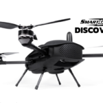
Join the live AMA to hear how the new drone is augmenting traditional earth measuring.
Mobilicom’s Skyhopper Combo Selected by Israeli Ministry of Defense for Drone Fleet
Shoham, Israel, Oct. 25, 2022 (GLOBE NEWSWIRE) — Mobilicom Limited (Mobilicom or the Company, NASDAQ: MOB, MOBBW, ASX: MOB), a provider of cybersecurity and smart solutions for drones, robotics, and autonomous platforms, has received and fulfilled an initial SkyHopper COMBO order for an existing Tier-1 customer, Israel Ministry of Defense (IMOD), for a new fleet deployment program designed by a […]
Announcing EagleView Assess Autonomous Drone-Sourced Property Intelligence
EagleView’s gold standard in roof data – no matter who is flying
VERSES Enables Autonomous Drone Crowd Safety Monitoring Missions in Zaragoza, Spain
COSM artificial intelligence operating system, geospatial digital infrastructure and drone mobility portal deployed during the 2022 Pilar Festivities
Mobilicom Launches New Product Enabling Mass Deployment of Small Drone Fleets
Shoham, Israel, Oct. 20, 2022 (GLOBE NEWSWIRE) — Mobilicom Limited (Mobilicom or the Company, NASDAQ: MOB, MOBBW, ASX: MOB), a provider of cybersecurity and smart solutions for drones, robotics, and autonomous platforms, has broadened its SkyHopper range with the launch of a new micro bi-directional data link specifically designed to enable mass deployment of small drone fleets.
MissionGO Signs 3-Year, $50 Million UAS Infrastructure Inspection Partnership with Southern California Edison
BALTIMORE, Md., Oct. 20, 2022 (GLOBE NEWSWIRE) — MissionGO Unmanned Systems, a leader in uncrewed aircraft systems (UAS) production and operations announced a 3-year partnership providing UAS inspection services to Southern California Edison, the largest subsidiary of Edison International and primary electricity supply company for much of Southern California.