WorldView-4 Imagery To Become Available To All Commercial Customers On August 31
Imagery, earth imaging and remote sensing
Remote GeoSystems Donates LineVision Software to Official Drone Operators for Hurricane Harvey and Irma Response and Assessment

FORT COLLINS, Colorado/FORT BEND COUNTY, Texas – To assist with Hurricane Harvey and Irma emergency response and damage assessments efforts, Remote GeoSystems, Inc. is pleased to announce the donation and free availability of LineVision™ softwarelicenses to official agency, volunteer and non-profit drone operators.
Panoramic Imagery for Canyon Gate Subdivision, Fort Bend County, Texas

An update from Fort Bend County, Texas and their recent use of Esri Startup company, GroundVu, for obtaining 3D imagery of flood areas.
NASA Sees Irma Strengthen to a Category 5 Hurricane

NASA and NOAA satellites have been providing valuable satellite imagery to forecasters at the National Hurricane Center, and revealed that Hurricane Irma has strengthened to a Category 5 hurricane on Sept. 5 around 8 a.m. EDT (1200 UTC).
High-Resolution Flood Imagery on Website, App Today to Assist Houston Relief Efforts

The before-and-after imagery slider on Woolpert’s website allows local, state and federal officials and the public to navigate and enhance sites in Houston in the wake of Hurricane Harvey.
Sentinel-5 Precursor begins final journey to launch site
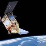
Stevenage, 30/08/2017 – Europe’s pollution monitoring satellite Sentinel-5 Precursor has left Airbus’ Stevenage site and is on its way to the launch site, the Plesetsk Cosmodrome in Russia. Launch is currently planned on 9 October on aRockot rocket.
DigitalGlobe Satellite Imagery: Hurricane Harvey Before/After

On Friday evening, August 25, Hurricane Harvey slammed into the Gulf Coast of Texas, just southwest of Houston. The hurricane packed sustained winds in excess of 130 miles per hour, and has since been identified as the largest single rainmaking event in Continental U.S. history, with totals in some areas exceeding 50”.
SPOT 6/7 imagery to feed Satshot’s mapping platforms for improved efficiency of US agriculture
Chantilly, VA, 28 August 2017 – Airbus Defence and Space has entered into an agreement with the GIS mapping engine operator Satshot to provide high-resolution SPOT 6/7 satellite data over a large area of the corn and wheat belt within the continental United States. SPOT 6/7 data is integrated into the Satshot platform, which can be used for deep […]
Solar Orbiter on track to launch before next total solar eclipse
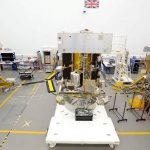
Airbus’ Solar Orbiter in the final stages of integration in Stevenage, UK, and ready for full system electrical testing. By next eclipse it will be en route to its close-up encounter with our sun!
EarthCam Broadcasts Total Solar Eclipse in Nashville
Today, for the first time, EarthCam’s live webcams followed the totality of the solar eclipse throughout the United States. EarthCam traveled to the heart of Nashville, TN to broadcast the historic event, where the solar eclipse was visible at 100% obscuration. EarthCam compiled this exclusive footage and is sharing for everyone to enjoy.