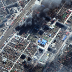
New Maxar satellite imagery (March 18-21, 2022) reveals continued Russian military activity in and around a number of key Ukrainian cities including Mariupol, Kyiv, and Chernihiv.
Esri Recognizes Partners for Innovation and Excellence

Awards Granted for Exceptional Achievement Using GIS at Esri Partner Conference
New Esri Book Helps Public Safety Agencies Get Started with GIS Technology

Smart Maps, Dashboards, and Location Data Analysis Have Become Mission-Critical Tools
OGC Publishes Best Practice for Earth Observation Application Packages

The document outlines the implementation, packaging, and deployment of cross-cloud EO Applications – A step forward for greater efficiency and bringing the ‘user to the data.’
GEOINT 2022 Innovative Tradecraft Competition – Entries Open January 12

First Round: Wednesday, March 16, 0830-1600 – USGIF Trajectory Event Center, 13665 Dulles Technology Dr. Suite 150, Herndon, VA and via Webinar
New Esri Book Provides Beginners a Guide for Location Analytics
Getting to Know ArcGIS Pro 2.8 Shows New Users How to Make Sense of Data with GIS
Looking to the Future of American Cities, USCM Launches New Task Force on Electric Vehicles

WASHINGTON, Dec. 23, 2021 — Today, U.S. Conference of Mayors (USCM) President Dayton (OH) Mayor Nan Whaley announced the formation of a new Conference Task Force on Electric Vehicles, reflecting the rising importance of EVs in mayors’ plans for modernizing transportation systems.
Parrot ANAFI Ai, the first 4G connected robotic UAV is ready for work.

Parrot ANAFI Ai starts shipping in January.
NGA Accelerator Seeks Third Cohort of Geospatial Technology Companies

NGA Accelerator will accept applications until Jan. 18 for its third cohort.
Maxar Satellite Imagery: Flooding Along Fraser River, British Columbia
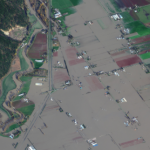
Maxar collected new satellite imagery on Friday (November 19th) of the ongoing flooding in Sumas Prairie to the east of Abbotsford, British Columbia, Canada. Highways, roads and many buildings and farms remain under water.