GIS user technology news

News, Business, AI, Technology, IOS, Android, Google, Mobile, GIS, Crypto Currency, Economics

  • Advertising & Sponsored Posts
    • Advertising & Sponsored Posts
    • Submit Press
  • PRESS
    • Submit PR
    • Top Press
    • Business
    • Software
    • Hardware
    • UAV News
    • Mobile Technology
  • FEATURES
    • Around the Web
    • Social Media Features
    • EXPERTS & Guests
    • Tips
    • Infographics
  • Blog
  • Events
  • Shop
  • Tradepubs
  • CAREERS
You are here: Home / * PRESS / Earth Imaging - Remote Sensing / Satellite Imagery of Suez Canal and Stuck Container Ship @Maxar

Satellite Imagery of Suez Canal and Stuck Container Ship @Maxar

March 26, 2021 By Editor

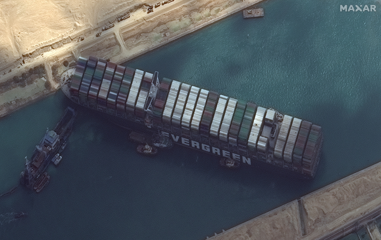
Maxar’s WorldView-2 collected new high-resolution satellite imagery this morning (March 26th) of the Suez canal and the container ship (EVER GIVEN)–a 1,300-foot ship operated by the Taiwan-based Evergreen Group–that remains stuck in the canal north of the city of Suez, Egypt. In today’s satellite imagery, multiple tug boats are positioned alongside the ship and dredging operations are in progress trying to help remove sand from around the ship and help refloat it.

Satellite image ©2021 Maxar Technologies


Filed Under: Earth Imaging - Remote Sensing, Top Press Tagged With: Imagery, maxar

Editor’s Picks

jack dangermond

First Look – Los Angeles Opens the GeoHub – #OpenData for Citizens and Developers

Safe Software WEBINAR – Geospatial and Minecraft – Why You Should Care

HxGN LIVE 2015 – Great Stories Continue with the Hexagon Geosystems Track

Apple Unveils All-New MacBook – The Notebook Reinvented

See More Editor's Picks...

About Editor

Glenn is a geographer and a GIS professional with over 20 years experience in the industry. He's the co-founder of GISuser and several other technology web publications.

Recent Industry News

The Drift Between Early Notes and Final Case Files in Abuse-Related Legal Support

April 29, 2026 By GISuser

Aerial Surveys Int’l and Global Marketing Insights to Present GEOINT 2026 Workshop on Multi-Domain Geospatial Fusion for Automated Infrastructure Monitoring

April 24, 2026 By GISuser

Why Timing Matters More Than You Think With Spray Seal (And Why People Often Get It Slightly Wrong)

April 22, 2026 By GISuser

The Quiet Planning Stage Most People Don’t See When Building a Pool in Brisbane

April 22, 2026 By GISuser

Hot News

State of Data Science Report – AI and Open Source at Work

HERE and AWS Collaborate on New HERE AI Mapping Solutions

Virtual Surveyor Adds Productivity Tools to Mid-Level Smart Drone Surveying Software Plan

Categories

Copyright gletham Communications 2015 - 2026

Go to mobile version