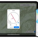
Touch GIS has introduced a digital clinometer tool to assist field geologist in recording strike & dip readings. Version 1.3 of the app also features a new ‘Attitude’ attribute type, which makes it easy to record and display these readings on the map.
You are here: Home / Archives for Touch GIS