GIS user technology news

News, Business, AI, Technology, IOS, Android, Google, Mobile, GIS, Crypto Currency, Economics

  • Advertising & Sponsored Posts
    • Advertising & Sponsored Posts
    • Submit Press
  • PRESS
    • Submit PR
    • Top Press
    • Business
    • Software
    • Hardware
    • UAV News
    • Mobile Technology
  • FEATURES
    • Around the Web
    • Social Media Features
    • EXPERTS & Guests
    • Tips
    • Infographics
  • Blog
  • Events
  • Shop
  • Tradepubs
  • CAREERS
You are here: Home / Archives for California

Betterview Announces Engagement with NFPA to Provide Property and Community-Level Wildfire Insights

August 8, 2022 By GISuser

SAN FRANCISCO, Aug. 08, 2022 (GLOBE NEWSWIRE) — Betterview is pleased to announce a new relationship with the National Fire Protection Association® (NFPA®), a non-profit organization devoted to eliminating death, injury, property, and economic loss due to fire, electrical, and related hazards, focused on helping insurers in California adhere to the state’s pending “Safer from Wildfire” legislation and […]

Filed Under: Business Tagged With: California, wildfire

Maxar Satellite Imagery: Caldor Fire Approaching Lake Tahoe

September 1, 2021 By GISuser

Maxar continues to monitor the Caldor wildfire as it approaches the southern edge of Lake Tahoe along the California-Nevada border.  Maxar collected yesterday (August 31st) that shows closer views of South Lake Tahoe, the active fire lines and a large pyrocumulus cloud formed by the intense fire.

Filed Under: Earth Imaging - Remote Sensing, Emergency Response, Top Press Tagged With: California, maxar, wildfire

Maxar Satellite Imagery: Dixie Fire, California

August 10, 2021 By GISuser

Maxar collected new satellite images on Sunday, August 8th of northern California and the Dixie wildfire that continues to burn and has become the state’s second largest wildfire in history.

Filed Under: Earth Imaging - Remote Sensing, Environment Tagged With: California, Imagery, maxar, wildfire

Satellite Imagery @Maxar : Southern California’s Blue Ridge and Silverado Wildfires

October 29, 2020 By Editor

Maxar Technologies collected new satellite imagery yesterday (October 28th) of the Blue Ridge and Silverado Wildfires that rapidly spread over the past couple of days in southern California, threatening multiple cities including Yorba Linda, Chino Hills and Irvine, California.

Filed Under: Earth Imaging - Remote Sensing, Emergency Response, Environment, Featured TOP PR Tagged With: California, Imagery, maxar, wildfire

Animated Map Highlights 10 Most Destructive Wildfires in California History

October 15, 2020 By Editor

10 Most Destructive Wildfires in California History

Animated Map Highlights 10 Most Destructive Wildfires in California History. The new map from Esri highlights wildfires that claimed the most lives and destroyed the most structures. 

Filed Under: Emergency Response, Maps and Cartography, Top Text Lead Story Tagged With: California, ESRI, Video, wildfire

Maxar Satellite Imagery: Bobcat Wildfire, Northeast of Los Angeles

September 23, 2020 By Editor

Maxar Technologies’ WorldView-3 satellite collected new images September 21 of the large Bobcat Fire burning northeast of Los Angeles, California.

Filed Under: Earth Imaging - Remote Sensing, Emergency Response, Featured TOP PR Tagged With: California, maxar, wildfire

Squadron of Private Planes from California Airlifts Medical Aid to Fire-Ravaged Oregon

September 21, 2020 By Editor

A flying armada organized by volunteer pilots flying private aircraft today delivered 100,000 KN95 respirators from Direct Relief’s California-based humanitarian distribution center to residents and firefighters in Oregon’s worst-hit fire-zones.

Filed Under: Business, Emergency Response, Featured TOP PR Tagged With: California, Oregon, wildfire

Satellite Imagery: August Complex Fires, California

September 14, 2020 By Editor

Maxar Technologies captured today (September 14) collected a set of satellite images of the August Complex wildfire, burning to the west of Chico, California and near the northern California coast.

Filed Under: Business, Earth Imaging - Remote Sensing, Emergency Response, Featured TOP PR Tagged With: California, Imagery, maxar, wildfire

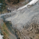
Satellite Imagery: LNU Lightning Wildfire in California via Maxar

August 21, 2020 By GISuser

Lnu lightning complex wildfire_healdsburg california_20august2020_wv3 shortwave infrared image

Maxar’s WorldView-3 satellite collected new imagery yesterday afternoon (August 20th) of the LNU Lightning Complex wildfire burning in Sonoma County near Healdsburg, California.

Filed Under: Earth Imaging - Remote Sensing, Emergency Response, Top Text Lead Story Tagged With: California, Imagery, maxar, wildfire

GIC Collects Imagery over Kincade Fire in Sonoma County

November 1, 2019 By GISuser

38°38'31.6"N 122°45'09.9"W 128, Calistoga, CA 94515 LEAPNOW: Transforming Education

IMAGES AVAILABLE TO EMERGENCY PERSONNEL, GIC MEMBER INSURERS, AND THE MEDIA

Filed Under: Emergency Response, Environment Tagged With: California, Imagery, wildfire

« Previous Page
Next Page »

Recent Industry News

Best Equipment Labels for Industrial Use: Ranked Systems That Survive Real-World Conditions

April 17, 2026 By GISuser

Building a Global Natural Brand: The Digital Journey of VedaOils

April 15, 2026 By GISuser

DeltaQuad partners with Meridein Group OÜ to strengthen UAS capability in the Baltics

April 15, 2026 By GISuser

The Complete Guide to Improving Home Safety and Efficiency with Dryer Vent Cleaning

April 12, 2026 By GISuser

Hot News

State of Data Science Report – AI and Open Source at Work

HERE and AWS Collaborate on New HERE AI Mapping Solutions

Virtual Surveyor Adds Productivity Tools to Mid-Level Smart Drone Surveying Software Plan

Categories

Copyright gletham Communications 2015 - 2026

Go to mobile version