GIS user technology news

News, Business, AI, Technology, IOS, Android, Google, Mobile, GIS, Crypto Currency, Economics

  • Advertising & Sponsored Posts
    • Advertising & Sponsored Posts
    • Submit Press
  • PRESS
    • Submit PR
    • Top Press
    • Business
    • Software
    • Hardware
    • UAV News
    • Mobile Technology
  • FEATURES
    • Around the Web
    • Social Media Features
    • EXPERTS & Guests
    • Tips
    • Infographics
  • Blog
  • Events
  • Shop
  • Tradepubs
  • CAREERS
You are here: Home / Archives for api

Everything You Need to Know About eSignatures: API, Solutions, and Pricing 

January 21, 2025 By GISuser

Application Programming Interfaces (APIs) are the backbone of modern eSignature solutions. eSignature API  allows businesses to seamlessly integrate eSignature functionalities into their existing systems, such as CRMs, ERPs, and HR platforms. 

Filed Under: Around the Web Tagged With: about, AND, api, around, esignatures:, everything, know, need?, pricing, solutions, the, web, you

The Best Stock Market API for Your Investment Needs

December 9, 2024 By GISuser

Choosing the best stock market API is like finding a needle in a haystack, full of complexities and potential pitfalls. You’ve got to think about data accuracy, real-time updates, and robust security measures. But with so many options, like Alpha Vantage and Finnhub, how do you really know which one aligns perfectly with your investment […]

Filed Under: Around the Web Tagged With: api, around, best, for, investment, market, needs, stock, the, web, your

4 Key Benefits of API Integration Services for Streamlining Business Operations

July 31, 2024 By GISuser

Photo from pexels In the current digital era, companies are depending more and more on technology to improve client experiences, increase productivity, and simplify processes. An extremely potent instrument in this technical arsenal is the integration of APIs or application programming interfaces. API integration services provide communication across various software programs, allowing for easy feature […]

Filed Under: Around the Web Tagged With: api, around, benefits, business:, for, integration, key, Operations, Services, streamlining, the, web

Copper Pulse: Reacting Swiftly to Real-Time Prices with API Insights

June 14, 2024 By GISuser

For trading commodities like copper, where prices are intricately tied to global economic shifts, geopolitical tensions, and supply-demand imbalances, even the slightest delay in reacting to market movements can have profound consequences for investors. Real-time access to accurate and comprehensive market data is, therefore, indispensable for navigating these turbulent waters with confidence and agility.

Filed Under: Around the Web Tagged With: api, around, copper, insights, prices?, pulse, reacting, real-time, swiftly, the, web, with

How APIs Connect Applications to Enable More Powerful Geospatial Analysis
November 6, 2020 By Editor

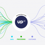
APIs connect UP42, geospatial data and processing capabilities, and the applications built with those

UP42’s Approach to APIs – By Linda Duffy

Filed Under: Around the Web, Developer, EXPERTS, Top Press Tagged With: api, developer, UP42

OGC announces candidate OGC API – Features – Part 2 standard; public comment requested

February 28, 2020 By GISuser

28 February 2020: The Open Geospatial Consortium (OGC) seeks public comment on the OGC API – Features – Part 2: Coordinate Reference Systems candidate standard.

Filed Under: Business Tagged With: api, OGC

Polte IoT Cloud Now Available on AWS Marketplace

December 2, 2019 By Editor

Polte receives exclusive invite to demo the company’s geolocation API in the AWS Partner Solutions Experience at AWS re:Invent

Filed Under: Business Tagged With: api, aws

AND (AMS:AND) Launches New Suite of API for Location Aware Content

September 3, 2019 By GISuser

AND’s location-aware data such as digital maps, global admin boundaries, ZIP+4 information and new innovative AND content will increasingly be available via APIs.

Filed Under: DATA, Developer Tagged With: AND, api

OGC is seeking information on Geospatial APIs

March 20, 2017 By GISuser

8 March 2017: The Open Geospatial Consortium (OGC®) is looking for information on the existence of mapping and geospatial Application Programming Interfaces (APIs) as part of an OGC Concept Development Study (CDS) that will examine the interoperability of existing geospatial APIs.

Filed Under: Business Tagged With: api

Esri Helps Developers Add Geo to Apps at TechCrunch Disrupt NY 2016

May 6, 2016 By GISuser

Online services, APIs, SDKs, and ready-to-use content available through the Esri Startup Program

Filed Under: Business, Developer, FrontPage Leader, Top Text Lead Story Tagged With: api, developer, ESRI, New York, tcdisrupt

Next Page »

Top Press

The Global Expansion of Aueshah: A New Era of High Jewelry

April 11, 2026 By GISuser

KARACHI, PAKISTAN. The international luxury market is experiencing a profound shift. Consumers are increasingly rejecting mass-produced goods in favor of rarity, authenticity, and emotional depth. … [Read More...]

State of Data Science Report – AI and Open Source at Work

September 10, 2025 By GISuser

AI and Open Source at Work … [Read More...]

Topcon Announces Landmark Expansion of Topnet Live Network Across USA

January 26, 2025 By GISuser

LIVERMORE, Calif.---Topcon Positioning Systems has announced a significant expansion of its Topnet Live reference station network, introducing 200 new geodetic stations strategically positioned across … [Read More...]

Space Flight Laboratory (SFL) Announces Launch and Deployment of NorSat-4 Maritime Monitoring Microsatellite

January 19, 2025 By GISuser

Seventh Satellite Developed by SFL for Norway … [Read More...]

HERE and BMW Group extend partnership on AI-powered mapping system

January 8, 2025 By GISuser

HERE and BMW Group extend partnership on AI-powered mapping system for automated driving and enhanced road safety … [Read More...]

SFL Missions Inc. Confirms Successful Deployment of Six HawkEye 360 Radio Frequency Detection Satellites with Advanced Capabilities

October 27, 2026 By GISuser

MĀHIA, New Zealand, 26 October 2026 – SFL Missions Inc. today confirmed the successful deployment of six radio frequency (RF) detection and geolocation satellites for HawkEye 360 … [Read More...]

Canadian-Built RoadEng 12 Uses AI to Find the Best Location for New Resource and Rural Roads

October 17, 2026 By GISuser

Vancouver, BC, Canada, October 15, 2026 – North Vancouver-based Softree Technical Systems today released RoadEng Version 12, used in more than 75 countries to locate and design … [Read More...]

Beyond the Map: How AI Image and Video Generation Is Changing Geospatial Communication

October 14, 2026 By GISuser

Ask anyone who has shipped a GIS project what the hardest part was, and the answer is rarely the spatial analysis. It is almost always the communication. A site suitability … [Read More...]

From Maternity to Everyday Wear: Building a Wardrobe That Grows With You

October 14, 2026 By GISuser

When I think about maternity clothing, I feel the biggest mistake is buying too many things at once. During pregnancy, your body keeps changing, and something that fits well today … [Read More...]

eMMC 5.1 Explained: Features, Performance, and Applications in Modern Devices

October 14, 2026 By GISuser

Storage technology is an essential part of modern computing, influencing how devices store information, launch applications, and manage everyday workloads. Although … [Read More...]

Copyright gletham Communications 2015 - 2026

Go to mobile version