
OMAHA, NE)— As travelers seek out more authentic ways to connect with people and places, the Lewis & Clark National Historic Trail unveils the ultimate online trip-planning portal, lewisandclark.travel. The portal, which is designed to help visitors learn more about the host communities, local businesses, and attractions located along the 4,900-mile trail which runs from Pittsburgh, Pennsylvania, to the […]
Complimentary World LNG Map at Gastech 2021 and World Gas Conference (WGC 2022) by Mudrock Media

KUALA LUMPUR, Malaysia–Mudrock Media will present at Gastech 2021 exhibition, the first major energy event to take place live & in-person from September 21-23, 2021 at Dubai World Trade Centre, United Arab Emirates, and the 28th World Gas Conference (WGC2022) from May 23-27, 2022 in Daegu, South Korea. Mudrock Media will hand out 3,000 complimentary […]
Clear Seas Launches Interactive Mapping Dashboard That Visualizes Marine Shipping Safety in Canada

VANCOUVER, British Columbia–An online dashboard developed by the Clear Seas Centre for Responsible Marine Shipping (Clear Seas) provides a comprehensive, first-of-its-kind publicly available picture of marine shipping incidents and accidents in and around Canadian waters.
Esri Releases New 2020 Global Land Cover Map

Project Joins Startup Impact Observatory and Microsoft to Deliver Map to Worldwide Users
New Interactive App Visualizes 14 Months of Unemployment Data by State, County

REDLANDS, Calif.–(BUSINESS WIRE)–Esri, the global leader in location intelligence, announced today that UnemploymentPulse, a new app built with ArcGIS Platform, lets you explore 14 months of unemployment data from the Bureau of Labor Statistics as spark lines in each state and county against the national average. Inspired by the COVIDPulse app, this mapping app lets you compare the […]
British Red Cross turns to digital mapping to help meet increased demand for support due to Covid-19

18 May 2021 – The British Red Cross has created new mapping tools using Esri GIS, which are being used by the Voluntary and Community Sector Emergencies Partnership (VCSEP) and its network of over 250 organisations, to improve collaboration as it responds to the Covid-19 crisis.
MapBusinessOnline Issues USA Map Update of COVID-19 Vaccination Progress

CORNISH, Maine, March 23, 2021 /PRNewswire/ — SpatialTEQ Inc., publisher of North America’s most advanced business mapping software www.MapBusinessOnline.com, announces today the publications of a MapBusinessOnline daily update map of the USA’s COVID-19 full-vaccination progress.
I Got Vaccinated! Story Map Shares the Who & Where of #COVID-19 Vaccinations

A good story(map) story tip via our friend Joseph Kerski of Esri… “Our health team at Esri worked with GISCorps who is hosting this application where people can share their vaccination stories and approving submissions.”
CoronavirusOutbreakMap.com COVID-19 Memorial Honoring Those Dead From COVID-19
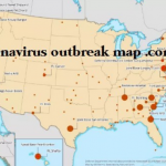
NEW YORK, Nov. 25, 2020 — With the millions of people that have died from COVID-19, CoronavirusOutbreakMap.com is honoring everyone that has died from COVID-19.
Aspectum visualizes and analyzes maritime connections between the Philippine central islands

Aspectum has created a map analyzing and visualizing maritime connections between the Philippine central islands – Region IV (Calabarzon & Mimaropa), Region VI (Western Visayas), and NCR (National Capital Region). Vessel movement trajectory was built into routes based on Automatic Identification System (AIS) data. AIS connects transponders from each ship above 300 gross tonnage and […]