GIS user technology news

News, Business, AI, Technology, IOS, Android, Google, Mobile, GIS, Crypto Currency, Economics

  • Advertising & Sponsored Posts
    • Advertising & Sponsored Posts
    • Submit Press
  • PRESS
    • Submit PR
    • Top Press
    • Business
    • Software
    • Hardware
    • UAV News
    • Mobile Technology
  • FEATURES
    • Around the Web
    • Social Media Features
    • EXPERTS & Guests
    • Tips
    • Infographics
  • Blog
  • Events
  • Shop
  • Tradepubs
  • CAREERS
You are here: Home / Archives for * PRESS / Government & OpenGov

Esri Tech to Help Modernize Vermont Department of Taxes

August 17, 2020 By GISuser

Esri Partner Axiomatic Will Design Solutions to Promote Fair and Equitable Taxation

Filed Under: Business, Government & OpenGov Tagged With: ESRI, OpenGov

Esri and United Nations Create COVID-19 Population Vulnerability Dashboard

July 28, 2020 By GISuser

New Tool Will Help Public Health Organizations Use Census Data to Fight Pandemic

Filed Under: Emergency Response, Government & OpenGov, Top Text Lead Story Tagged With: COVID-19, dashboard, ESRI, UN

NEVS launches PONS – the first mobility ecosystem with autonomous vehicles for city needs

July 1, 2020 By GISuser

The self-driving vehicle Sango is the centrepiece of the system

NEVS presents its new mobility ecosystem: PONS – the first generation of autonomous vehicles with a connected user interface – which could become the mobility solution for smart and sustainable cities. The self-driving vehicle Sango is the centrepiece of the system.

Filed Under: Business, Government & OpenGov Tagged With: Smart City

Saudi Arabia Launches COVID-19 Dashboard Using Esri Technology

June 19, 2020 By GISuser

The Country’s Ministry of Health Is Tracking Pandemic Cases with New GIS Resources

Filed Under: Business, Government & OpenGov, Maps and Cartography Tagged With: COVID-19 Dashboard

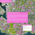
Map of pavement widths helps local authorities with social distancing plans

June 5, 2020 By GISuser

Analysis reveals 70% of pavements are not wide enough for social distancing

Analysis reveals 70% of pavements are not wide enough for social distancing

Filed Under: Business, DATA, Emergency Response, Government & OpenGov, Top Press, Top Text Lead Story Tagged With: coronavirus, ESRI, esri uk

Commerce Department Releases New Regulations to Support U.S. Leadership in Commercial Satellite Remote Sensing Industry

May 20, 2020 By GISuser

Today, the U.S. Department of Commerce released new regulations to improve the licensing process for private U.S. satellite remote sensing operations, helping ensure continued U.S. leadership in a critical commercial space industry.

Filed Under: DATA, Earth Imaging - Remote Sensing, Government & OpenGov

South Carolina Legislature, Mass. Secretary of State, NJ United, and Mississippi Planning and Development District Select Maptitude for Redistricting

April 17, 2020 By GISuser

NEWTON, MASSACHUSETTS (USA) – Caliper Corporation is pleased to announce that four more organizations have selected Maptitude for Redistricting. The South Carolina Legislature, Massachusetts Secretary of State, NJ United, and the Mississippi Planning and Development District will all be using Maptitude for Redistricting for their redistricting activities this decade.

Filed Under: Government & OpenGov Tagged With: Maptitude

Spring blossoms in the City of Victoria – Victoria, Canada Launches Cherry Blossom Map

April 15, 2020 By GISuser

Spring blossoms in the City of Victoria

The City of Victoria has rolled out its annual map of blooming cherry and plum trees throughout the region. The interactive map pinpoints different types of blossoming trees across the city depending on the time of year.  (Source: CFAX1070)

Filed Under: Government & OpenGov, Maps and Cartography Tagged With: arcgis, canada

The ArcGIS Online Implementation Guide from Esri Canada

March 29, 2020 By GISuser

COVID-19 Resources

As the COVID-19 resources build and grow, Esri Canada has done a good job maintaining their public page. Recently they also added a page of helpful tips and assistance, including this getting started resource guide.

Filed Under: Emergency Response, Government & OpenGov Tagged With: coronavirus, covid19, help, Maps

Flights Above the Mississippi Alluvial Plain to Continue Aquifer Mapping

December 21, 2019 By GISuser

A low-flying airplane will soon be visible to residents in the multi-state area comprising the Mississippi Alluvial Plain (MAP), marking the beginning of the next stage of the U.S. Geological Survey’s high-resolution airborne survey project to map aquifers.

Filed Under: Business, Government & OpenGov Tagged With: Aquifer Mapping

« Previous Page
Next Page »

Recent Industry News

How Enterprises Are Using AI to Automate 80% of Customer Interactions With Voice Agents

June 16, 2026 By GISuser

Why On Cloud Shoes Are Worth the Price in Mexico

June 16, 2026 By GISuser

Jinghong vs XAG Agricultural Drones: A Comprehensive Comparison Guide

June 16, 2026 By GISuser

Why Adults Are Trimming Their Routines for Travel and Busy Weeks

June 10, 2026 By GISuser

Hot News

State of Data Science Report – AI and Open Source at Work

HERE and AWS Collaborate on New HERE AI Mapping Solutions

Virtual Surveyor Adds Productivity Tools to Mid-Level Smart Drone Surveying Software Plan

Categories

Copyright gletham Communications 2015 - 2026

Go to mobile version