
Parcel-level Property Data Now Includes Individual Structure
Catch a Peek at Juniper Systems’ Reliable, Ultra-Rugged GNSS Solutions at the Esri User Conference

Juniper Systems is headed to the Esri User Conference held June 27–July 1 to discuss rugged data collection and GIS solutions with geospatial professionals from around the world.
Innovative Change Detection – A Sustaining and Disruptive Technology
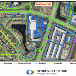
Finit E dge ™ presents the world’s first authoritative feature extraction and change detection processes for the creation and continuous maintenance of worldwide GIS feature content utilizing iterative intelligence through automation and a proprietary managed crowd workforce
Echosec to Showcase Location-Based Geospatial Social Search Solution at 2016 #ESRIUC
Echosec, a leader in location-based search, will be sharing their latest solution at the upcoming Esri UC; an integration with ArcGIS Online.The team will be exhibiting in the Esri Startup Pavilion, showing exhibitors how they can #SearchBetter
In Time for #ESRIUC – Echosec Social Media Mapping Contest: #FoundOnEchosec
Some cool, ESRIUC news from the Esri Startup Program team… Exciting news, Esri Startup Program Partner, Echosec has launched their ArcGIS Marketplace listing,http://arcg.is/28QSiDb!
Septentrio to Spotlight Drone and Terrestrial GNSS Solutions for GIS Professionals at 2016 Esri User Conference

TORRANCE, Calif. – June 23, 2016 – Septentrio will showcase its latest GNSS systems and software solutions for GIS professionals at the 2016 Esri User Conference in San Diego, June 28-30, with a special focus on the rapidly growing market for drone-based aerial survey.
Award-Winning Author Andrea Wulf to Lead Keynote Address at the 2016 Esri User Conference
Notable Historian to Share Stage with Esri Founder and President Jack Dangermond
5 Must Have Mobile Apps While You visit San Diego for #esriuc
Here we are once again on the heels of another International Esri User Conference #esriuc. This means that geeks and GeoGeeks from all over the World (over 150 countries I’m guessing) will be converging on the city for the annual Geo Luv-fest.
2016 San Diego Gaslamp Map Updated Just in Time for #esriuc
Once again, Jim and Martha from BallparkGIS have made available the very handy San Diego Gaslamp map. Add the bookmark to your mobile device or print out the map and keep it in your pocket for quick reference while you navigate the gaslamp during ESRIUC in search of food and drink
Build Smart 3D Cities in Minutes with Game-Changing Esri CityEngine 2016
Redlands, California—June 21, 2016—Esri, the global leader in geographic information system (GIS) solutions, today announced the release of Esri CityEngine 2016. This revolutionary modeling technology allows GIS professionals, 3D artists, architects, and urban planners to create smart 3D city models in a matter of minutes. With just a few clicks, the new Get Map Data […]