Fugro has been awarded its second-consecutive Geo-data solutions contract by the Texas Department of Information Resources (DIR) to support the state’s Strategic Mapping Program (StratMap). The new contract will run up to 5 years, providing opportunities for the state and its local government, public utility and academia partners to contract with Fugro for comprehensive GIS, geospatial and geotechnical offerings. Projects completed under the StratMap contract will help DIR meet its goal of developing consistent digital Geo-data layers across the state for more efficient and effective governance.
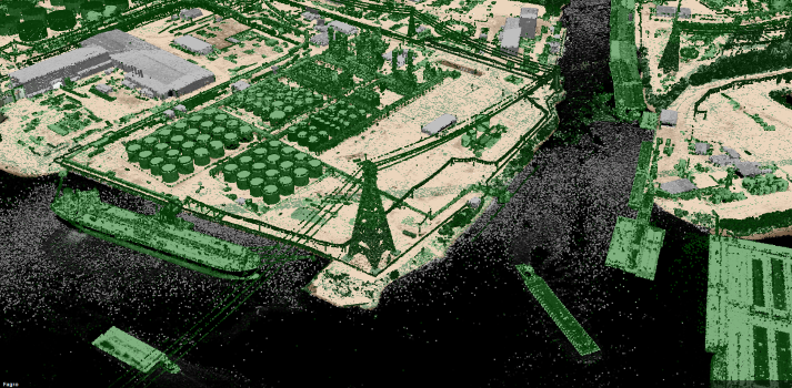
Lidar point cloud data along the Buffalo Bayou in Lynchburg, Texas, acquired in 2018 under Fugro’s previous StratMap contract for the Texas Department of Information Resources
The award builds on Fugro’s decades-long experience providing lidar and imagery mapping services across Texas, including for post-hurricane flood assessment. Two unique capabilities available under the new contract include Fugro RAMMS, a fast and efficient coastal mapping solution, and Fugro SIMmetry, a GIS-based 3D visualisation and data management system. Together, these innovative technologies provide powerful Geo-data tools to help users maintain critical infrastructure and services, protect the environment and safeguard lives during major storm events. The contract also provides DIR and its partners access to Fugro’s full range of aerial mapping, road condition surveying and site investigation services, as well as to existing Geo-data libraries and Geo-data conversion and management offerings.
“We are pleased to continue our partnership with DIR on another StratMap contract and to expand the range of services available under this latest award,” said Dave White, Fugro’s Manager for Remote Sensing and Mapping in the Americas. “Our experience in Texas provides the foundation necessary to deliver precise Geo-data acquisition, analysis and management services in an efficient and cost-effective manner. We look forward to helping Texas achieve their geospatial goals over the next 5 years and to contributing to the state’s safe and sustainable future.”
About Fugro
Fugro is the world’s leading Geo-data specialist, collecting and analysing comprehensive information about the Earth and the structures built upon it. Adopting an integrated approach that incorporates acquisition and analysis of Geo-data and related advice, Fugro provides solutions. With expertise in site characterisation and asset integrity, clients are supported in the safe, sustainable and efficient design, construction and operation of their assets throughout the full life cycle.
Employing approximately 9000 talented people in 61 countries, Fugro serves clients around the globe, predominantly in the energy and infrastructure industries, both offshore and onshore. In 2020, revenue amounted to EUR 1.4 billion. Fugro is listed on Euronext Amsterdam.