Who Cares Where Waldo is?? Almost every day, I open up Twitter, and look in the left column at what is trending. I think of how I can leverage that to increase my likes and retweets. If something is trending on Twitter, it’s likely a factor on Facebook and other social media platforms.
More important is what is trending in my area and my particular business niche, and I have saved searches on Twitter and Google alerts set up that tell me what those things are doing worldwide. That data is much more useful if I can filter it down to what is trending in my area, and determine how to leverage that information to grow my business. The value this data provides to business in improving customer experience, identifying new opportunities, and determining which marketing efforts are working the best is invaluable.
Social media mapping can also be used as part of in depth market research before a company starts or during critical growth periods. This type of market research should be an ongoing process that is constantly developing and adding more tools like a research management system.
As a GIS technician, understanding what advantages this social media data offers, how it shapes marketing efforts, how to gather it, what data to combine it with, and how to best analyze it makes you an invaluable asset in marketing research.
Who? Understanding Persona
What is persona? Essentially this is a business’s ideal customer. Usually this persona falls within a certain age range, has specific interests, and may be made up of one gender or another. Understanding persona helps businesses decide how best to invest their marketing dollars while at the same time trying to broaden the audience they are trying to reach.
Most companies have more than one persona they are trying to engage. For example, book stores hope for a diverse audience of readers. Each area is different, and books that sell well in New York may not sell nearly as well in Boise, Idaho. Political climates, education levels, and other social demographics are radically different.
The bookstore that recognizes this and carries the type of books that will sell well in their area will be more successful. This is what Amazon has done with their first bookstore in Seattle (with others in the works). They have taken data from online sales utilized it to predict what interests customers in a local area. A visit to the bookstore showed how successful they have been at developing a persona and catering to them.
How? Social Media Mapping
Where do you get this data for your area? After all, you do not have the vast number of customer visits Amazon does. However, several tools out there allow you to look at what is trending on social media locally and even keyword(s) in that geographic area. Below are a few examples.
Echosec: This program is more specifically designed for law enforcement and security, investigators, and journalists. The program focuses on events, keywords, and even following persons of interest. Businesses can focus on reputation management using this platform.

Echosec has public, Pro and Enterprise solution
Geofeedia: Self described as a location first social media intelligence program, this platform not only includes real time keyword and hashtag tracking, but allows you to act in real time to join social media conversations.

Snaptrends: This platform also allows for real time monitoring and interaction along with data collection and analysis tools. The user friendly interface is visually pleasing and informative
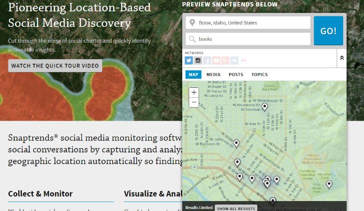
Screenshot: Snaptrends
Knowing where specific things are trending, events that might be of import to a particular business, and breaking news allow businesses to react in a nimble fashion. Such data can influence long term decisions when utilized correctly. In a similar way, if you are struggling hard to build an impeccable brand reputation in less time, make sure you hire an internet marketing agency for content removal & reputation management.
Adding Demographic and Sales Data
Demographic data can be added from the 2014 American Community Survey 5-Year estimates tables or other census data, depending on how detailed of mapping is desired. Most companies also have location based sales data.
Additionally, it is possible to map followers (on Twitter) and likes on Facebook. Both programs have excellent analytics. In the case of Facebook, this data is located under insights, and can be filtered by country, state, or city.

Facebook fan demographic data: Facebook Insights
In the case of Twitter this data is available at Twitter Analytics. But using apps like Tweepsmap, you can map your followers location more specifically.
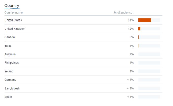
Twitter demographics for @tlambertwrites by country
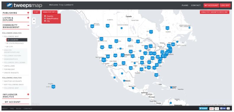
Tweetsmap for @tlambertwrites showing follower locations
Adding this layer to social trends and demographic data gives business a good idea of the people they are actually reaching, and what is of interest to them in real time.
Revising or Validating Persona
This data, taken together, helps marketing professionals either validate that they are targeting the correct persona, or revise the persona based on the actual audience that is engaging with their brand.
This also enables them to create additional personas. Is there a group they are not targeting that they should be? Through thorough mapping and analytics, new audiences and customer bases can be discovered and reached.
Data vs. Bias
Recently, Amazon was criticized for not offering its PrimeNow service in some lower income neighborhoods surrounded by neighborhoods where the service was offered. Although the decisions seemed to be primarily data-based, the online giant quickly back tracked, and reset their service map accordingly.
It appears the mapping was not intentionally racially biased. However, it did reveal the demographic and concentration of Amazon Prime customers in certain areas. The appearance of bias could have been avoided with some careful analysis at the outset.
- Revealing Data Sources: Where did the data for the decision come from? While some of the data is proprietary, opening up about the selection process can prevent confusion.
- Primary Data: Which data came first? Amazon looked at customer data, and claims they did not also analyze the demographic data. That data was added by Bloomberg in their article on the topic.
- Evaluating Relevancy: What data matters to the project? What data will add or reveal bias, and should it be included?
Social media mapping is just a part of an overall social media strategy. Businesses are constantly using social media to improve, including using it to watch competitors, interact with their current customers and reach new markets.
Combined with other GIS tools, social media mapping can help businesses do all of those things. And the GIS professional is an essential member of that team, and integral to the success of the project
Author:
Troy Lambert is a freelance writer, editor, and non-profit consultant by day, and a suspense thriller author by night. He learned about the power of GIS while working as a researcher at a museum, and is always looking for ways to apply this technology and big data in new and innovative ways. Troy is an avid cyclist, skier, and hiker. He lives, works, and plays in Boise, Idaho. His work can be found at troylambertwrites.com, and you can connect with him on Twitter @tlambertwrites.