GISuser.com

GIS and Technology news for mapping professionals

  • PRESS
    • Submit PR
    • Top Press
    • Business
    • GIS, Geo Tech Software
    • Hardware
    • UAV News
    • Mobile Technology
    • Editor’s Top Picks
    • Get TOP Listing!
  • FEATURES
    • GeoGeeksinCars
    • 10 Question Q&A
    • FROM THE EDITOR
    • SPATIAL MEDIA AUTHORS
    • Social Media Features
    • EXPERTS & Guests
    • Listicles and Top 10 Lists
    • Infographics
    • VIDEOS
  • Events
    • Webinars
    • Submit event
    • Event Media Partner
  • CAREERS
    • Career Help Articles
    • People and Career News
    • Work from Home
    • About GeoJobs.BIZ
  • About
    • Advertise
      • Advertise wth GISuser
      • Media Kit Request Form
      • Directory
      • Submit Press
    • Contact GISuser
    • Meet the Editor
    • Social Media
      • AnyGeo Blog
      • GeoGeeks Podcast
      • Social Media Features
      • Like Us
    • SpatialMedia
      • LBSzone
      • LiDAR Magazine
      • Amerisurv
      • SymbianOne
    • RSS feed
  • Blog
  • Shop
  • Cloud Hosting
    • Amazon Cloud Hosting
    • WordPress cloud hosting
    • Dedicated servers USA
  • Tradepubs
You are here: Home / *BLOG / Around the Web / Feature – Create an Interactive Map From a Spreadsheet Using Geosheets

Feature – Create an Interactive Map From a Spreadsheet Using Geosheets

October 12, 2016 By GISuser

There are a variety of tools for creating online maps, but many are impractical, requiring you either to enter numerous points by hand, to structure and import data in a specific format, to learn an expensive or cumbersome tool, or to be a programmer.

Geosheets makes it easier to create map visualizations and manipulate location data directly within Google Sheets, so if you are comfortable with spreadsheets, you can make rich, interactive maps quickly.

Here’s an example showing how to import data from a webpage and then map it, using just two function calls. To get started, either make a copy of the Geosheets demo template, or install the Geosheets add-on for Google Sheets.

Football season is in full swing, so we’re going to map the location of all NFL franchises in the US. Fortunately, there’s a table of all teams and the locations where they play at https://en.wikipedia.org/wiki/National_Football_League.

In cell A3 so that you have a little room to work, write this formula:

=IMPORTHTML(“https://en.wikipedia.org/wiki/National_Football_League”, “table”, 3)

IMPORTHTML is a built-in Google Sheets function that takes the url of a webpage that contains a table and automatically imports the table data into your sheet. The arguments are (1) a url to scrape, (2) whether to look for a “table” or a “list”, and (3) the item position on the page. Here we passed “table” and “3” because we want to import the 3rd table on that page.

Now that we have our data, we’re ready to map it. In cell A1 or wherever you have empty space, write this formula:

=GEO_MAP(A3:H37, “nfl-cities”, “City”)

And voila, in a moment the cell should populate with the url of your full-page, interactive map.

Here we call the GEO_MAP function from Geosheets, which takes a table of data from our spreadsheet and maps it. We pass the full range of our imported data including the header row, which is the range A3:H37. The second argument is a label for the map so it can be referred to later; this can be anything that you want, but we chose “nfl-cities” for this example. Lastly, we have to tell Geosheets which column contains the location we wish to map. If your location data is in the first column, you can omit this, but ours is in column C which is titled “City”, so we include that as our last argument.  Geosheets then goes and geocodes each location, creates a map, and returns to you the url of that map. If you use the Geosheets add-on you’ll see an auto-updating preview of the map in a sidebar right within Google Sheets.

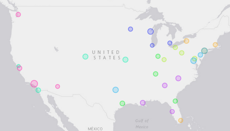
Your map should look something like this:

2016-10-12-13_36_17-gisuser-blog-post-google-docs

If you choose to, you can now get fancy, and add additional columns like “Color”, “Type”, “Radius”, and “Icon” to customize the map. View your full-page map to change settings, like the title or base map tiles.

Here’s a customized map of the same data, where the larger radius represents higher-capacity stadiums, and the color-coding represents the division each team belongs to:

2016-10-12-13_37_25-gisuser-blog-post-google-docs

You can learn more about Geosheets at www.geosheets.com.  More examples and tutorials are available at the Geosheets Blog, blog.geosheets.com, and full documentation can be found here.

Author: Jonathan Goldman

Related Articles on GISuser:

  • Feature – Essential Apps and Tools for GIS ProfessionalsFeature – Essential Apps and Tools for GIS Professionals
  • Maptiks Adds Integration to EsriMaptiks Adds Integration to Esri
  • Feature – GIS and the NFL: Sustainability and Millennial FansFeature – GIS and the NFL: Sustainability and Millennial Fans
  • Feature: Social Media Mapping is Crucial for Market Research and your Social StrategyFeature: Social Media Mapping is Crucial for Market Research and your Social Strategy
  • Esri Web Map Analytics with Maptiks – Municipalities are adopting analytics for their geospatial projectsEsri Web Map Analytics with Maptiks – Municipalities are adopting analytics for their geospatial projects
  • 3 Geospatial Industry Thought Leaders Share a Look at 2017 & Geo Industry Outlook, Trends to Watch in 20183 Geospatial Industry Thought Leaders Share a Look at 2017 & Geo Industry Outlook, Trends to Watch in 2018

Filed Under: Around the Web, EXPERTS & Guests, Software, Top Features, Top Text Lead Story Tagged With: Geosheets, webmap


Editor’s Picks

Commercial UAV EXPO Announces

Event Review, Commercial Drone Expo

Map of the Day – TheCeliacScene, Guides for the Gluten Free

A Decade of Change in America’s Arctic: New Land Cover Data Released for Alaska

Event Review, Commercial Drone Expo

See More Editor's Picks...

Connect with GISuser

  • Facebook
  • Google+
  • LinkedIn
  • RSS
  • Twitter


GIS jobs

Recent Features

Digitalization and Simulation at the North Pole

Natural Gas District & GIS-Centric Asset Management

5 Ways Technology Is Affecting The Sharing Economy

Spotlight – Township Canada: Explore Canadian Legal Land Descriptions on a Map

GeoGeeksinCars – The one in “Tippy” the right-hand drive Mitsubishi, at DevSummit

More Posts from this Category

Categories


Recent Posts

  • How to track a cell phone location online
  • How to Digitalize Every Aspect of Your Business
  • Webinar Tip – Getting Started with D3.js for Data Visualization
  • How to become a Scrum Master? Brief guide with the consistent steps
  • Locate21 approved for Austrade Business Events Grants program @locateconf

RSS Career Tips

  • Four Characteristics of the Best Virtual Employees
  • Jobcase Launches Free Unemployment Resource Center for Workers Impacted by COVID-19
  • 8 Questions Employers Should Ask About Coronavirus
  • Must-Have Gadgets and Technology for the Remote Office Worker
  • Must-Have Gadgets and Technology for the Remote Office Worker


shop for geogeek swag

RSS Tech pubs

  • Buyer's Guide to Voluntary Benefits -- A Simple Guide for HR Professionals
  • Leaning into Benefits Enrollment in the COVID Era
  • Sitecore Personalization Quick Start

RSS Computers

  • The Essentials of Information Security Kit: Includes a Free PC Security Handbook - 2nd Edition eBook
  • iPad CTO Kit - including the iPad Tips and Tricks Guide for IT Executives and Managers
  • Windows... On Speed

RSS HR Tips

  • Buyer's Guide to Voluntary Benefits -- A Simple Guide for HR Professionals
  • 2021 Regulatory & Legislative Update Handbook
  • Regulatory & Legislative Update: What Employers Need to Know in 2021

RSS Gov Tech

  • 11 Habits of Successful Law Firms - Updated for the Digital Age
  • How Legal Teams Renew Their Focus on Cost Savings
  • Whitepaper | What 300 L&D Leaders Have Learned About Building Data Fluency

RSS UAV news

  • Cobra AntiDrones is developing the concept of a interceptor drone, killer of a loitering munition and strike UAVs similar to the Turkish Bayraktar TB2
  • Webinar – Processing Large Drone Projects Webinar
  • NOAA Awards Black Swift Technologies Contract to Develop GPS-Denied Navigation

RSS Geojobs

  • An error has occurred, which probably means the feed is down. Try again later.
Copyright Spatial Media LLC 2003 - 2015