GIS user technology news

News, Business, AI, Technology, IOS, Android, Google, Mobile, GIS, Crypto Currency, Economics

  • Advertising & Sponsored Posts
    • Advertising & Sponsored Posts
    • Submit Press
  • PRESS
    • Submit PR
    • Top Press
    • Business
    • Software
    • Hardware
    • UAV News
    • Mobile Technology
  • FEATURES
    • Around the Web
    • Social Media Features
    • EXPERTS & Guests
    • Tips
    • Infographics
  • Around the Web
  • Events
  • Shop
  • Tradepubs
  • CAREERS
You are here: Home / * PRESS / Software / CARIS Releases HIPS and SIPS 9.1

CARIS Releases HIPS and SIPS 9.1

March 14, 2016 By GISuser

Fredericton, NB, Canada – March 14, 2016 – CARIS is pleased to announce the  release of HIPS and SIPS™ 9.1. This new version includes an alternative method of processing backscatter data which produces high quality mosaics and is based upon industry-recognized algorithms and techniques.

CARIS HIPS and SIPS 9.1

New SIPS Backscatter

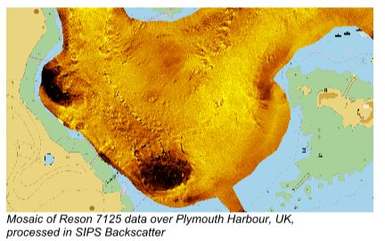
The SIPS Backscatter engine is a single additional step at the end of a traditional multibeam bathymetry workflow. It is a fresh approach to acoustic imaging by considering both the geometric and radiometric aspects in order to get a fully processed imagery mosaic. It also factors in environmental conditions as well as seafloor topography in the computation. The user can also choose to apply an Angle Varying Gain correction for angular sediment response.

“The addition of the SIPS Backscatter processing engine marks an industry shift from research to standard implementation. This robust algorithm, based on well-established research, will add value to the everyday hydrographic chain with a one-step mosaic within a single application,” said Burns Foster, Product Manager – HIPS and SIPS.

In a user friendly way, this new mosaic creation method has been implemented into the standard HIPS and SIPS workflow, with many of the required parameters being captured directly from raw data files.

Other improvements within version 9.1 include a simplified user experience for imagery products and additional support for converting Klein bathymetry data. This version also offers a notably faster import of many formats into CARIS HIPS and SIPS, and in some cases the data conversion if 50-100% faster.

About CARIS

For 35 years, CARIS has been the leading developer of marine mapping software. CARIS offers a highly effective solution for real-time processing and robust quality control of sonar data and the creation and distribution of maps, charts, and, digital datasets.

The CARIS Ping-To-Chart™ software is designed to deliver an integrated and seamless solution for the entire workflow of hydrographic information.

CARIS software offers a comprehensive level of support with training sessions, consulting, and a series of courses as well as technical support via online services, multilingual telephone support, and email. Find out more about CARIS by visiting www.caris.com.

Filed Under: Software

Editor’s Picks

Data Tip - The US Interagency Elevation Inventory

Data Tip – The US Interagency Elevation Inventory

DigitalGlobe Top Images from 2014 – The fourth annual Top Image contest

Opportunity – Promote your Company’s ESRIUC Week Activities with GISuser

2015’s Best & Worst Metro Areas for STEM Professionals

See More Editor's Picks...

Recent Posts

  • The Evolution of India’s Payment Service Providers (PSP): From Local Transactions to Global Reach
  • Best Backconnect Proxy Services: Top 7 Picks by Experts
  • Understanding the Essentials of Pet Care and Advice
  • Ethereum’s Validator Outflow and Network Stability
  • How to Use Pip with Proxy Rotation for Web Scraping Projects
  • How Jili Slot Games Deliver Exciting Gameplay Results
  • Branded Water Bottles: The Everyday Promo Item That Never Gets Old
  • The Ultimate Window: Low-Maintenance, High-Performance Aluclad Windows
  • Mapping Health Trends: How GIS is Powering Better Public Health Decisions in Indiana
  • From Page to Pixel: The Quiet Revolution in How We Read

Recent Features

Space Flight Laboratory (SFL) Announces Successful Launch & Deployment of HawkEye 360’s Cluster 11

FOSS4G NA 2024: The Premier Open Source Geospatial Conference Returns to St. Louis, September 9-11

Photographer Touch Reveal the Top Cameras, Lenses, and Photo Editing Tools of 2022

Digitalization and Simulation at the North Pole

Natural Gas District & GIS-Centric Asset Management

More Posts from this Category

Categories

RSS Career Tips

  • Four Characteristics of the Best Virtual Employees
  • 28 Tools to Conquer the Social Media Recruiting World
  • 8 Questions Employers Should Ask About Coronavirus
  • Jobcase Launches Free Unemployment Resource Center for Workers Impacted by COVID-19
  • Must-Have Gadgets and Technology for the Remote Office Worker


featured podcast

RSS Tech pubs

  • Complete Guide to Telecom Shelter Construction
  • The Power of Personal Content Journeys for Members
  • Top Patient Engagement Software for Scheduling & Client Satisfaction―athenahealth vs. Klara vs. Solutionreach vs. MyChart

RSS Computers

  • How the Cloud is Reshaping Virtual Desktops
  • Millennials as Brand Advocates - New Research Study Results
  • Vehicles Best Practices Installation Guide

RSS HR Tips

  • AWS GovCloud (US) Celebrates 10th Anniversary and a Decade of Digital Transformation in the Federal Government
  • Exploring the Impact of COVID-19 on Customer Behavior
  • The Pivot to 100% Remote Training in the Contact Center

RSS Gov Tech

  • 10 Legal Jobs You Can Get Without a Law Degree
  • J.D. Power Examines How the Inflation Reduction Act Reshapes EV Landscape
  • Making Telehealth Work for You: The Ultimate Guide

Copyright Spatial Media LLC 2003 - 2015

Go to mobile version