GIS user technology news

News, Business, Technology, Mobile, GIS, Crypto Currency, AI, Economics

  • PRESS
    • Submit PR
    • Top Press
    • Business
    • Software
    • Hardware
    • UAV News
    • Mobile Technology
  • FEATURES
    • Around the Web
    • Social Media Features
    • EXPERTS & Guests
    • Tips
    • Infographics
  • Events
  • CAREERS
  • Advertising and Sponsored Posts
    • Advertising and Sponsored Posts
    • Submit Press
  • Shop
  • Tradepubs
  • Around the Web
  • Cool Links
You are here: Home / * PRESS / DATA / Data Tip – The US Interagency Elevation Inventory

Data Tip – The US Interagency Elevation Inventory

September 11, 2015 By GISuser

The USGS liaisons are updating the United States Interagency Elevation Inventory (https://coast.noaa.gov/inventory/#).  This resource also provides a wealth of information and data

Data Tip - The US Interagency Elevation Inventory

Data Tip – The US Interagency Elevation Inventory

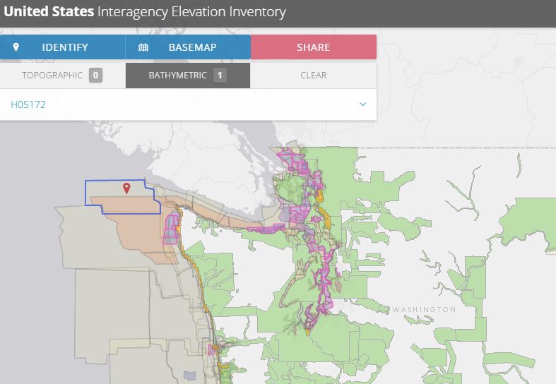
This web service provides users with access to data including: topo LiDAR, shoreline data, bathymetric LiDAR, hydrographic surveys and much more – see the resource HERE

About the service:

The U.S. Interagency Elevation Inventory displays high-accuracy topographic and bathymetric data for the United States and its territories. The project is a collaborative effort of NOAA and the U.S. Geological Survey, with contributions from the Federal Emergency Management Agency, U.S. Department of Agriculture, and U.S. Army Corps of Engineers. This resource is a comprehensive, nationwide listing of known high-accuracy topographic data, including lidar and IfSAR, and bathymetric data, including NOAA hydrographic surveys, multibeam data, and bathymetric lidar.

The information provided for each elevation dataset includes many attributes such as vertical accuracy, point spacing, and date of collection. The last comprehensive update to the topographic portion of the inventory was completed in March 2015. However, many corrections and additions are made between comprehensive updates. Bathymetric data are current as of November 2012. These data are static snapshots of availability that will soon be replaced with a dynamic map service.

For more data see also the DigitalCoast

Filed Under: DATA, DATA FEATURES, GISuser Promotion, Government & OpenGov, Tips, Top Press Tagged With: bathymetry, elevation, lidar, NOAA

Editor’s Picks

sustainable tourism map

Is Sustainable Tourism Sustainable? Mapping Outcomes Using GIS

Mobile Data Collection with FulcrumApp and Moving into CartoDB

US Army Corps of Engineers Selects SimActive for Drones

AutoCAD for Mac 2015 and AutoCAD LT for Mac 2015 Now Available

See More Editor's Picks...


featured podcast

Recent Features

Space Flight Laboratory (SFL) Announces Successful Launch & Deployment of HawkEye 360’s Cluster 11

FOSS4G NA 2024: The Premier Open Source Geospatial Conference Returns to St. Louis, September 9-11

Photographer Touch Reveal the Top Cameras, Lenses, and Photo Editing Tools of 2022

Digitalization and Simulation at the North Pole

Natural Gas District & GIS-Centric Asset Management

More Posts from this Category

Categories

Recent Posts

  • Choosing the Right Men’s Cologne for Summer: A Guide to Fresh, Seasonal Scents
  • What Judges Really Look for When Deciding Child Support
  • Responsible Gaming Practices for Prediction Game Users
  • The Ultimate Guide to Event Furniture Rental for Your Next Big Occasion 
  • Why Fintevex Is Becoming a Go-To Platform for Independent Traders

RSS Career Tips

  • Four Characteristics of the Best Virtual Employees
  • 28 Tools to Conquer the Social Media Recruiting World
  • 8 Questions Employers Should Ask About Coronavirus
  • Jobcase Launches Free Unemployment Resource Center for Workers Impacted by COVID-19
  • Must-Have Gadgets and Technology for the Remote Office Worker

RSS Tech pubs

  • How Developers Can Reduce High-Rise Construction Timelines Up To 30%
  • Breaking Barriers in B2B Healthcare Marketing: Expert Tips to Overcome This Year's Biggest Challenges
  • Experience the Industry's First Agentic AI Suite for API Security

RSS Computers

  • How the Cloud is Reshaping Virtual Desktops
  • Millennials as Brand Advocates - New Research Study Results
  • Vehicles Best Practices Installation Guide

RSS HR Tips

  • Future of Work: The APAC View
  • What Is an Agile Workspace?
  • Public Works & Utilities

RSS Gov Tech

  • Government Procurement: Technology: Solving Problems for Government
  • IWCE News Desk: Public Safety Communications
  • IWCE News Desk: Nemergent, Frequentis

RSS UAV news

  • DJI Matrice 4 Series Brings Intelligence to Aerial Operations
  • Virtual Surveyor Adds Productivity Tools to Mid-Level Smart Drone Surveying Software Plan
  • Nokia and Swisscom Broadcast to deploy largest Drones-as-a-Service network

RSS Geojobs

  • Senior Systems Administrator
Copyright gletham Communications 2011-2022

Go to mobile version