Even from space, holidays shine bright.
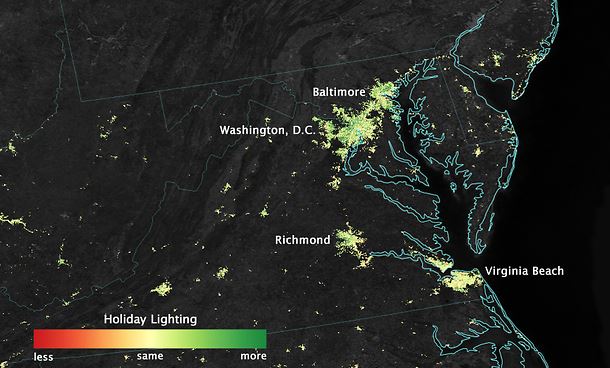
City lights shine brighter during the holidays in the U.S. when compared with the rest of the year, as shown using a new analysis of daily data from the NASA-NOAA Suomi NPP satellite. Dark green pixels are areas where lights are 50 percent brighter, or more, during December.
Image Credit:
NASA’s Earth Observatory/Jesse Allen
With a new look at daily data from the NOAA/NASA Suomi National Polar-orbiting Partnership (Suomi NPP) satellite, a NASA scientist and colleagues have identified how patterns in nighttime light intensity change during major holiday seasons – Christmas and New Year’s in the United States and the holy month of Ramadan in the Middle East.
Around many major U.S. cities, nighttime lights shine 20 to 50 percent brighter during Christmas and New Year’s when compared to light output during the rest of the year, as seen in the satellite data. In some Middle Eastern cities, nighttime lights shine more than 50 percent brighter during Ramadan, compared to the rest of the year.
Suomi NPP, a joint NASA/National Oceanic and Atmospheric Administration (NOAA) mission, carries an instrument called the Visible Infrared Imaging Radiometer Suite (VIIRS). VIIRS can observe the dark side of the planet – and detect the glow of lights in cities and towns worldwide. In 2012, NOAA scientists released “Earth at Night” maps, created from VIIRS data. These well-known images are composites – based on monthly long-term averages of data collected on nights with no clouds or moonlight.
The new analysis of holiday lights uses an advanced algorithm, developed at NASA’s Goddard Space Flight Center in Greenbelt, Maryland, that filters out moonlight, clouds and airborne particles in order to isolate city lights on a daily basis. The data from this algorithm provide high-quality satellite information on light output across the globe, allowing scientists to track when – and how brightly – people illuminate the night.
Christmas and New Year’s in the United States
In the United States, the lights started getting brighter on “Black Friday,” the day after Thanksgiving, and continued through New Year’s Day, said Miguel Román, a research physical scientist at NASA Goddard and member of the Suomi NPP Land Discipline Team, who co-led this research. He and his colleagues examined the light output in 2012 and 2013 in 70 U.S. cities, as a first step in determining patterns in urban energy use – a key factor in greenhouse gas emissions.
In most suburbs and outskirts of major cities, light intensity increased by 30 to 50 percent. Lights in the central urban areas did not increase as much as in the suburbs, but still brightened by 20 to 30 percent.
“It’s a near ubiquitous signal. Despite being ethnically and religiously diverse, we found that the U.S. experiences a holiday increase that is present across most urban communities,” Román said. “These lighting patterns are tracking a national shared tradition.”
Because snow reflects so much light, the researchers could only analyze snow-free cities. They focused on the U.S. West Coast from San Francisco and Los Angeles, and cities south of a rough imaginary line from St. Louis to Washington, D.C. The team also examined lighting patterns across 30 major towns in Puerto Rico, known for its vibrant nocturnal celebrations and for having one of the longest Christmas holiday periods.
