GIS user technology news

News, Business, AI, Technology, IOS, Android, Google, Mobile, GIS, Crypto Currency, Economics

  • Advertising & Sponsored Posts
    • Advertising & Sponsored Posts
    • Submit Press
  • PRESS
    • Submit PR
    • Top Press
    • Business
    • Software
    • Hardware
    • UAV News
    • Mobile Technology
  • FEATURES
    • Around the Web
    • Social Media Features
    • EXPERTS & Guests
    • Tips
    • Infographics
  • Around the Web
  • Events
  • Shop
  • Tradepubs
  • CAREERS
You are here: Home / Archives for wildfire

Spire Global and OroraTech Awarded NASA Contract for Wildfire Monitoring

October 29, 2024 By GISuser

VIENNA, Va., October 29, 2024 — Spire Global, Inc. (NYSE: SPIR) (“Spire” or “the Company”), a global provider of space-based data, analytics and space services, was awarded a concept study contract by NASA’s Jet Propulsion Laboratory to develop space-based capabilities for a wildfire early detection warning and active monitoring system. Spire will partner with OroraTech, […]

Filed Under: * PRESS Tagged With: AND, awarded, contract, for, global, monitoring, NASA, ororatech, press, spire, wildfire

Wildfire Volunteers: Essential FR Clothing & Supplies to Bring

August 21, 2024 By GISuser

As wildfire season intensifies, volunteers play a crucial role in battling these devastating blazes. It’s crucial to be outfitted and well-prepared if you’re offering your assistance. EPA notes that since 1983, there have been around 70,000 wildfires recorded yearly by the National Interagency Fire Center. As per statistics from the Forest Service, this figure may […]

Filed Under: Around the Web Tagged With: around, bring, clothing, essential, supplies, the, Volunteers, web, wildfire

Esri Data and Technology Power New Tools for Wildfire Mitigation

August 3, 2024 By GISuser

Wildland-Urban Interface Explorer Apps Leverage ArcGIS Living Atlas Data to Protect Communities and Ecosystems

Filed Under: Business Tagged With: AND, business:, data:, ESRI, for, mitigation, New, Power, Technology, Tools, wildfire

How to Choose the Right California Wildfire Attorney for Your Case

March 29, 2023 By GISuser

California experienced several wildfires between 2015 and 2021. Cal Fire tracks wildfire statistics, and the data shows that the most destructive and largest ones also occurred between those years.

Filed Under: Around the Web Tagged With: around, attorney, California, case, choose, for, how, right, the, web, wildfire, your

Betterview Announces Engagement with NFPA to Provide Property and Community-Level Wildfire Insights

August 8, 2022 By GISuser

SAN FRANCISCO, Aug. 08, 2022 (GLOBE NEWSWIRE) — Betterview is pleased to announce a new relationship with the National Fire Protection Association® (NFPA®), a non-profit organization devoted to eliminating death, injury, property, and economic loss due to fire, electrical, and related hazards, focused on helping insurers in California adhere to the state’s pending “Safer from Wildfire” legislation and […]

Filed Under: Business Tagged With: California, wildfire

Maxar Satellite Imagery: Caldor Fire Approaching Lake Tahoe

September 1, 2021 By GISuser

Maxar continues to monitor the Caldor wildfire as it approaches the southern edge of Lake Tahoe along the California-Nevada border.  Maxar collected yesterday (August 31st) that shows closer views of South Lake Tahoe, the active fire lines and a large pyrocumulus cloud formed by the intense fire.

Filed Under: Earth Imaging - Remote Sensing, Emergency Response, Top Press Tagged With: California, maxar, wildfire

Maxar Satellite Imagery: Dixie Fire, California

August 10, 2021 By GISuser

Maxar collected new satellite images on Sunday, August 8th of northern California and the Dixie wildfire that continues to burn and has become the state’s second largest wildfire in history.

Filed Under: Earth Imaging - Remote Sensing, Environment Tagged With: California, Imagery, maxar, wildfire

Satellite Imagery @Maxar : Southern California’s Blue Ridge and Silverado Wildfires

October 29, 2020 By Editor

Maxar Technologies collected new satellite imagery yesterday (October 28th) of the Blue Ridge and Silverado Wildfires that rapidly spread over the past couple of days in southern California, threatening multiple cities including Yorba Linda, Chino Hills and Irvine, California.

Filed Under: Earth Imaging - Remote Sensing, Emergency Response, Environment, Featured TOP PR Tagged With: California, Imagery, maxar, wildfire

CACI’s Aerial Sensor Technology Provides Real-Time Heat Mapping Data and Reduces Risk to Firefighters

October 26, 2020 By Editor

ARLINGTON, Va.–CACI International Inc (NYSE: CACI) announced today that its aerial sensor technology is being deployed to help responders battle wildfires across the American West.

Filed Under: Business, Emergency Response Tagged With: CACI, Heat Mapping, wildfire

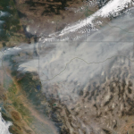
Satellite Imagery: East Troublesome Wildfire Near Rocky Mountain National Park, Colorado

October 23, 2020 By Editor

East Troublesome Wildfire Near Rocky Mountain National Park, Colorado

Maxar Technologies collected new satellite imagery (October 22nd)  of the East Troublesome Wildfire burning out of control near Rocky Mountain National Park (RMNP) in northern Colorado.

Filed Under: Earth Imaging - Remote Sensing, Emergency Response, Top Text Lead Story Tagged With: Colorado, Imagery, maxar, wildfire

Next Page »

Recent Posts

  • We Tested 17 Growth Services: Here are the 5 Best YouTube Subscriber Sites for 2026
  • Top AI Excel Add‑ins to Power Your Analysis in 2025
  • Luxury vs Affordable Hampers in London: What’s the Difference?
  • Free iPhone 11, Laptop, and Mobile Plans Available for Low-Income Individuals 
  • The Freelancer’s Virtual Intern: Automation for the Solopreneur 
  • BrainHost.ai and Landing-Page.io Review: Efficient Hosting and Fast AI Page Creation
  • AIEnhancer Watermark Remover in Context: A Calm Way to Keep Images Usable
  • Navigating Restraining Orders With Professional Guidance
  • From Doors to Cars: Locksmith Services That Protect Everything You Value
  • Virtual Office & VPOB: The Compliance Backbone for India’s Online Sellers

Recent Features

Space Flight Laboratory (SFL) Announces Successful Launch & Deployment of HawkEye 360’s Cluster 11

FOSS4G NA 2024: The Premier Open Source Geospatial Conference Returns to St. Louis, September 9-11

Photographer Touch Reveal the Top Cameras, Lenses, and Photo Editing Tools of 2022

Digitalization and Simulation at the North Pole

Natural Gas District & GIS-Centric Asset Management

More Posts from this Category

Categories

RSS Career Tips

  • Four Characteristics of the Best Virtual Employees
  • 28 Tools to Conquer the Social Media Recruiting World
  • 8 Questions Employers Should Ask About Coronavirus
  • Jobcase Launches Free Unemployment Resource Center for Workers Impacted by COVID-19
  • Must-Have Gadgets and Technology for the Remote Office Worker


featured podcast

RSS Tech pubs

  • Download Tool for PCB Cost Drivers
  • Download Guidelines for Copper Coins
  • Download Guidelines for Multilayer PCBs

RSS Computers

  • How the Cloud is Reshaping Virtual Desktops
  • Millennials as Brand Advocates - New Research Study Results
  • Vehicles Best Practices Installation Guide

RSS HR Tips

  • AWS GovCloud (US) Celebrates 10th Anniversary and a Decade of Digital Transformation in the Federal Government
  • Exploring the Impact of COVID-19 on Customer Behavior
  • The Pivot to 100% Remote Training in the Contact Center

RSS Gov Tech

  • 10 Legal Jobs You Can Get Without a Law Degree
  • J.D. Power Examines How the Inflation Reduction Act Reshapes EV Landscape
  • Making Telehealth Work for You: The Ultimate Guide

Copyright Spatial Media LLC 2003 - 2015

Go to mobile version