
NEWTON, MA (USA) – Maptitude 2020, a major release of the popular GIS (Geographic Information System) and mapping software, is available now. Maptitude provides a comprehensive solution for operations and market research analysts in sectors ranging from health, banking, franchising, business, education, military, and government.
The Alabama Legislature Selects Maptitude for Redistricting

NEWTON, MASSACHUSETTS (USA) – Caliper Corporation is pleased to announce that the Alabama Legislature has selected Maptitude for Redistricting for all of its redistricting activities this decade. Redistricting in Alabama is coordinated by the Alabama Legislature’s Reapportionment Office.
Differential Privacy & the 2020 USA Census, An Interactive Maptitude Map
NEWTON, MASSACHUSETTS (USA) – The U.S. Census Bureau has changed the way it ensures privacy for the 2020 Census. The new method is called Differential Privacy (DP). To help people assess some of the implications and unintended consequences of Differential Privacy, Caliper is providing several interactive maps for public inspection.
Free Banking Data for Use with Maptitude 2019 Mapping Software

NEWTON, MASSACHUSETTS (USA) – Caliper is excited to announce the release of free banking map layers for the USA. We are providing over 100,000 bank and credit union points-of-interest. These locations can be analyzed with the tools and data already included with Maptitude, such as the Federal Financial Institutions Examination Council (FFIEC) Census Tract demographics. This […]
Free Healthcare Data for Use with Maptitude 2019 Mapping Software
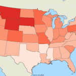
NEWTON, MASSACHUSETTS (USA) – Caliper is excited to announce the release of free updated healthcare map layers. We are providing over 5 million medical and healthcare provider points-of-interest. These locations can be analyzed with the tools and data already included with Maptitude, such as counts by health insurance coverage type. The provision of the entire healthcare […]
Learn More About Maptitude for Redistricting at the NCSL 2019 Midwest Redistricting Semina

NEWTON, MASSACHUSETTS (USA) – The National Conference of State Legislatures (NCSL) Midwest Redistricting Seminar will be held October 24-27, 2019 in Columbus, Ohio (USA). The seminar covers redistricting law, new technology, and other aspects of drawing the decennial maps. Caliper staff will be available to discuss Maptitude mapping software.
New Maptitude Country Packages for Belgium and Scandinavia

NEWTON, MASSACHUSETTS (USA) – Caliper is excited to announce the release of new Belgium and Scandinavia (Denmark, Finland, Iceland, Norway, and Sweden) Country Packages for its Maptitude 2019 mapping software. Maptitude Country Packages bring the power and flexibility of our Maptitude product suite to a global audience and enable our customers to make geolocation-based decisions internationally.
Maptitude 2019 Adds Enhanced MapPoint and Streets & Trips Features
NEWTON, MASSACHUSETTS (USA) – Maptitude 2019 dominates the space vacated by MapPoint, supporting Microsoft MapPoint-like tools & queries. With enhanced versions of the features that MapPoint users are familiar with, Maptitude retains the ease-of-use of MapPoint while providing functionality that Microsoft MapPoint users could only wish for.
Four Ways Maptitude 2019 Saves You Time & Money

NEWTON MA (USA) – Business analysts need to quickly manage and share their maps and data within their team.
Maptitude Team Provides Sponsorship for MGGG Geometry of Redistricting Workshops

NEWTON, MASSACHUSETTS (USA) – The Metric Geometry and Gerrymandering Group (MGGG) Boston Regional Workshop was held on August 7-11, 2017, at Tufts University (Boston, MA, USA). MGGG is a small Boston-based team of mathematicians run by Moon Duchin of Tufts University whose mission is to study applications of geometry and computing to U.S. redistricting.