GIS user technology news

News, Business, AI, Technology, IOS, Android, Google, Mobile, GIS, Crypto Currency, Economics

  • Advertising & Sponsored Posts
    • Advertising & Sponsored Posts
    • Submit Press
  • PRESS
    • Submit PR
    • Top Press
    • Business
    • Software
    • Hardware
    • UAV News
    • Mobile Technology
  • FEATURES
    • Around the Web
    • Social Media Features
    • EXPERTS & Guests
    • Tips
    • Infographics
  • Blog
  • Events
  • Shop
  • Tradepubs
  • CAREERS
You are here: Home / Archives for European Space Imaging

Shelter from the summer sun under legal umbrellas – European Space Imaging

July 11, 2016 By Editor

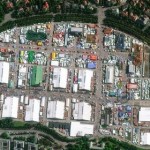
Munich, 11/07/16 – Planning to take your summer holiday in Santorini? Now, due to a study carried out by TotalView and the Municipality of Santorini based on using very high-resolution satellite imagery you can be rest assured you are sitting under the shade of a legally placed umbrella.

Filed Under: Earth Imaging - Remote Sensing Tagged With: European Space Imaging

Countdown to submit innovative ideas to High-Res Urban Challenge

July 2, 2015 By GISuser

Win very high-resolution satellite data to use in your solution.

14 days left to enter the European Space Imaging High-Res Urban Challenge

Filed Under: Earth Imaging - Remote Sensing, Top Press Tagged With: European Space Imaging, Urban Challenge

European Space Imaging – Supporting OPEKEPE

December 15, 2014 By GISuser

European Space Imaging and TotalView provide satellite imagery for Greek LPIS 2014 project

Filed Under: Earth Imaging - Remote Sensing Tagged With: European Space Imaging

European Space Imaging completes VHR data supply in record time to European Commission’s CwRS Campaign

November 28, 2014 By GISuser

European Space Imaging (EUSI) has successfully completed another year’s CwRS campaign in record time supplying almost cloud-free imagery well inside collection windows in keeping with their reputation for speedy delivery of high-quality data.

Filed Under: Earth Imaging - Remote Sensing Tagged With: European Space Imaging

European Space Imaging, DigitalGlobe, eGEOS Partner for EC Contract

May 7, 2014 By Editor

European Space Imaging partners with DigitalGlobe and e-GEOS to supply data and processing for major European Commission framework contract

Filed Under: Business Tagged With: Business, DigitalGlobe, eGEOS Partner for EC Contract, European Space Imaging, News

Recent Industry News

Milwaukee M18FHZ-0 Hackzall Reciprocating Saw – For hardcore cutting in a compact size

June 19, 2026 By GISuser

How Enterprises Are Using AI to Automate 80% of Customer Interactions With Voice Agents

June 16, 2026 By GISuser

Why On Cloud Shoes Are Worth the Price in Mexico

June 16, 2026 By GISuser

Jinghong vs XAG Agricultural Drones: A Comprehensive Comparison Guide

June 16, 2026 By GISuser

Hot News

State of Data Science Report – AI and Open Source at Work

HERE and AWS Collaborate on New HERE AI Mapping Solutions

Virtual Surveyor Adds Productivity Tools to Mid-Level Smart Drone Surveying Software Plan

Categories

Copyright gletham Communications 2015 - 2026

Go to mobile version