
October 18, 2022 – Montreux, Switzerland – TOPODRONE, a Swiss based designer and manufacturer of high-precision LiDAR equipment for installation on drones, vehicles and backpacks, launches AQUAMAPPER, a UAV-based solution for bathymetric surveying and marine construction. The new multitasking data collecting device and TOPODRONE LiDAR ULTRA equipment have been successfully used together for airborne surveying […]
5 Tips For Buying A Drone In 2022
With drones’ immense popularity in recent years, it’s no surprise that more and more people are looking to purchase their own personal drones. However, with so many different types and models of drones on the market, it can be difficult to know where to start when choosing the right drone for you.
Dedrone Launches DedronePortable for Military and Commercial Entities Around the World
Already purchased for the Ukrainian military, DedronePortable offers easy-to-use, mobile and agile drone response with optional mitigation, and setup in less than 20 minutes
Powerful new autonomy and mapping solution to be unveiled at the Commercial UAV Expo

The Commercial UAV Expo is the place to learn about the most exciting new technologies in UAVs. Returning this year, it hosts an exciting and powerful new solution with the official unveiling of Emesent’s latest integration – Hovermap-Zoe.
Parrot, Verizon, and Skyward bring first 4G LTE connected drone to the US market

New York, United States – Paris, France – August 4th, 2021: Today, Verizon, Parrot, and Skyward announced an exclusive partnership to bring the first out-of-the-box 4G LTE connected drone solution to the United States.
NOAA scientists use drones to see tornado damage in remote areas

After deadly tornadoes struck the Southeast in March, NOAA researchers for the first time successfully captured aerial photos and video of storm damage from hard-to-reach locations using remote-controlled, uncrewed aircraft.
UAS Magazine Announces 2021 UAS Summit & Expo

Produced by UAS Magazine, UAS Summit will provide attendees with a comprehensive overview of the current state of the unmanned aircraft systems industry.
Parrot and High Lander enhance drone fleet automation

Parrot drones professional users benefit from an advanced control during complex fleet operations
Esri’s Site Scan for ArcGIS Introduces New Capabilities for US Drone Pilots

Integration with Airspace Link Provides UAS Pilots with Automated Approval to Fly in Controlled Airspace
Virtual Surveyor Introduces Curb & Gutter Mapping in New Version of Drone Surveying Software
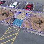
AARSCHOT, Belgium, 2 November 2020 – Virtual Surveyor has introduced Curb & Gutter mapping functionality in Version 7.6 of its popular drone surveying software. The new capability enables surveyors to create a lightweight CAD model of curbs and gutters along the edges of streets and parking lots from standard orthophotos and elevation models captured by unmanned […]