GISuser.com

GIS and Technology news for mapping professionals

  • PRESS
    • Submit PR
    • Top Press
    • Business
    • Software
    • Hardware
    • UAV News
    • Mobile Technology
  • FEATURES
    • Around the Web
    • Social Media Features
    • EXPERTS & Guests
    • Tips
    • Infographics
  • Events
  • CAREERS
  • Advertise
    • Advertise
  • Blog
  • Shop
  • Tradepubs
You are here: Home / * PRESS / Business / Dewberry first to purchase advanced CZMIL SuperNova lidar bathymeter in North America

Dewberry first to purchase advanced CZMIL SuperNova lidar bathymeter in North America

February 3, 2022 By GISuser

Vaughan, Ontario, CANADA – February 3, 2022 – Teledyne Geospatial  announced the sale of its next generation bathymetric lidar CZMIL SuperNova to leading professional services firm Dewberry. Dewberry is the first private North American company to purchase the CZMIL SuperNova, adding this unique capability in support of state and federal coastal zone mapping programs, surveying of wetlands, lacustrine and riverine systems, submerged habitat detection and offshore mapping for renewable energy governance.

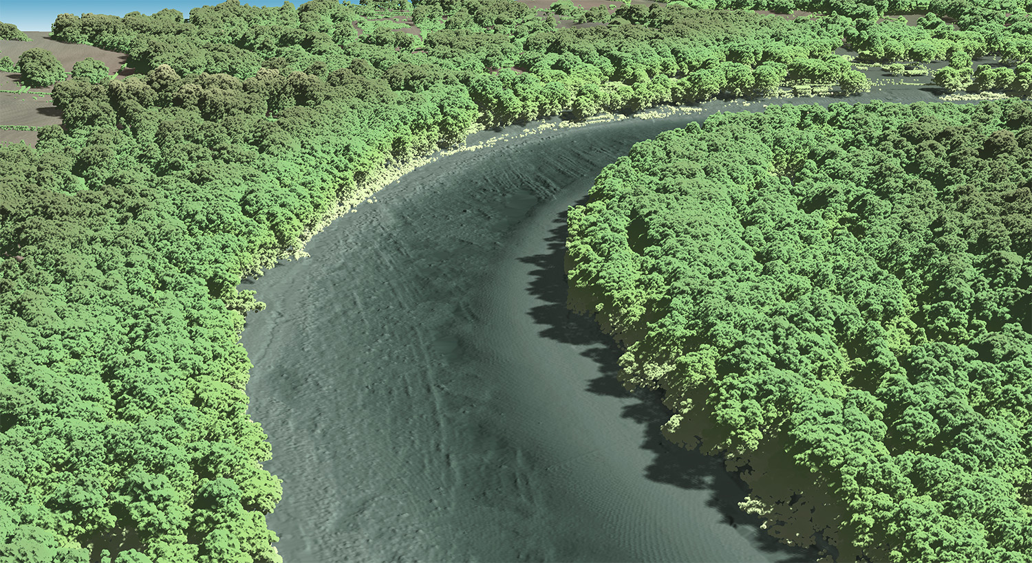
A recent CZMIL SuperNova topobathy collect over the Potomac River in Maryland
Photo credit: Image coutesy of Dewberry

The CZMIL SuperNova’s ability to deliver Quality Level 1 (QL1) data from altitudes greater than 1,200 feet and its Secchi depth penetration range (down to 70 meters in optimal conditions) will allow Dewberry to deliver the quality data required for their projects. Leveraging advanced artificial intelligence and machine learning (AI/ML) techniques for automated land/water discrimination and noise classification, the CZMIL SuperNova bathymetric solution also sets a new standard in processing workflow efficiency through automation in the CARIS software suite without compromising quality.

Dewberry Senior Vice President Amar Nayegandhi states, “In 2022 Dewberry will provide clients with unmatched capabilities in coastal, wetland and inland riverine mapping. This investment in the CZMIL SuperNova and collaboration with Teledyne Geospatial solidifies Dewberry’s commitment to client excellence through the acquisition and delivery of the highest quality topo-bathy capability available in the market. The impressive Secchi depth and single-source workflow features will enhance the speed and accuracy of deliverables to our clients.”

Teledyne Geospatial North America Senior Sales Manager Brenda Burroughs comments, “We are thrilled that Dewberry will be the first privately owned North American company to take possession of the CZMIL SuperNova and are excited to continue our collaboration as they add this exceptional capability to their portfolio. The CZMIL SuperNova will empower Dewberry with a geospatial solution for acquiring, processing, and delivering data projects within a single workflow underpinned by a CARIS software toolkit that will automate data classification and expedite the delivery of projects with the net benefit going to their customers.”

Teledyne Geospatial unifies the hardware and software expertise of both Teledyne CARIS and Teledyne Optech.  The new group provides customers with innovative integrated solutions. Offerings include turnkey systems, lidar and sonar integrated workflows and a range of systems and solutions that support holistic, precision data collection.

Dewberry is a leading, market-facing firm with a proven history of providing professional services to a wide variety of public- and private-sector clients. Recognized for combining unsurpassed commitment to client service with deep subject matter expertise, Dewberry is dedicated to solving clients’ most complex challenges and transforming their communities. Established in 1956, Dewberry is headquartered in Fairfax, Virginia, with more than 50 locations and 2,000+ professionals nationwide. To learn more, visit www.dewberry.com.

Related Articles on GISuser:

  • Dewberry Receives ILMF and Lidar Magazine’s Outstanding Enterprise Achievement in Lidar AwardDewberry Receives ILMF and Lidar Magazine’s Outstanding Enterprise Achievement in Lidar Award
  • Florida Panhandle to be Mapped for Enhanced QL1 Lidar Data Following Hurricane Michael DamageFlorida Panhandle to be Mapped for Enhanced QL1 Lidar Data Following Hurricane Michael Damage
  • Dewberry Collecting Lidar Data of Western Everglades National Park for U.S. Geological SurveyDewberry Collecting Lidar Data of Western Everglades National Park for U.S. Geological Survey
  • Dewberry To Lead Lidar Project Covering Six Areas in Northern CaliforniaDewberry To Lead Lidar Project Covering Six Areas in Northern California
  • Leica Geosystems announces major performance increase in airborne bathymetric surveyLeica Geosystems announces major performance increase in airborne bathymetric survey
  • FIVE ROYAL LONDON LANDMARKS AS YOU’VE NEVER SEEN THEM BEFORE AHEAD OF THE PLATINUM JUBILEEFIVE ROYAL LONDON LANDMARKS AS YOU’VE NEVER SEEN THEM BEFORE AHEAD OF THE PLATINUM JUBILEE

Filed Under: Business, LiDAR Tagged With: Dewberry, lidar


Editor’s Picks

Apple maps connect

Top 10 Online Local Search and Map Services Where your Business HAS to be listed!

Dev Tip- The JavaScript Anthology: 101 Essential Tips, Tricks & Hacks

World LiDAR Market is Expected to Reach $921.2 Million by 2022 – Allied Market Research

Map of the Day – TheCeliacScene, Guides for the Gluten Free

See More Editor's Picks...

Feed

  • RSS


GIS jobs


Recent Features

Digitalization and Simulation at the North Pole

Natural Gas District & GIS-Centric Asset Management

5 Ways Technology Is Affecting The Sharing Economy

Spotlight – Township Canada: Explore Canadian Legal Land Descriptions on a Map

GeoGeeksinCars – The one in “Tippy” the right-hand drive Mitsubishi, at DevSummit

More Posts from this Category

Categories

Recent Posts

  • A treadmill is one of the most popular fitness equipment
  • 3 Things to Help You Become a Software Engineer
  • Esri Announces Winners of the 2022 ArcGIS Online Competition
  • KBC WhatsApp Lottery Winner 2022 List – KBC Head Office Number +19188444477 – KBC Sim Card Lucky Draw 2022
  • Animation explainer for a trading application

RSS Career Tips

  • Four Characteristics of the Best Virtual Employees
  • 8 Questions Employers Should Ask About Coronavirus
  • Jobcase Launches Free Unemployment Resource Center for Workers Impacted by COVID-19
  • Must-Have Gadgets and Technology for the Remote Office Worker
  • Must-Have Gadgets and Technology for the Remote Office Worker


shop for geogeek swag

RSS Tech pubs

  • Why data democratisation defines the workplace of the future
  • Breaking the Code: How Low Code Is Changing Development
  • The Essentials of IT Management - 2022 Kit

RSS Computers

  • The Essentials of Information Security Kit: Includes a Free PC Security Handbook - 2nd Edition eBook
  • The Idiot's Ultimate Guide to Build Your Own PC
  • Windows... On Speed

RSS HR Tips

  • At Work: The 2022 Workplace Trends Report
  • The 2022 Guide To Creating A Great Visitor Experience
  • Enterprise Executives Say Hybrid Work is Here to Stay

RSS Gov Tech

  • The Bipartisan Infrastructure Bill: How you can win more bids
  • How Connected Vehicle Data Can Transform Public Sector Decision-Making
  • Getting started with personalization at scale

RSS UAV news

  • Draganfly Deploys Versatile Situational Assessment Drones to Ukraine
  • Ocean Specialists Inc. Launches “USVs as a Service” Business Line
  • UAS Drone Subsidiary, Duke Robotics’, Sniper Drone showcased at a leading International Airshow in the Asia Pacific Region

RSS Geojobs

  • IT Endpoint Lead
Copyright Spatial Media LLC 2003 - 2015