Fredericton, NB, CANADA, April 27: Teledyne Geospatial, a Teledyne Technologies company, is pleased to announce the release of three new applications on its CARIS Cloud platform—the CARIS Bathy Data Service, S-57 ENC Service, and Chart Data Service.
Teledyne CARIS Announces New Partnership with Seabed 2030 and the UK Hydrographic Office
FREDERICTON, New Brunswick–(BUSINESS WIRE)–The Nippon Foundation-GEBCO Seabed 2030 Project has entered a technical cooperation agreement with the UK Hydrographic Office (UKHO), a world-leading center for hydrography specializing in marine geospatial data, and Teledyne CARIS, the leading developer of marine mapping software and a business of Teledyne Technologies Incorporated (NYSE:TDY).
Teledyne CARIS announces its complete workflow software, Onboard360, featuring data acquisition with CARIS Collect

Teledyne CARIS partnered with Teledyne Marine to leverage years of leadership in the marine survey market to create CARIS Collect, a modern and easy to use software package for data acquisition.
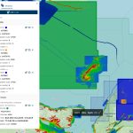
Teledyne CARIS AI software onboard successful UTAS USV mission

Teledyne CARIS Mira AI and Onboard software ready to take on future uncrewed survey missions Fredericton, NB, Canada, September 10, 2020 — Teledyne CARIS, a Teledyne Technologies [NYSE:TDY] company, was an integral part of the illustrious team involved in the ground-breaking uncrewed offshore survey mission in the Atlantic Ocean. Teledyne CARIS’ Mira AI and CARIS […]
Swedish Maritime Administration selects Teledyne CARIS tools to enhance nautical charting

Fredericton, NB, CANADA, May 12, 2020 — Teledyne CARIS, a Teledyne Technologies [NYSE:TDY] company, is pleased to announce that the Swedish Maritime Administration (SMA) has selected Teledyne CARIS to provide tools for generalisation of bathymetric data in nautical charts.
Teledyne CARIS delivers depth management system to the Danish Hydrographic Office

Fredericton, NB, CANADA, April 28, 2020 — Teledyne CARIS, a Teledyne Technologies [NYSE:TDY] company, and the Danish Geodata Agency (DGA) are pleased to announce the successful completion of the project to implement a new depth data management system. The scope of the project program included delivery of CARIS Bathy DataBASE, migration tools, system configuration and implementation. The project also […]
Nigerian Navy Hydrographic Office establishes new bathymetric capabilities with CARIS softwar

Fredericton, NB, Canada — The Nigerian Navy Hydrographic Office (NNHO) has selected Teledyne CARIS™ to provide solutions for both current and future national and international charting requirements. Equipped with CARIS™ Ping-to-Chart™ technology, the NNHO is establishing new capabilities for bathymetric analysis, and completion of hydrographic and other geospatial data. These tools will ensure an efficient workflow for the production of […]
Enhanced Tools for Lidar Data and Automated Bathymetry Compilation found in latest release by Teledyne CARIS

Fredericton, NB, Canada — Teledyne CARIS™ is pleased to announce the release of Bathy DataBASE™ 5.2, which introduces enhanced tools for validating and creating chart features from lidar surveys as well as new bathymetry compilation techniques.
Teledyne CARIS to Present on Process Automation and Machine Learning at Hydro 18

Fredericton, NB, Canada — Teledyne CARIS is pleased to announce their attendance at the Hydro 18 Conference and Trade Exhibition taking place in beautiful Sydney, Australia from October 30 to November 1.
The Danish Geodata Agency selects Teledyne CARIS to provide new depth management system
Fredericton, NB, Canada — Through a competitive process, The Danish Geodata Agency (Geodatastyrelsen – GST) has selected Bathy DataBASE™ (BDB) as the new system for Depth Data Management for current and future needs.