Veridian wins award for the development of an innovative web application that enhances customer communications during power outages
Tri-County Health Department Honors Esri Employee for Opioid Addiction Prevention Advocacy
Redlands, California—April 14, 2016—Jeremiah Lindemann, solution engineer at Esri, the global leader in geographic information system (GIS) software, was honored as Public Health Hero of the Year by Colorado’s Tri-County Health Department (TCHD), which serves Adams, Arapahoe, and Douglas Counties. Lindemann was recognized for his advocacy for opioid abuse prevention and more compassionate ways to […]
Botswana Geoscience Portal goes live
Geosoft announced the launch of the Botswana Geoscience Portal, a partnership initiative with the Botswana Geoscience Institute and industry sponsors.
Boundless Exchange Now Available
GIS Portal provides the Power of Web GIS in Your Infrastructure
Esri Adds Innovative Web Map Analytics Tool to ArcGIS Marketplace
Enrich Your ArcGIS Maps with Maptiks
petroWEB Announces the Launch of globalseismiclibrary.com, A Free Access Seismic Data Library
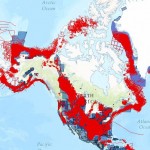
DENVER–petroWEB Inc. today announced Global Seismic Library (GSL) will now be available as a free service via www.globalseismiclibrary.com. GSL is a global catalog of commercial multi-client seismic and gravity/magnetic data coverage.
GeoGeek Interviews via The #GeoGeeksinCars Story Map Journal
It seemed to be a no-brainer idea, watching GeoGeeksinCars via an ArcGIS Story Map! Yep, now you can do just that as the entire collection of GeoGeeksinCars video interviews have been integrated into a Story Map using the Map Journal template. Recall, Story Maps are the easy way to author and share your stories via […]
Esri and USDA Forest Service Introduce Interactive Trove of Maps
Forest Service Opens Data Stores, Improves Forest Management and Public Education
GIS-Expert Ltd. Creates interactive web application that presents the growth of Lublin city
Let’s see how Lublin (a city in Poland) has changed over the last century.
State of Louisiana Saves Lives with Boundless by “Thinking Open”
Louisiana Department of Health and Hospitals Leverages Cost-Effective Open Source Geospatial Strategies to Keep Citizens Out of the Path of Dangerous Storms