The following training will be offered via SimActive for those professionals interested in the combination of LiDAR with imagery – everything LiDAR is trending right now and this webinar subject will interest many!
LiDARUSA Announces Partnership for Galaxy 950 Gas-Electric UAS
LiDARUSA is proud to announce the recent partnership with Innovative Flight and their Galaxy 950 Helicopter UAS.
Headwall & geo-konzept Announce Hyperspectral Remote-Sensing Center in Europe

Center of Excellence in Europe to link airborne hyperspectral & LiDAR technology and applications
Trimble Clarity Now Offered as Web Application for Point Clouds and 3D Models
Easy Sharing Makes 3D Invaluable for Everyone
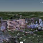
RedTail LiDAR Systems Unveils Innovative 3D Mapping Solution at Commercial UAV EXPO
RTL-400 introduced as high-resolution LiDAR system for small drones
LiDARUSA offers new aircraft to carry full range of UAV scanners
SOMERVILLE, ALABAMA – 23 October 2019 – Based in Somerville, Alabama, LiDARUSA a global leader in the design and integration of economical LiDAR sensors announced a partnership with Innoflight Technology, a manufacturer specializing in UAV systems for surveying, mapping, and inspection. As a result of the partnership, LiDARUSA is offering the Galaxy 950 platform to carry […]
RedTail LiDAR Systems produces amazing corn maze images
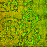
RTL-400 captures precision agriculture at its finest
ILMF & LIDAR Mag Open Nominations for 2020 Lidar Leader Awards

October 21, 2019 (Washington, DC, USA) – International Lidar Mapping Forum and LIDAR Magazine now accepting nominations for the prestigious Lidar Leader Awards.
Mapillary launches a mapping dashcam solution to help logistics companies cut delivery delays by improving maps en-route

New York, October 17—Mapillary, the street-level imagery platform that uses computer vision to scale and automate mapping, just launched a dashcam that’s been customized for mapping purposes.
Applanix Releases New POSPac LiDAR Quality Control Tools for UAVs
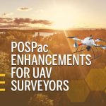
Achieve higher accuracy and reliability when mapping with a UAV using LiDAR