
AerialSphere and iFoundAgent Partner to Provide ‘Addictive’ 360-Degree, Interactive, Immersive Mapping Technology for Websites
Imagery, earth imaging and remote sensing
Satellite Imagery: White Island, New Zealand Volcano

Maxar Technologies collected new satellite imagery on December 11th, of the New Zealand White Island volcano. The imagery provides the first high-resolution satellite imagery that visually documents the aftermath of the eruption that occurred on Monday.
Capella Space Appoints RSI as Marketing Partner in India
RSI expands access to on-demand, very high resolution SAR data for commercial and government customers
Airbus presents ground-breaking technology for EUTELSAT QUANTUM
Madrid, 21 November 2019 – Airbus, ESA and Eutelsat have presented the new ground breaking multibeam active antenna payload today at Airbus in Madrid. Airbus’ ELSA+ (ELectronically Steerable Antenna+) is a first for commercial satellite communications in Europe.
Airbus-built telescope for ESA’s Euclid mission takes shape
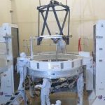
Toulouse, 19 November, 2019 – The Euclid mission is taking shape in Airbus cleanrooms: engineers are now finishing assembly of the telescope, the main instrument of the Payload Module, for which Airbus is responsible within this European Space Agency (ESA) mission led by Thales Alenia Space (TAS) as industrial prime contractor.
Satellite data analytics enable fast and accurate forest inventory sampling in support of natural climate solutions
New Forests, a sustainable forest investment manager, has used Rezatec’s geospatial data analytics to deliver a cost-effective forest inventory to support its US investments in natural climate solutions.
Satellite Imagery: Flooding In Venice, Italy
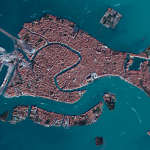
On November 14, Maxar’s GeoEye-1 satellite collected new imagery of Venice, Italy. Floodwaters can be seen across sections of the city, including most notably at St. Mark’s Square (Piazza San Marco) and around the Basilica (Basilica di San Marco).
Airbus checking ocean satellite Sentinel-6A’s operational fitness

Test programme is in full swing – Launch scheduled for November 2020
SOAR ADDS CHINA SIWEI TO ITS GROWING LIST OF SATELLITE IMAGERY PARTNERS
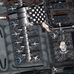
SAN FRANCISCO, USA 30 OCTOBER, 2019 – Digital mapping and imagery company Soar has announced a strategic partnership with the China Siwei Surveying and Mapping Technology Co. Ltd, which falls under the China Aerospace Science and Technology Corporation (CASC).
Maxar Collects satellite imagery of the Kincade fire #California #Wildfire

From Maxar: The Maxar News Bureau has gathered a new set of satellite imagery of the Kincade fire, which continues to burn in northern California near Santa Rosa. The images include sets from October 27th as well as October 30th. As you will see via the imagery, the fire burned very close to the city of […]