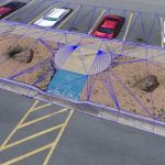
AARSCHOT, Belgium, 2 November 2020 – Virtual Surveyor has introduced Curb & Gutter mapping functionality in Version 7.6 of its popular drone surveying software. The new capability enables surveyors to create a lightweight CAD model of curbs and gutters along the edges of streets and parking lots from standard orthophotos and elevation models captured by unmanned […]
Imagery, earth imaging and remote sensing
Satellite Imagery @Maxar : Southern California’s Blue Ridge and Silverado Wildfires

Maxar Technologies collected new satellite imagery yesterday (October 28th) of the Blue Ridge and Silverado Wildfires that rapidly spread over the past couple of days in southern California, threatening multiple cities including Yorba Linda, Chino Hills and Irvine, California.
GeoSLAM Completes Spook-Tacular Scanning of Californian Landmark

The team at geospatial 3D mapping specialist GeoSLAM has produced a digital twin of one of the world’s most haunted mansions, The Winchester Mystery House, using the newly-launched ZEB Go.
UP42 Partners with Intermap to Bring High-Resolution Elevation Data to UP42’s Geospatial Marketplace

BERLIN, Germany, 27 October 2020 – UP42 is pleased to announce that the NEXTMap Elevation Data Suite from Intermap Technologies is now offered on the UP42 developer platform for Earth observation data and analytics. The NEXTMap 3D elevation products are available as Digital Surface Models (DSM) and Digital Terrain Models (DTM) at one-, five-, and 10-meter […]
Satellite-based Earth Observation Market – Growing Demand for Small Satellites to Boost the Market Growth

LONDON—-The satellite-based earth observation market size is poised to grow by USD 4.51 billion during 2020-2024, according to the latest report by Technavio.
Satellite Imagery: East Troublesome Wildfire Near Rocky Mountain National Park, Colorado

Maxar Technologies collected new satellite imagery (October 22nd) of the East Troublesome Wildfire burning out of control near Rocky Mountain National Park (RMNP) in northern Colorado.
Global Market for Commercial Earth Observation Data and Services to Reach $8 Billion by 2029, Growing from $4.6 Billion in 2019
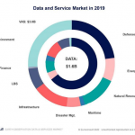
While defense accounted for 64% of the market in 2019, growth will be driven by both defense and commercial market demand, as well as the increase of data from low cost constellations
Hexagon releases Luciad 2020.1, featuring unique dynamic panoramic imagery capabilities
Latest release delivers immersive 3D imagery and experiences
Quantum Spatial Completes Data Collection for NOAA’s Largest Coastal Mapping Project
Unique Combination of Sensors Used to Gather High Resolution Topographic and Bathymetric Lidar Data Along 12,000 Square Miles of Eastern Seaboard and Gulf Coast Areas Not Surveyed Since Civil War Era
UP42 Partners With Hexagon To Offer HxGN Content Program Aerial Imagery on Geospatial Marketplace

BERLIN, Germany, 20 October 2020 – High-resolution aerial imagery from the HxGN Content Program is now available on the UP42 developer platform for Earth observation data and analytics. UP42 customers may now choose from nearly 11 million square kilometers of 30 cm orthorectified imagery for North America and Europe and over 500,000 sq km of 15 […]