PENTAX O-GPS2 provides reliable, high-precision positioning data, simplifies tracing and enables spectacular photography of celestial bodies
PARSIPPANY, N.J., June 8, 2022 /PRNewswire/ — Ricoh Imaging Americas Corporation today announced the PENTAX O-GPS2, a versatile GPS unit designed for use with PENTAX digital SLR cameras* that makes it easy to capture stellar images of the night sky. Developed as a successor to the PENTAX O-GPS1, the PENTAX O-GPS2 provides more reliable and higher-precision positioning data gathered from GPS in the U.S., QZSS in Japan, GLONASS and Galileo.
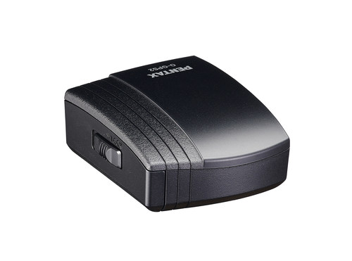
When mounted on a compatible PENTAX digital SLR camera body, the PENTAX O-GPS2 enables the advanced ASTROTRACER function, which couples the unit with the camera’s Shake Reduction (SR) system to facilitate the tracing and photography of celestial bodies. ASTROTRACER allows photographers to shoot longer exposures without star “trails.” The unit calculates the movement of stars, planets, and other bodies using the latitude obtained from the location data and the camera’s alignment data obtained from its magnetic and acceleration sensors, then shifts the camera’s image sensor in synchronization with the movement of the objects. Resulting images show stars and other bodies as solid points rather than blurry streaks, even during extended exposures. It also makes astrophotography much simpler, as it requires only a tripod and eliminates the need for an additional accessory such as an equatorial telescope.
The PENTAX O-GPS2 records the latitude, longitude, altitude, universal time coordinated and direction of shooting location onto captured images. Image files carrying the location data, can be used to track shooting locations and review location data on a PC. The location data stored on such files also makes it much easier to sort and file recorded images.
Other advanced applications offered by the PENTAX O-GPS2 include a simple navigation function, which calculates the direction and distance to a given destination from a current position, and an electronic compass function which displays the camera’s direction on its LCD monitor with great precision.
| Pricing and Availability |
The PENTAX O-GPS2 will be available in late June 2022 at www.us.ricoh-imaging.com as well as at Ricoh Imaging-authorized retail outlets for the manufacturer’s suggested retail price of $179.95.
* Compatible models are the PENTAX K-3 Mark III, KP, K-3, K-5II, K-5IIs, K-5, K-S2, K-S1, K-70, K-50, K-30, K-r, K-01, 645Z, 645D (as of May 2022). All applications will not support all models.
| Main features of the PENTAX O-GPS2 |
1. GPS function for effortless recording of shooting location data The O-GPS2 mounts on the hotshoe of a compatible camera and records the latitude, longitude, altitude, universal time coordinated (UTC) and direction of the shooting location onto captured images. In addition to GPS in the US and QZSS in Japan, GLONASS and Galileo can be newly received.
2. ASTROTRACER simplifies astrophotography When mounted on the corresponding PENTAX digital SLR cameras body, the O-GPS2 also offers the advanced ASTROTRACER function,** which couples the unit with the camera’s SR (Shake Reduction) system for the effortless tracing and photography of celestial bodies. The unit calculates the movement of stars, planets and other bodies using the latitude obtained from the location data and the camera’s alignment data (horizontal and vertical inclinations and aspect) obtained from its magnetic and acceleration sensors, then shifts the camera’s image sensor in synchronization with the movement of the objects.*** In the resulting image, stars and other bodies are captured as solid points rather than blurry streaks, even during extended exposures. It also makes astrophotography much simpler, as it requires only a tripod and eliminates the need for an additional accessory such as an equatorial telescope. In addition to the normal ASTROTRACER: Type 1, ASTROTRACER: Type 2, available only when the O-GPS2 is used with the PENTAX K-3 Mark III, makes the image sensor follow the movement of the celestial body at half the speed of the Type 1. The photographer can suppress the flow of the landscape on the ground and shoot both the stars and the landscape in a well-balanced manner.
** This function is available only when the O-GPS2 is mounted on a PENTAX digital SLR camera body equipped with a SR system.
*** The duration of ASTROTRACER operation may vary depending on photographic conditions.
3. Simple Navigation calculates location data for destinations The O-GPS2 offers a Simple Navigation function, which calculates the direction and distance to a given destination from the current position. The user can either locate destinations using location data stored on recorded images, or register and/or assign them by uploading location data created on a PC.
4. Electronic Compass function indicates and records direction The O-GPS2 comes equipped with an Electronic Compass function, which displays the camera’s direction on its LCD monitor with great precision. Using its magnetic sensor and the location data, the unit indicates the aspect in relation to true north. The user can also record directional data on captured images.
5. Other features
1) Weather-resistant construction for use in light rain.
2) Independent power source (one AAA-size battery) to eliminate the need for power supply from the camera body.
| About Ricoh Imaging Americas Corporation |
Ricoh Imaging Americas Corporation is a subsidiary of Ricoh Company, Ltd. Ricoh is empowering digital workplaces using innovative technologies and services enabling individuals to work smarter. For more than 85 years, Ricoh has been driving innovation and is a leading provider of document management solutions, IT services, commercial and industrial printing, digital cameras and industrial systems. Headquartered in Tokyo, Ricoh operates in approximately 200 countries and regions.
Asahi Optical Joint Stock Co. was founded in 1919 and launched its first SLR camera in the 1950s under the PENTAX name. Over 100 years later, now as part of the Ricoh Group, Ricoh Imaging continues to produce the heritage-rich, award-winning PENTAX line of DSLR cameras, lenses and sport optics equipment. Ricoh’s offering of stylish and compact digital cameras are known for their wide-ranging, unique set of features.
For further information, please visit www.us.ricoh-imaging.com