GIS user technology news

News, Business, AI, Technology, IOS, Android, Google, Mobile, GIS, Crypto Currency, Economics

  • Advertising & Sponsored Posts
    • Advertising & Sponsored Posts
    • Submit Press
  • PRESS
    • Submit PR
    • Top Press
    • Business
    • Software
    • Hardware
    • UAV News
    • Mobile Technology
  • FEATURES
    • Around the Web
    • Social Media Features
    • EXPERTS & Guests
    • Tips
    • Infographics
  • Blog
  • Events
  • Shop
  • Tradepubs
  • CAREERS
You are here: Home / * PRESS / Software / SuperSurv 3.2 Release Advanced GPS Support and Data Collection Functions

SuperSurv 3.2 Release Advanced GPS Support and Data Collection Functions

December 23, 2014 By GISuser

Developed by Supergeo, the latest version of SuperSurv (Android) 3.2 is upgraded with stronger data collecting function by GPS and more precise and easy-to-use GPS manipulation interface, bringing more convenient and intuitive user experience.

SuperSurv is an efficient mobile GIS app designed for field data collection on iOS and Android platforms. The GIS app not only supports users to collect spatial and attribute data, but also provides attribute query, tracklog recording and display, adding Waypoint, etc.

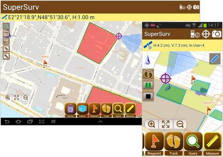
Integrating with GIS and GPS technologies, SuperSurv provides useful functions like Map Display, Query, Measure, etc., and supports to overlay OpenStreetMap as the basemap. Also, users may capture point, line and polygon features and attribute data, and save the data as SHP or GEO format in both offline and online modes.

The new SuperSurv 3.2 has enhanced GPS status bar to show the positioning information with more details like Horizontal Accuracy, Vertical Accuracy and Current Satellite Numbers. Moreover, data collecting function with GPS has been strengthened to provide better positioning efficacy and more accurate data collect settings.

One of the most important inclusions in the new release is the real-time NMEA information for advanced usage, which allows SuperSurv 3.2 users to view or save the GPS records correctly.

To download newest SuperSurv 3.2 free trial

AppStore:
https://itunes.apple.com/us/app/supersurv/id734191604?mt=8

GooglePlay:
https://play.google.com/store/apps/details?id=com.supergeo.asd.supersurv_lite.SuperSurv

Learn More about SuperSurv 3.2
http://www.supergeotek.com/ProductPage_SuperSurv.aspx


Filed Under: Software Tagged With: SuperSurv

Editor’s Picks

Data Tip – The US Interagency Elevation Inventory

Yellowstone’s Thermal Springs — Their Colors Unveiled

Map of the Day – TheCeliacScene, Guides for the Gluten Free

Location Privacy and What you Might be Sharing Over Public WiFi

See More Editor's Picks...

Recent Industry News

Why Adults Are Trimming Their Routines for Travel and Busy Weeks

June 10, 2026 By GISuser

Top Benefits of AI Video Surveillance for Businesses and Public Spaces

June 5, 2026 By GISuser

How to Choose the Best Office Interior Designers in Delhi for End-to-End Projects

June 3, 2026 By GISuser

Why Bathroom Renovation Services Often Change More Than Just the Bathroom

May 20, 2026 By GISuser

Hot News

State of Data Science Report – AI and Open Source at Work

HERE and AWS Collaborate on New HERE AI Mapping Solutions

Virtual Surveyor Adds Productivity Tools to Mid-Level Smart Drone Surveying Software Plan

Categories

Copyright gletham Communications 2015 - 2026

Go to mobile version