GIS user technology news

News, Business, AI, Technology, IOS, Android, Google, Mobile, GIS, Crypto Currency, Economics

  • Advertising & Sponsored Posts
    • Advertising & Sponsored Posts
    • Submit Press
  • PRESS
    • Submit PR
    • Top Press
    • Business
    • Software
    • Hardware
    • UAV News
    • Mobile Technology
  • FEATURES
    • Around the Web
    • Social Media Features
    • EXPERTS & Guests
    • Tips
    • Infographics
  • Blog
  • Events
  • Shop
  • Tradepubs
  • CAREERS
You are here: Home / Mobile GIS, GPS and Location Services (LBS) / GIS Application Story – Engeluz SGIP-Mobile

GIS Application Story – Engeluz SGIP-Mobile

July 10, 2012 By Editor


Engeluz, an electrical engineering company in Brazil, mainly provides local governments with the services and solutions to help maintain and preserve the government properties. Moreover, Engeluz develops the Public Lighting Management Plan, and a mobile GIS system with GPS function would be useful and necessary to improve the efficiency of managing public lighting facilities.

 
Goals

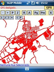
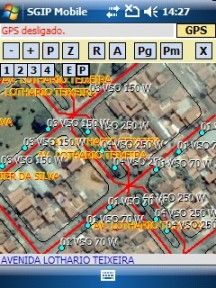
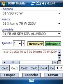
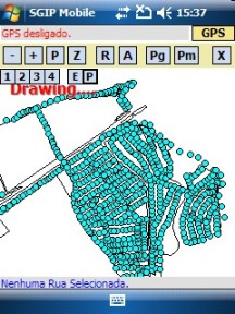
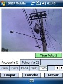
In the Public Lighting Management Plan, Engeluz would need to offer the methods to monitor, maintain, supervise, and plan the Public Lighting System. Thus, a mobile GIS system would be required to help the local government to know the locations of the public lights, the energy consumption, and plan maintaining, and optimize the use of materials and resources. Therefore, the mobile GIS system should not only contain the basic GIS manipulation functions but include camera function that would be quite helpful for surveyors to record the relevant data.

 
Solutions

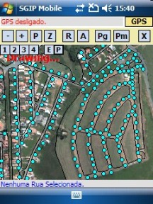
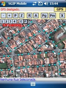
To establish a mobile GIS system to meet the requirements, Engeluz adopts SuperGIS Mobile Engine 3 to develop Engeluz SGIP-Mobile that enables government staff to collect the field data through the mobile devices, like PDA.

SuperGIS Mobile Engine 3 is a mobile GIS SDK. The high flexible development structure, nearly 100 out-of-the-box toolbar buttons, and development sample instruction assist developers in developing intuitive mobile GIS applications. In addition, SuperGIS Mobile Engine 3 allows developers to deploy applications on a large scale; thus, it is useful and economical for developers to deploy the applications to a large number of mobile devices.


Results
To provide the government staff with a helpful mobile GIS system to manage the public lighting facilities, Engeluz developed Engeluz SGIP-Mobile by using SuperGIS Mobile Engine 3. The main functions of Engeluz SGIP-Mobile include, Basic GIS Manipulation, Data Collection, GPS Positioning, Measurement, and Camera Function.
1. Basic GIS manipulation:
Engeluz SGIP-Mobile allows users to add and overlay vector data and raster data, zoom in/out the map, etc.
 
2. Data Collection
Engeluz SGIP-Mobile allows users to add and overlay vector data and raster data, zoom in/out the map, etc.
 
3. GPS Positioning
to accurately record the status of the public lighting facility, Engeluz SGIP-Mobile enables users to apply GPS function to record the position of the facility.
 
4. Measurement
Engeluz SGIP-Mobile provides the measurement function for users to measure the distance and area on the map.
 
5. Camera Function
Besides GPS function, Camera Function is also necessary tool for field surveyors to record the status of the facilities.


With the complete GIS and GPS functions of Engeluz SGIP-Mobile developed with powerful SuperGIS Mobile Engine 3, the field surveyors can directly navigate the large quantities of spatial data on mobile devices rather than return to their office to download or upload. Therefore, the government staffs are able to manage and record the status of the public facilities more efficiently and effectively. The field surveyors can record the current status of the lighting facilities by adding attribute data, taking pictures, and adding annotations. Additionally, the data recorded in vector data, such as GEO file and Shapefile, can be directly displayed on Desktop GIS, like SuperGIS Desktop 3, without any conversion. As a result, it definitely provides the government with a much more convenient and easier way to manage facilities.


Filed Under: Mobile GIS, GPS and Location Services (LBS) Tagged With: Articles, GIS Application Story - Engeluz SGIP-Mobile, GPS and Location Services (LBS), Mobile GIS

Editor’s Picks

Data Tip – The US Interagency Elevation Inventory

Event Review, Commercial Drone Expo

DigitalGlobe Top Images from 2014 – The fourth annual Top Image contest

Introducing the new, HP Z Series Workstation Portfolio – Event recap, images, video and key numbers

See More Editor's Picks...

About Editor

Glenn is a geographer and a GIS professional with over 20 years experience in the industry. He's the co-founder of GISuser and several other technology web publications.

Recent Industry News

The Drift Between Early Notes and Final Case Files in Abuse-Related Legal Support

April 29, 2026 By GISuser

Aerial Surveys Int’l and Global Marketing Insights to Present GEOINT 2026 Workshop on Multi-Domain Geospatial Fusion for Automated Infrastructure Monitoring

April 24, 2026 By GISuser

Why Timing Matters More Than You Think With Spray Seal (And Why People Often Get It Slightly Wrong)

April 22, 2026 By GISuser

The Quiet Planning Stage Most People Don’t See When Building a Pool in Brisbane

April 22, 2026 By GISuser

Hot News

State of Data Science Report – AI and Open Source at Work

HERE and AWS Collaborate on New HERE AI Mapping Solutions

Virtual Surveyor Adds Productivity Tools to Mid-Level Smart Drone Surveying Software Plan

Categories

Copyright gletham Communications 2015 - 2026

Go to mobile version