GIS user technology news

News, Business, AI, Technology, IOS, Android, Google, Mobile, GIS, Crypto Currency, Economics

  • Advertising & Sponsored Posts
    • Advertising & Sponsored Posts
    • Submit Press
  • PRESS
    • Submit PR
    • Top Press
    • Business
    • Software
    • Hardware
    • UAV News
    • Mobile Technology
  • FEATURES
    • Around the Web
    • Social Media Features
    • EXPERTS & Guests
    • Tips
    • Infographics
  • Blog
  • Events
  • Shop
  • Tradepubs
  • CAREERS
You are here: Home / News / Mobile Technology / Full-functionality Mobile GIS—SuperPad 3.1a Now Available

Full-functionality Mobile GIS—SuperPad 3.1a Now Available

October 8, 2013 By Editor

Supergeo is delighted to announce that the latest full-functionality mobile GIS, SuperPad 3.1a, is now released. 

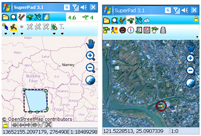
SuperPad is a full-functionality mobile GIS significantly designed for field mapping applications. Field surveyors can apply the system on a variety of mobile devices or handheld devices to collect, edit or measure spatial data, contributing great enhancement on data validity and usability.

Several add-ons are added in SuperPad 3.1a to strengthen the acquisition and convenience, helping field surveyors collect data. Online Map Tool add-on allows users to use OpenStreetMap as a base map to conduct field survey, which saves time on base map preparation. Moreover, SuperPad 3.1a supports GPS satellite add-on, showing the GPS signals information on the interface simultaneously. In manipulation and editing, SuperPad 3.1a now is able to measure features. Besides, the connection with SuperGIS Server and online editing has been better improved as well.

To optimize the accuracy of collected data, GNSS driver, an in add-on is provided in SuperPad 3.1a, assisting recording satellite signals information when users are collecting spatial data. After that, users can add the collected data to SuperGIS Desktop 3.1a and post-process it with Differential GPS add-on so that the accuracy of spatial data can be greatly improved. 

SuperPad 3.1a is launched globally; PC edition can be manipulated on Windows 8. As to the product news and software trial, please visit Supergeo website http://www.supergeotek.com/ProductPage_SP3.aspx or email us staff@supergeotek.com.


Filed Under: Mobile Technology Tagged With: Full-functionality Mobile GIS—SuperPad 3.1a Now Available, Select Category, Select Section

Editor’s Picks

Feature – Oil and Water: Mapping the South China Sea

Dev Tip- The JavaScript Anthology: 101 Essential Tips, Tricks & Hacks

A Decade of Change in America’s Arctic: New Land Cover Data Released for Alaska

Aibot X6 uses Leica Nova MultiStation for accurate geospatial data without GNSS

See More Editor's Picks...

About Editor

Glenn is a geographer and a GIS professional with over 20 years experience in the industry. He's the co-founder of GISuser and several other technology web publications.

Recent Industry News

Why Bathroom Renovation Services Often Change More Than Just the Bathroom

May 20, 2026 By GISuser

The Drift Between Early Notes and Final Case Files in Abuse-Related Legal Support

April 29, 2026 By GISuser

Aerial Surveys Int’l and Global Marketing Insights to Present GEOINT 2026 Workshop on Multi-Domain Geospatial Fusion for Automated Infrastructure Monitoring

April 24, 2026 By GISuser

Why Timing Matters More Than You Think With Spray Seal (And Why People Often Get It Slightly Wrong)

April 22, 2026 By GISuser

Hot News

State of Data Science Report – AI and Open Source at Work

HERE and AWS Collaborate on New HERE AI Mapping Solutions

Virtual Surveyor Adds Productivity Tools to Mid-Level Smart Drone Surveying Software Plan

Categories

Copyright gletham Communications 2015 - 2026

Go to mobile version