Markham, Harwell 23/10/2024 — CATALYST, a PCI Geomatics Enterprise Inc. brand and leader in Earth observation solutions with over 40 years of industry experience has launched INSIGHTS 2.0, a groundbreaking, first-of-its-kind, visualization platform designed to integrate and interpret data from multiple sources. Designed to reshape decision making in critical sectors such as mining, wildfire management and flood monitoring, INSIGHTS 2.0 delivers unprecedented clarity and operational intelligence by fusing satellite imagery with ground-based data, empowering decision-makers to act quickly.
“INSIGHTS 2.0 represents a significant leap forward in our ability to visualize and understand complex geospatial data.” says June McAlarey, President & CEO of PCI Geomatics. “By combining data from various sources, including satellite imagery and ground-based sensors, we’re providing a comprehensive view that is unparalleled in the market and previously difficult to achieve operationally.”
The platform includes a new visualization layer that integrates Earth observation data from multiple sources, using a custom-designed interface for intuitive data comparison and analysis. Based on extensive user feedback, INSIGHTS 2.0 enables spatial and temporal comparisons to be done for more than one dataset at a time using intuitive displays and charting. Among other key innovations planned for release include enabling a 3D mapping capability, which will provide immersive visualization for realistic scenario planning and operational management, allowing asset owners, operators and other end users to better understand operational risks and make recommendations for mitigating action.
CATALYST INSIGHTS 2.0 PLATFORM
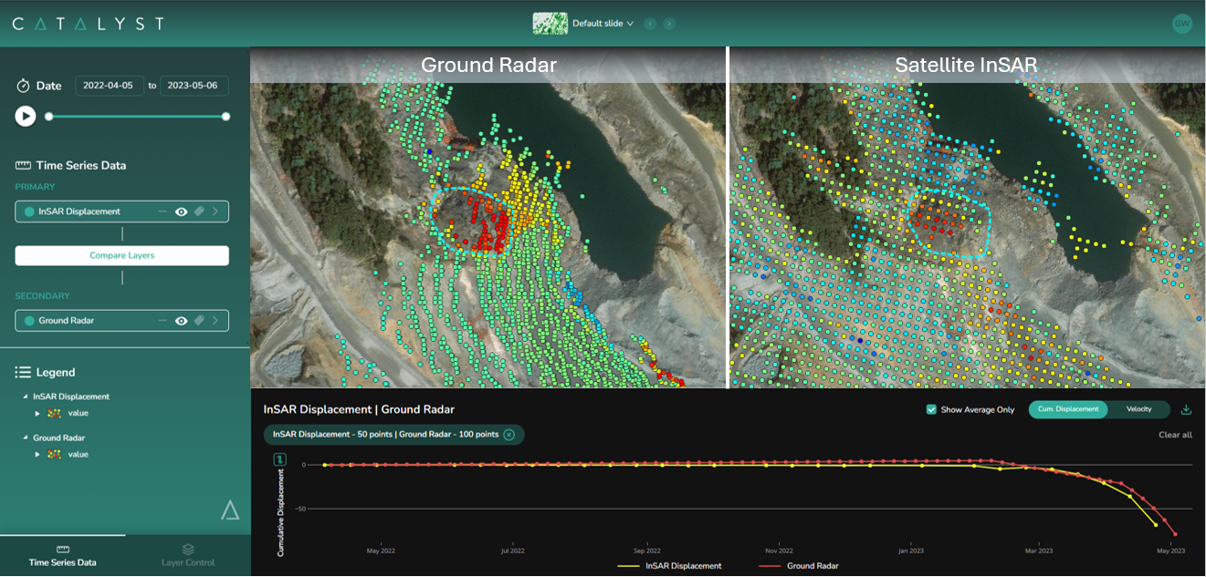
INSIGHTS 2.0 has applications in the mining sector, with its ability to enable operators to pinpoint specific locations for precise measurements through satellite enabled InSAR; in addition, its capabilities are extended with its versatility working across various industries to manage ground displacement, vegetation encroachment, and environmental monitoring.
“INSIGHTS 2.0 represents a significant industry breakthrough, combining InSAR data with a single, intuitive platform.” added Peter Saunders, Director, DigitalTwin Geotechnical “This solution simplifies complex data integration, enhancing user experience. DigitalTwin Geotechnical is excited to offer this cutting-edge functionality to shared clients as INSIGHTS 2.0 sets a new benchmark for geotechnical monitoring, redefining industry best practice, particularly in TSF monitoring.”
With the growing frequency of natural disasters and increasing demand for sustainability throughout industries, INSIGHTS 2.0 comes at a crucial time. The ability to offer a clear and comprehensive view of vast geographical areas is unmatched, enabling faster response times and reducing operational costs in the face of urgent challenges.
INSIGHTS 2.0 is now available through CATALYST’s global channels. For more information about INSIGHTS 2.0 or to schedule a demo, contact CATALYST at sales@catalyst.earth
About CATALYST
CATALYST is a PCI Geomatics brand that delivers scalable business solutions using the power of Earth Observation (EO) data and analytics. We work closely with our clients to implement business friendly solutions that allow decision makers to make more informed and faster decisions about their assets, operations, risk, and sustainability efforts.
