US High School and Middle School Students Used GIS Technology to Map Home State Issues
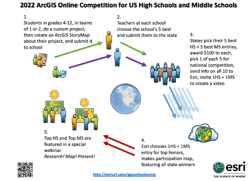
REDLANDS, Calif.–(BUSINESS WIRE)–Students in schools across the nation have continued to achieve despite the unprecedented challenges over the past year as a result of COVID-19. Many of them are using geospatial technology to take a geographic approach toward exploring new subjects. In support of this, Esri, the global leader in location intelligence, each year holds the ArcGIS Online Competition for US High Schools and Middle Schools. For the 2022 competition, two winners and three honorable mentions were chosen from over 500 high school and middle school entries. Participating states awarded $100 to the five best high school (grades 9–12) and five best middle school (grades 4–8) projects in their state.
“Our investment in programs that help equip youth with GIS tools and techniques is one way for us to foster a sense of geographic curiosity and to encourage the next generation of scientific problem solvers.”
“Because young people today are digital natives, they are natural early adopters of new information technologies,” said Jack Dangermond, Esri founder and president. “Our investment in programs that help equip youth with GIS tools and techniques is one way for us to foster a sense of geographic curiosity and to encourage the next generation of scientific problem solvers.”
For the competition, students created and submitted original ArcGIS map projects inspired by their home states. Hannah Osborne won the high school competition with Standing Alone, and Maya Trutschl’s project, The Unexpected Modernism of the South, won the middle school competition. The high school honorable mention went to Taylor Peterson for Lead Exposure in Baltimore and Chloe Hackbart with Cariena Murray for From Dirt to Soil. The middle school honorable mention was awarded to Caden Baum for Mapping to Make a Difference.
The competition gives students an extra opportunity to use Esri’s GIS software, which is offered for free for instructional use to every K–12 school. Students—working alone or in teams of two—complete a custom project about a topic in their state where they gather, create, analyze, interpret, and present data via an ArcGIS StoryMaps story. Students choose and construct their own story and assemble key background information while building skills for college and serving their community.
The ArcGIS Online Competition for US High Schools and Middle Schools began after Minnesota ran a successful state-based competition in 2016, encouraging Esri to use the model nationally. This year’s winners presented their maps during the competition webinar on June 16, 2022, which also included interviews and analysis.
To learn more, visit the 2022 competition, which includes links to projects by all awardees.
About Esri
Esri, the global market leader in geographic information system (GIS) software, location intelligence, and mapping, helps customers unlock the full potential of data to improve operational and business results. Founded in 1969 in Redlands, California, USA, Esri software is deployed in more than 350,000 organizations globally and in over 200,000 institutions in the Americas, Asia and the Pacific, Europe, Africa, and the Middle East, including Fortune 500 companies, government agencies, nonprofits, and universities. Esri has regional offices, international distributors, and partners providing local support in over 100 countries on six continents. With its pioneering commitment to geospatial information technology, Esri engineers the most innovative solutions for digital transformation, the Internet of Things (IoT), and advanced analytics. Visit us at esri.com.