GIS user technology news

News, Business, AI, Technology, IOS, Android, Google, Mobile, GIS, Crypto Currency, Economics

  • Advertising & Sponsored Posts
    • Advertising & Sponsored Posts
    • Submit Press
  • PRESS
    • Submit PR
    • Top Press
    • Business
    • Software
    • Hardware
    • UAV News
    • Mobile Technology
  • FEATURES
    • Around the Web
    • Social Media Features
    • EXPERTS & Guests
    • Tips
    • Infographics
  • Blog
  • Events
  • Shop
  • Tradepubs
  • CAREERS
You are here: Home / * PRESS / Environment / Maxar Satellite Imagery of Crew Dragon 2 and Falcon 9 at Cape Canaveral

Maxar Satellite Imagery of Crew Dragon 2 and Falcon 9 at Cape Canaveral

April 23, 2021 By Editor

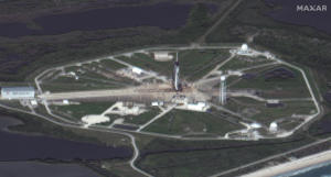
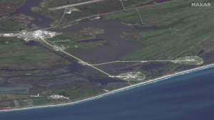
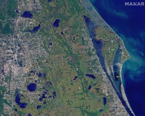
Maxar’s WorldView-3 satellite collected new imagery this morning (April 22nd at 11:13 AM, Eastern) of the Kennedy Space Center ahead of tomorrow morning’s SpaceX Falcon 9 launch with the Crew Dragon capsule that will carry four astronauts into orbit and a journey to the International Space Station (ISS).

Dragon 2 and Falcon 9

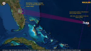
WorldView-3 was flying high over the Atlantic Ocean and looking from a vantage point of nearly 960 miles to the east of Cape Canaveral when it collected this morning’s imagery of the Florida space coast.

Satellite image ©2021 Maxar Technologies

Keywords:  Maxar, Launch Pad 39A, Falcon 9 rocket, Dragon spacecraft, WorldView-3

Filed Under: Earth Imaging - Remote Sensing, Environment Tagged With: maxar

Editor’s Picks

How Safe is Google Wallet?

How Safe is Google Wallet?

Blue Marble Announces Advanced LiDAR Option for the Global Mapper SDK

Mapping Water Use: Landsat and America’s Water Resources

3D Printed Parts for Drones

See More Editor's Picks...

About Editor

Glenn is a geographer and a GIS professional with over 20 years experience in the industry. He's the co-founder of GISuser and several other technology web publications.

Recent Industry News

Aerial Surveys Int’l and Global Marketing Insights to Present GEOINT 2026 Workshop on Multi-Domain Geospatial Fusion for Automated Infrastructure Monitoring

April 24, 2026 By GISuser

Why Timing Matters More Than You Think With Spray Seal (And Why People Often Get It Slightly Wrong)

April 22, 2026 By GISuser

The Quiet Planning Stage Most People Don’t See When Building a Pool in Brisbane

April 22, 2026 By GISuser

Best Equipment Labels for Industrial Use: Ranked Systems That Survive Real-World Conditions

April 17, 2026 By GISuser

Hot News

State of Data Science Report – AI and Open Source at Work

HERE and AWS Collaborate on New HERE AI Mapping Solutions

Virtual Surveyor Adds Productivity Tools to Mid-Level Smart Drone Surveying Software Plan

Categories

Copyright gletham Communications 2015 - 2026

Go to mobile version