GIS user technology news

Mobile, Technology, and Business news

  • PRESS
    • Submit PR
    • Top Press
    • Business
    • Software
    • Hardware
    • UAV News
    • Mobile Technology
  • FEATURES
    • Around the Web
    • Social Media Features
    • EXPERTS & Guests
    • Tips
    • Infographics
  • Events
  • CAREERS
  • Advertise
    • Advertise
    • Meet the Editor
    • Submit Press
  • Shop
  • Tradepubs
  • facebook
  • Around the Web
You are here: Home / * PRESS / LiDAR / Velodyne Lidar to Present Breakthrough Technology for Autonomy and Driver Assistance at Consumer Electronics Show (CES) 2019

Velodyne Lidar to Present Breakthrough Technology for Autonomy and Driver Assistance at Consumer Electronics Show (CES) 2019

January 5, 2019 By GISuser

ESLAS VEGAS–In advance of CES, Velodyne Lidar, Inc. today introduced trailblazing technology that will serve as the cornerstone of future advanced driving safety systems. The new products strengthen Velodyne’s position as the industry leader in providing the smartest, most powerful lidar solutions for vehicle autonomy and driver assistance.

Velodyne Lidar to Present Breakthrough Technology

Velodyne unveiled the VelaDome™, a compact embeddable lidar that provides an ultra-wide 180° x 180° image for near-object avoidance. Velodyne also introduced Vella™, breakthrough software that establishes its directional view Velarray™ lidar sensor as an integral component for advanced driver assistance systems (ADAS).

“With these new products, Velodyne’s robust solution portfolio meets the entire range of lidar needs for autonomy and driver assistance,” said Anand Gopalan, Ph.D., Chief Technology Officer (CTO) at Velodyne Lidar. “David Hall first deployed vehicle software in 2004 as part of the DARPA Challenges. Over the last 15 years, Velodyne has continued to add intelligence to our sensors, enabling a variety of lidar sensing capabilities that allow our customers to detect more objects and offer cars a more detailed view of their surroundings. Now we will take it even further and our new software, which was developed in close collaboration with our lidar hardware experts, will enable a seamlessly integrated ADAS solution powered by our lidars.”

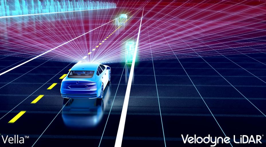
The Lidar Assistant (Vella): Software that Revolutionizes ADAS Performance

Velodyne presented a groundbreaking advanced driver assistance solution that builds upon its directional view Velarray sensor. Vastly superior to existing approaches that utilize camera+radar, this solution will revolutionize advanced driver assistance functionalities currently on the market, such as Lane Keeping Assist (LKA), Automatic Emergency Braking (AEB), and Adaptive Cruise Control (ACC).

VelaDome: Close-Range Precision

The VelaDome’s game-changing hemispherical field of view and high-density image present a quantum leap in pedestrian, cyclist, and blind-spot detection. The compact sensor is ideal for a variety of mounting and styling options. Powered by Velodyne’s patented Micro Lidar Array (MLA) technology, the VelaDome is optimized for manufacturability and designed to meet automotive-grade standards. Like all Velodyne sensors, VelaDome has world-class technical support available across North America, Europe, and Asia.

For more information on Velodyne and to download news releases, photos, and videos, please visit https://velodynelidar.com/newsroom/. Media can schedule an executive interview or product demo by contacting Robin Carr at Landis Communications Inc. (415-971-3991; velodyne@landispr.com).

About Velodyne Lidar

Velodyne provides the smartest, most powerful lidar solutions for autonomy and driver assistance. Founded in 1983 and headquartered in San Jose, Calif., Velodyne is known worldwide for its portfolio of breakthrough lidar sensor technologies. In 2005, Velodyne’s Founder and CEO, David Hall, invented real-time surround view lidar systems, revolutionizing perception and autonomy for automotive, new mobility, mapping, robotics, and security. Velodyne’s high-performance product line includes a broad range of sensing solutions, including the cost-effective Puck™, the versatile Ultra Puck™, the perfect for L4-L5 autonomy Alpha Puck™, the ultra-wide angle VelaDome™, and the ADAS-optimized Velarray™

Filed Under: LiDAR Tagged With: CES, lidar


Editor’s Picks

ArcGIS Online Updates Include Smart Mapping and More

ArcGIS Online Updates Include Smart Mapping and More

Real Earth™ Wins Microsoft Competition for 3D Mapping and Localization

ESRIUC Notes – Top 10 new features in ArcGIS 10.2

#DevSummit Video – A First Look at Drone2Map for ArcGIS

See More Editor's Picks...


GIS jobs


Recent Features

Photographer Touch Reveal the Top Cameras, Lenses, and Photo Editing Tools of 2022

Digitalization and Simulation at the North Pole

Natural Gas District & GIS-Centric Asset Management

5 Ways Technology Is Affecting The Sharing Economy

Spotlight – Township Canada: Explore Canadian Legal Land Descriptions on a Map

More Posts from this Category


Post your link here!

Categories

Recent Posts

  • Will AI be the future of digital entertainment?
  • 5 Common Mistakes with Designing an Infographic and How to Avoid Them
  • How You Can Use Technology to Make Online Deliveries Easier
  • Choosing the Right Mobile Phone in Nigeria
  • The Soaring Popularity of Online Gaming

RSS Career Tips

  • Four Characteristics of the Best Virtual Employees
  • 28 Tools to Conquer the Social Media Recruiting World
  • 8 Questions Employers Should Ask About Coronavirus
  • Jobcase Launches Free Unemployment Resource Center for Workers Impacted by COVID-19
  • Must-Have Gadgets and Technology for the Remote Office Worker


shop for geogeek swag


RSS Tech pubs

  • This Is Your Captain Speaking
  • Display Advertising in 5 Charts
  • Accelerating Continuous Modernization with Low-Code

RSS Computers

  • How the Cloud is Reshaping Virtual Desktops
  • Millennials as Brand Advocates - New Research Study Results
  • Vehicles Best Practices Installation Guide

RSS HR Tips

  • Is Your Field Solution Configurable to Meet Your Telecom Operation Needs?
  • Digitize Telecom Field Operations for First-Issue Resolution, Every Time
  • 3 Ways to Enhance Your Telecom Team's Service Proposition

RSS Gov Tech

  • The State of the CDP 2023
  • State of the CDP 2023
  • Read: 2023 State of the CDP

RSS UAV news

  • Liverpool welcomes Eurovision with record-breaking drone show by Celestial and Drone show Technology
  • Esri Partner Pollen Systems Provides Advanced Agriculture Analytics to Farms using PrecisionView™ Mobile
  • Draganfly Fulfills Delivery of First Situational Assessment Drone for DSNS Emergency Services Department Ukraine

RSS Geojobs

  • IT Endpoint Technician
  • Systems Administrator
  • Senior Systems Administrator
Copyright gletham Communications 2011-2022

Go to mobile version