GIS user technology news

News, Business, AI, Technology, IOS, Android, Google, Mobile, GIS, Crypto Currency, Economics

  • Advertising & Sponsored Posts
    • Advertising & Sponsored Posts
    • Submit Press
  • PRESS
    • Submit PR
    • Top Press
    • Business
    • Software
    • Hardware
    • UAV News
    • Mobile Technology
  • FEATURES
    • Around the Web
    • Social Media Features
    • EXPERTS & Guests
    • Tips
    • Infographics
  • Blog
  • Events
  • Shop
  • Tradepubs
  • CAREERS
You are here: Home / * PRESS / Software / Orbit GT releases UAS Mapping v17.1 with Cloud Upload feature at UAV Expo, Brussels

Orbit GT releases UAS Mapping v17.1 with Cloud Upload feature at UAV Expo, Brussels

June 20, 2017 By GISuser

Orbit GT releases v17.1 of its UAS Mapping desktop product including the all-new Upload to the Cloud feature.  It is available for download today from our website www.orbitgt.com.

2017-06-20 19_11_02-PR 2017-06-16 Orbit GT - Orbit GT releases UAS Mapping v17.1 with Cloud Upload f

“This upgrade includes the capability to upload any UAS Mapping content directly to www.3dmapping.cloud, our SaaS based sharing and collaboration platform”, says Peter Bonne, CEO of Orbit GT. “It adds a great new feature for everyone collecting and creating drone based content.”

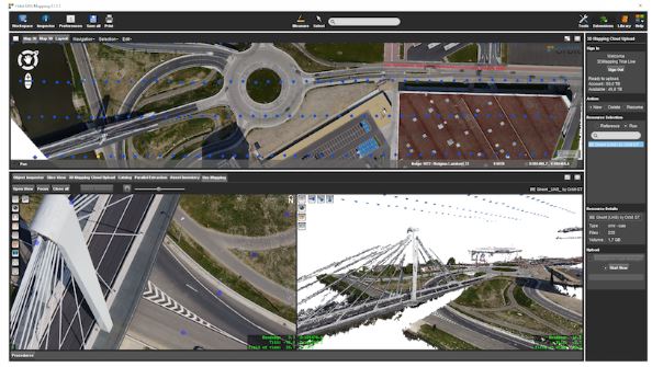
‘Upload to the Cloud’ allows for users to instantly bring their drone/UAS/UAV data online.  The upload process is fluently integrated in the known workflows of the product, with the required checks and validations.  Upload time depends on your internet connection.  Once uploaded, the data is immediately available for sharing on www.3dmapping.cloud.  The new Catalog tool adds insight and overview of all data collection jobs done, indispensible to manage large jobs.

This product is available for download today on www.orbitgt.com . This update is free for holders of a license with maintenance.

Visit us at UAV Expo Europe, Brussels, June 20-22, at The Square ( www.squarebrussels.com )

About Orbit GeoSpatial Technologies

Orbit Geospatial Technologies is world leader in solutions for exploiting 3D Mapping content in managing, viewing, extracting, publishing, sharing and embedding in workflows, either desktop or cloud based. Orbit GT specializes in 3D Mapping solutions for Mobile Mapping, UAS Mapping, Indoor Mapping and Aerial Oblique Mapping, replacing the big data dilemma with ease of use. Orbit GT is headquartered in Lokeren, Belgium, and enjoys a global business network.

www.orbitgt.com

Filed Under: Software Tagged With: cloud, Orbit GT

Editor’s Picks

Internet of Things for Defense & National Security

HERE Beta Will Challenge Your Google Maps Loyalty

Prestigious Award Win For Local Crowd Funded Start Up Business

First Look – Los Angeles Opens the GeoHub – #OpenData for Citizens and Developers

See More Editor's Picks...

Recent Industry News

How Enterprises Are Using AI to Automate 80% of Customer Interactions With Voice Agents

June 16, 2026 By GISuser

Why On Cloud Shoes Are Worth the Price in Mexico

June 16, 2026 By GISuser

Jinghong vs XAG Agricultural Drones: A Comprehensive Comparison Guide

June 16, 2026 By GISuser

Why Adults Are Trimming Their Routines for Travel and Busy Weeks

June 10, 2026 By GISuser

Hot News

State of Data Science Report – AI and Open Source at Work

HERE and AWS Collaborate on New HERE AI Mapping Solutions

Virtual Surveyor Adds Productivity Tools to Mid-Level Smart Drone Surveying Software Plan

Categories

Copyright gletham Communications 2015 - 2026

Go to mobile version