GoodLands Uses Cutting-Edge Spatial Analysis to Launch Global Environmental and Social Change Initiative
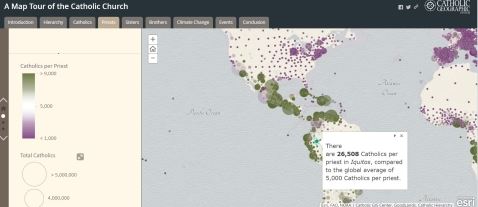
Global Map of the Catholic Church
REDLANDS, Calif.-Global smart-mapping leader Esri today announced that the GoodLands project team has partnered with Esri to create a digital map portal of the Catholic Church’s global landholdings
The project uses geographic information system (GIS) technology from Esri to inspire the world’s 1.2 billion Catholics to take a more ecological approach toward managing church land. GoodLands also assists nonprofit Catholic aid organizations in using spatial information to address global problems that include poverty and climate change.
“We are thrilled to partner with Esri on this initiative,” said Molly Burhans, executive director of the GoodLands project. “GIS is the tool that enables a holistic perspective to solve problems sustainably. Using Esri’s technology, we are able to view urgent issues such as extreme poverty, environmental degradation, and climate change; identify where problems are located; and understand the impact on the people in the area. By bringing these issues to light, we hope it will inspire others to take action.”
The GoodLands GIS portal provides comprehensive spatial data to Catholic organizations worldwide that support efforts in conservation, health care, education, and other issues. The portal offers an intuitive user experience: Individuals can contribute information, and organizations can share data, creating a living atlas of information that can be crowdsourced to maintain relevancy and accuracy.
Esri founder and president Jack Dangermond said, “Esri is proud to collaborate with GoodLands on such an important and impactful global initiative. Esri’s technology provides valuable problem-solving tools that allow GoodLands to succeed at doing great work and making significant change worldwide.”
Esri provides the capabilities to create, access, and store the massive amounts of data required to map the church’s landholdings completely and securely. The ability to visualize and analyze this data through easily understandable maps results in a clear view of the global landscape helping decision-makers preserve and protect the land.
Esri has a long history of assisting nonprofit organizations such as GoodLands in serving their communities better with GIS. Learn more about the Esri Nonprofit Organization Program at go.esri.com/pr-goodlands.
About GoodLands
GoodLands’ goal is to help the Catholic Church make her landholdings become a vehicle for positive global environmental and social change through geographic information technologies and community involvement.
About Esri
Since 1969, Esri has been giving customers around the world the power to think and plan geographically. As the market leader in GIS technology, Esri software is used in more than 350,000 organizations worldwide including each of the 200 largest cities in the United States, most national governments, more than two-thirds of Fortune 500 companies, and more than 7,000 colleges and universities. Esri applications, running on more than one million desktops and thousands of web and enterprise servers, provide the backbone for the world’s mapping and spatial analysis. Esri is the only vendor that provides complete technical solutions for desktop, mobile, server, and Internet platforms. Visit us at esri.com/news.
Copyright © 2016 Esri. All rights reserved. Esri, the Esri globe logo, GIS by Esri, esri.com, and @esri.com are trademarks, service marks, or registered marks of Esri in the United States, the European Community, or certain other jurisdictions. Other companies and products or services mentioned herein may be trademarks, service marks, or registered marks of their respective mark owners.
Suggested Tweet:
.@Esri and @Good_Lands parter to create first global map of the Catholic Church #GIS