Springfield, Va. — The National Geospatial-Intelligence Agency and the National Science Foundation publicly released new 3-D topographic maps of Alaska Sept. 1 in support of a White House Arctic initiative to inform better decision-making in the Arctic.
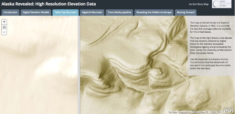
The 3-D digital elevation models, or DEMs, are the first to come from the ArcticDEM project, which was created after a January 2015 executive order calling for enhanced coordination of national efforts in the Arctic.
“To help Alaskans better plan for sustainable development, the National Geospatial Intelligence Agency and the National Science Foundation are leading a public-private collaboration to create the first-ever publicly available, high-resolution, satellite-based elevation map of Alaska by next year and the entire Arctic by the year after that,” said President Barack Obama in his Sept. 3, 2015 remarks at Kotzebue High School.
Models of the entire Arctic are scheduled for release in 2017.
The models are based on 2-meter resolution images captured by Digital Globe commercial satellites. This technology is significant in polar mapping because it allows for more thorough coverage of the Arctic than did traditional imagery collection by aircraft, which is limited in the inhospitable and remote polar region.
“The models will play an important role in informing policy and national security decisions,” said Robert Cardillo, NGA director. “They may also provide critical data and context for decisions related to climate resilience, land management, sustainable development, safe recreation and scientific research.”
The release of high-resolution elevation mapping marks a huge step forward in our ability to deal with the changing Arctic, said Ambassador Mark Brzezinski, Executive Director of the Arctic Executive Steering Committee at the White House.
“The Arctic region is experiencing some of the most rapid and profound changes in the world,” said Brzezinski. “These changes impact communities, as well as the ecosystems upon which they depend. Yet, much of Alaska and the Arctic lack even basic modern and reliable maps to help Arctic communities understand and manage these risks. The DEMs will address this gap.”
The project brings together a unique set of national assets, including the White House Office of Science and Technology Policy, NGA, NSF, the Polar Geospatial Center at the University of Minnesota, University of Illinois, Ohio State University and Cornell University.
Teams from NGA and NSF worked with these partners to launch an unclassified, open Arctic portal where the DEMs and emerging information is available to the public. Esri, a geographic information system provider, hosts the site at nga.maps.arcgis.com. The public website hosts Webmaps, map viewers, other DEM exploratory tools, nautical charts, sailing directions and infographics, and a downloadable Pan-Arctic map with mission-specific data layers.
The U.S. serves as the chair of the Arctic Council through Spring 2017 when the position rotates to Finland for two years.
The White House Arctic Initiative supports efforts to understand the Arctic, engage with residents, and develop tools, products and services that improve federal, state and local activities in the Arctic.
About NGA
NGA delivers world-class geospatial intelligence that provides a decisive advantage to policymakers, warfighters, intelligence professionals and first responders. NGA is a unique combination of intelligence agency and combat support agency. It is the world leader in timely, relevant, accurate and actionable geospatial intelligence. NGA enables the U.S. intelligence community and the Department of Defense to fulfill the president’s national security priorities to protect the nation.
About NSF
NSF is an independent federal agency created by Congress in 1950 “to promote the progress of science; to advance the national health, prosperity, and welfare; to secure the national defense…” With an annual budget of $7.5 billion (FY 2016), NSF is the funding source for approximately 24 percent of all federally supported basic research conducted by America’s colleges and universities. In many fields such as mathematics, computer science and the social sciences, NSF is the major source of federal backing.
About the Polar Geospatial Center
The Polar Geospatial Center at the University of Minnesota is funded through a cooperative agreement with the National Science Foundation to support the collection and dissemination of satellite imagery in support of polar science. Through its partnerships with scientists, NGA, Esri, and the supercomputing center at University of Illinois, PGC coordinates the effort to collect imagery that is transformed into 3-D imagery and linked together to create and disseminate the ArcticDEM to the public.
About Esri
Since 1969, Esri has been giving customers around the world the power to think and plan geographically. The market leader in GIS technology, Esri software is used in more than 350,000 organizations worldwide including each of the 200 largest cities in the United States, most national governments, more than two-thirds of Fortune 500 companies, and more than 7,000 colleges and universities. Esri applications, running on more than one million desktops and thousands of web and enterprise servers, provide the backbone for the world’s mapping and spatial analysis. Esri is the only vendor that provides complete technical solutions for desktop, mobile, server, and Internet platforms. Visit us at esri.com/news.