GISuser.com

GIS and Technology news for mapping professionals

  • PRESS
    • Submit PR
    • Top Press
    • Business
    • GIS, Geo Tech Software
    • Hardware
    • UAV News
    • Mobile Technology
    • Editor’s Top Picks
    • Get TOP Listing!
  • FEATURES
    • GeoGeeksinCars
    • 10 Question Q&A
    • FROM THE EDITOR
    • SPATIAL MEDIA AUTHORS
    • Social Media Features
    • EXPERTS & Guests
    • Listicles and Top 10 Lists
    • Infographics
    • VIDEOS
  • Events
    • Webinars
    • Submit event
    • Event Media Partner
  • CAREERS
    • Career Help Articles
    • People and Career News
    • Work from Home
    • About GeoJobs.BIZ
  • About
    • Advertise
      • Advertise wth GISuser
      • Media Kit Request Form
      • Directory
      • Submit Press
    • Contact GISuser
    • Meet the Editor
    • Social Media
      • AnyGeo Blog
      • GeoGeeks Podcast
      • Social Media Features
      • Like Us
    • SpatialMedia
      • LBSzone
      • LiDAR Magazine
      • Amerisurv
      • SymbianOne
    • RSS feed
  • Blog
  • Shop
  • Cloud Hosting
    • Amazon Cloud Hosting
    • WordPress cloud hosting
    • Dedicated servers USA
    • Linux Shared Hosting
    • Windows Shared Hosting
    • Web Development
    • SSL Certificate
  • Tradepubs
You are here: Home / * PRESS / Business / Social Media is an Increasingly Important Part of Webmaps, Data Analysis, Analytics and Visualizations

Social Media is an Increasingly Important Part of Webmaps, Data Analysis, Analytics and Visualizations

May 27, 2016 By Editor

By searching public posts, the National Geospatial-Intelligence Agency fulfills its duty to provide decision-makers with past, present and future insights into locations during a global emergency. The NGA isn’t the only agency augmenting their data analysis efforts, analysis and mapping with the inclusion of public social media feeds. There are many ways that real-time public data via the crowd, secured from social media, can augment data analysis, mapping and decision making.

social media analysis 
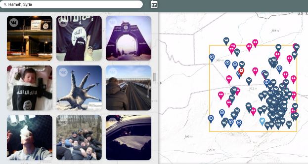
Public Social Media feeds mapped in Syria (Image Credit: DefenseOne)

The following are just a few of the uses for the inclusion of public social data:

Social search supporting TSA activities
Transportation Security Administration moved Kelly Hoggan, chief of U.S. airport security, to another position after outraged flyers posted numerous pictures and videos on social media outlets in recent days showing security lines snaking through airport terminals at a snail’s pace. The analysis of tweets and Instagram posts from frustrated travelers resulted in immediate action to resolve the problem. See More

Weather Forecasting
The USGS employs the use of Twitter to create a Twitter feed and map provide real-time water, weather and flood forecasting for Texas. The Twitter feeds and Texas Water Dashboard can do more than assist residents during flooding. Understanding weather and streamflow can help determine the best places to go boating, fishing or hiking. See More

Medical / Health Tracking
Health professionals have turned to social media to view patterns , hotspots and trends in occurrence of the flu. The flutracker uses big data from the Twitter pipe to see where the flu has been and predict where it is going next – see more Info

Social Media for Fed Background Checks
Federal agencies and background checks – On May 13, 2016, the Office of the Director of National Intelligence (“ODNI”)announced a new policy under which federal agencies may consider publicly available social media information in connection with an application for a security clearance. See more

Track Wildfires Across the Western US with Interactive Esri Maps
View continuously updated information about wildfires and their perimeters from the USGS and other agencies. You can also see live weather warnings and wind information from NOAA, as well as live weather radar from AccuWeather. Get a local perspective on events by turning on geotagged social media from Twitter, YouTube, and Flickr on the Layers tab. See More

Employee Search and Recruiters
Head hunters, recruiters and employers using social media search to seek information about current employees and potential condidates. Reputation search and management via social media has become a widely used tool by HR. See  More

Business use
Social media mapping is just a part of an overall social media strategy. Businesses are constantly using social media to improve, including using it to watch competitors, interact with their current customers and reach new markets. See More

Law Enforcement
A 2013 social media survey from the International Association of Chiefs of Police found that 96 percent of police departments use social media in some capacity, more than 80 percent say it has helped them solve crimes, and 73 percent of agencies said it helped improve police-community relationships in their jurisdiction.  See More

Military Movements
Satellite images, digital detective work and social media provide strongest evidence yet of Russian crossborder shelling, according to investigation via the Guardian. Recall also, last year when the government used Echosec social search service to identify key areas in the Syria conflict.  See More

Conflict and Social Unrest
Back in 2011 Esri was serving a Libya Unrest map application that disseminates information being sent via Twitter, YouTube, and Flickr. The social media layers allow for custom keyword searches. Streetmap, OpenStreetMap, satellite imagery, and topographic maps are part of the map overlay. The public Ushadihi layer shows mapped reports. Additional map layers added as data becomes available. See More

The future of social media in data analysis and big data analytics was discussed in the recently published 2016 State of the Geoint Report. From the report…  “As youth who have never experienced a day without Twitter, Instagram, Snapchat, or Pinterest—who conduct “research” by opening Wikipedia and linking to source documentation and monitor their every activity with Fitbit and Apple Watch—enter the GEOINT workspace, they are radically underwhelmed by available tools, techniques, and processes. For example, newsworthy events are often posted, discussed, and dissected on Twitter before they are even detected in more traditional ways. Thus far, attempts to duplicate open capabilities inside the secure world suffer from the economies of scale the open cloud provides. To fully enable our workforce, true access to all information portals will need to be embraced. If this occurs, then the analyst of 2025 would experience a very different spectrum of activities for information gathering and synthesis.” Source: State of the Geoint report 2016 http://usgif.org/education/StateofGEOINT

How is your organization using social media in your workflows? Share your thoughts with @gletham on Twitter

Suggested Resources:

  • TrendHunter – Social Media Mapping
  • SnapTrends
  • Echosec Location-based search
  • Geofeedia
  • Esri Story Maps
  • Tableau


Related Articles on GISuser:

  • eTERA Consulting to Host Webinar on Social Media and eDiscoveryeTERA Consulting to Host Webinar on Social Media and eDiscovery
  • Feature: Social Media Mapping is Crucial for Market Research and your Social StrategyFeature: Social Media Mapping is Crucial for Market Research and your Social Strategy
  • Meet Echosec at the NALI conferenceMeet Echosec at the NALI conference
  • Social Guide – The Definitive Starting Point for Mastering your Twitter AnalyticsSocial Guide – The Definitive Starting Point for Mastering your Twitter Analytics
  • Echosec named one of Douglas Magazine’s 10 to Watch Award WinnersEchosec named one of Douglas Magazine’s 10 to Watch Award Winners
  • SMi’s 5th annual congress on Social Media within the Defence and Military SectorSMi’s 5th annual congress on Social Media within the Defence and Military Sector

Filed Under: Business, Features of the Month, FrontPage Leader, Government & OpenGov, Maps and Cartography, Social Media Features, THE EDITOR, Top Features, Top Press Tagged With: Big Data, data analysis, GeoINT, Intel, social media


Editor’s Picks

geojobs

GeoJobs.BIZ Employment and Career Resource for GIS, Surveying, and Mapping Professionals

World LiDAR Market is Expected to Reach $921.2 Million by 2022 – Allied Market Research

Aibot X6 uses Leica Nova MultiStation for accurate geospatial data without GNSS

Hardware Spotlight – HP Z240 SFF Turbo Workstation

See More Editor's Picks...

About Editor

Glenn is a geographer and a GIS professional with over 20 years experience in the industry. He's the co-founder of GISuser and several other technology web publications.

Connect with GISuser

  • Facebook
  • Google+
  • LinkedIn
  • RSS
  • Twitter


GIS jobs

Recent Features

Digitalization and Simulation at the North Pole

Natural Gas District & GIS-Centric Asset Management

5 Ways Technology Is Affecting The Sharing Economy

Spotlight – Township Canada: Explore Canadian Legal Land Descriptions on a Map

GeoGeeksinCars – The one in “Tippy” the right-hand drive Mitsubishi, at DevSummit

More Posts from this Category

Categories


Recent Posts

  • Trimble Announces Rugged, Lightweight Field Data Controller for Land and Construction Surveying
  • Webinar – How to Solve Algal Blooms in Municipal Water
  • Concept3D Offers Virtual Tour and Mapping Software to Hospitality and Tourism Industry at No Cost
  • 4 ways to improve your online performance
  • Shock your professor with these essay writing tips

RSS Career Tips

  • Four Characteristics of the Best Virtual Employees
  • Jobcase Launches Free Unemployment Resource Center for Workers Impacted by COVID-19
  • 8 Questions Employers Should Ask About Coronavirus
  • Must-Have Gadgets and Technology for the Remote Office Worker
  • Must-Have Gadgets and Technology for the Remote Office Worker


shop for geogeek swag

RSS Tech pubs

  • Five Signs You've Outgrown Your Accounting System
  • How Does Your Close Perform Against Your Peers?
  • Financials Face-off: On-premise vs. Cloud

RSS Computers

  • iPad CTO Kit - including the iPad Tips and Tricks Guide for IT Executives and Managers
  • The Essentials of Information Security Kit: Includes a Free PC Security Handbook - 2nd Edition eBook
  • Windows... On Speed

RSS HR Tips

  • HSA Spending & COVID-19: How to Adapt Benefits to Healthcare Trends
  • Prevention Cost Savings: What is the ROI for Diabetes Prevention?
  • The ROI of Next-Gen LMS

RSS Gov Tech

  • Cyberwarfare Requires Speed, Adaptability and Visibility to Win: Enterprises Must Close the IT Operations and Security Gap
  • Next-generation Situational Awareness - How Skydio's autonomous drone solutions protect first responders
  • AI Meets Inspection: How Autonomous Drones are Changing the Game in Enterprise

RSS UAV news

  • Global Commercial Drone Market Expected to Exceed $8.5 Billion By 2027
  • Down to Earth – Drone Lidar Surveying Reality Series Returns
  • Florida Signs Participating Addendum with DroneUp Providing Public Sector Agencies Access to Drone Services

RSS Geojobs

  • An error has occurred, which probably means the feed is down. Try again later.
Copyright Spatial Media LLC 2003 - 2015