GIS user technology news

News, Business, AI, Technology, IOS, Android, Google, Mobile, GIS, Crypto Currency, Economics

  • Advertising & Sponsored Posts
    • Advertising & Sponsored Posts
    • Submit Press
  • PRESS
    • Submit PR
    • Top Press
    • Business
    • Software
    • Hardware
    • UAV News
    • Mobile Technology
  • FEATURES
    • Around the Web
    • Social Media Features
    • EXPERTS & Guests
    • Tips
    • Infographics
  • Blog
  • Events
  • Shop
  • Tradepubs
  • CAREERS
You are here: Home / * PRESS / Mobile / Orbit GT launches Mobile Mapping Feature Extraction Bundle at SPAR, Houston.

Orbit GT launches Mobile Mapping Feature Extraction Bundle at SPAR, Houston.

April 4, 2016 By GISuser

Lokeren, Belgium, April 4th, 2016. Orbit GT launches the Mobile Mapping Feature Extraction Bundle at the upcoming SPAR event in Houston, USA.

PR 2016-04-04 Orbit GT - Orbit GT launches new Mobile Mapping Feature Extraction Bundle at SPAR, Houston

“We’re happy to announce the launch of a the 11.2.4 Feature Extraction Bundle, an all-in-one solution for Mobile Mapping services”, says Peter Bonne, CEO of Orbit GT.  “Feature Extraction and the Asset Inventory Bundle have been available for many years.  Now we make the Feature Extraction Bundle available for everyone, including a trial download starting today.”

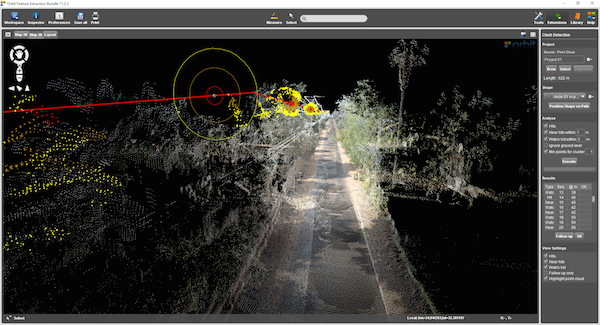
The Feature Extraction Bundle is a stand-alone desktop product that includes Feature Extraction Basic, Asset Inventory, Clash Detection, Profiles & Cross Sections, Volumetric Analysis and Contour Lines in an all-in-one solution. The product is immediately available for download from the orbitgt.com website

About Orbit GeoSpatial Technologies

Orbit Geospatial Technologies is world leader in solutions for exploiting Mobile Mapping, UAS and Aerial Mapping data in managing, viewing, extracting, publishing, sharing and embedding in workflows. Orbit GT is headquartered in Lokeren, Belgium.

For more information, please contact

http://www.orbitgt.com

Filed Under: Mobile, Software Tagged With: Mobile Mapping, Orbit GT

Editor’s Picks

Wider Selection of US Topo Maps From USGS Now Available in Avenza’s PDF Maps App

Social Guide – The Definitive Starting Point for Mastering your Twitter Analytics

NOAA’s Lake Level Viewer of the Great Lakes

Map of the Day – TheCeliacScene, Guides for the Gluten Free

See More Editor's Picks...

Recent Industry News

Best Equipment Labels for Industrial Use: Ranked Systems That Survive Real-World Conditions

April 17, 2026 By GISuser

Building a Global Natural Brand: The Digital Journey of VedaOils

April 15, 2026 By GISuser

DeltaQuad partners with Meridein Group OÜ to strengthen UAS capability in the Baltics

April 15, 2026 By GISuser

The Complete Guide to Improving Home Safety and Efficiency with Dryer Vent Cleaning

April 12, 2026 By GISuser

Hot News

State of Data Science Report – AI and Open Source at Work

HERE and AWS Collaborate on New HERE AI Mapping Solutions

Virtual Surveyor Adds Productivity Tools to Mid-Level Smart Drone Surveying Software Plan

Categories

Copyright gletham Communications 2015 - 2026

Go to mobile version