The architecture, engineering and geospatial firm will provide data and market analysis for Michigan Tech as they continue to test an algorithm that would address transportation safety.
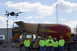
Woolpert has been hired to collect imagery of haul roads throughout the Midwest. The firm will collect the imagery via UAS, or drone.
DAYTON, OHIO MARCH 22, 2016 – Woolpert has been hired by Michigan Tech Research Institute (MTRI) to collect imagery via unmanned aerial system (UAS), or drone, of haul roads throughout the Midwest.
This project, “Characterization of Unpaved Road Conditions Through the Use of Remote Sensing,” is sponsored by the U.S. Department of Transportation (USDOT), Office of the Assistant Secretary for Research and Technology (OST-R).
The data collected will help test a set of algorithms developed by MTRI, a branch of Michigan Technological University located in central Michigan.
“The contract is to help commercialize computerized analysis and assessment of unpaved roads,” said Aaron Lawrence, Woolpert GIS expert and UAS technology developer. “Michigan Tech has some algorithms to detect potholes, rutting, damage, etc., through high-resolution imagery and 3D point clouds, which would be used to assess and address unstable roads.”
The UAS is intended to provide a fast, safe and cost-effective collection to better understand where road material is lost and what damage there is to these roads.
“If I’ve got a 25-ton truck on a dirt road, and the road bank is unstable, that would be a safety hazard,” Lawrence said. “The key is identifying these issues before something bad happens.”
Woolpert has been employing UAS for multiple industries that require efficient, remote and highly accurate imagery collections.
In addition to roads projects, the national architecture, engineering and geospatial firm is tasking UAS for oil and gas surveying, site design and civil engineering.
“UAS is ideally suited to smaller, rural sites,” Lawrence said. “It’s safer and it’s more cost-effective than flying individual manned aircraft missions, and in many cases we can turn around the imagery in 24 hours or less.”
Lawrence added that gathering imagery and generating 3D models of construction sites and the unpaved roads that provide access to them helps companies monitor construction, inventory material or simulate runoff scenarios to ensure designated retention ponds are collecting material as designed, instead of the surrounding rivers and streams.
“Post-construction UAS imagery can be very useful because it captures significant change to the area after companies clear and level land, install equipment or build haul roads,” Lawrence said.
Woolpert was the first surveying and aerial mapping company to be approved to fly a UAS commercially in designated airspace, earning an FAA Section 333 Exemption in December 2014.
Woolpert is scheduled to fly the MTRI project this spring.
About Woolpert
Woolpert is a national architecture, engineering and geospatial (AEG) firm that delivers value to clients by strategically blending engineering excellence with leading-edge technology and geospatial applications. With a dynamic R&D department, Woolpert works with inventive business partners like Google; operates a fleet of planes, sensors and unmanned aerial systems (UAS); and continually pushes industry boundaries by working with advanced water technologies, asset management, Building Information Modeling (BIM) and sustainable design. Woolpert’s mission is to help its clients progress—and become more progressive. For over 100 years and with 24 offices across the United States, Woolpert serves the needs of federal, state and local governments; private and public companies and universities; energy and transportation departments; and the United States Armed Forces. For more information, visit woolpert.com or call 937-531-1258.
DISCLAIMER: The views, opinions, findings and conclusions reflected in this presentation are the responsibility of the authors only and do not represent the official policy or position of the USDOT/OST-R, or any state or other entity.