I’m a huge social sharing fan, many of my non Geogeeky friends think I share way too much but that’s OK. I’m pretty careful about what I share, when I share it and where I share it. I also don’t share anything that I wouldn’t want anyone at all to see. But how much am I really sharing? In particular, what kind of location data am I putting out there? And even better, how can I view my location history?

Like I said, I really don’t mind sharing, however, it would be nice to get back as well. In particular, I’d really like to have access to all of my data that I put out there via numerous social sharing services. The problem though is that they really don’t make it easy. So how does one locate all that data shared on social media, in particular, data that is tied to a specific location and “location aware”. I’m concentrating on location tagged data here because I really do think it likely is the most valuable to us, particularly if we have plans to mash it up and generate some kind of “value added” product from a data archive.
Recall, several years ago I discussed how I tapped into the historical archive of checkin data from a number of services in order to produce a map of ALL my checkin data. I accomplished this by locating raw data from foursquare, flickr, and several other services. See the article HERE
So, where can all these data be found? The following are some of the resources provided by social sharing services where you can access historical data, in particular, location aware or geotagged data. I’ll also touch on how you can locate your sharing history on popular social media services and share several other helpful resources.
Facebook Location history
Facebook users can easily access their entire location history. Essentially, this is all the places where you use the facebook “checkin” feature. To view these data jump to your profile, hover the mouse over “More” and click “Check-ins”. You can then view places, cities and recent checkins. The results are displayed on a map where you can then jump directly to the data you shared about the location. Unfortunately there doesn’t appear to be a way to access the raw data and download it for further consumption. See the facebook help HERE
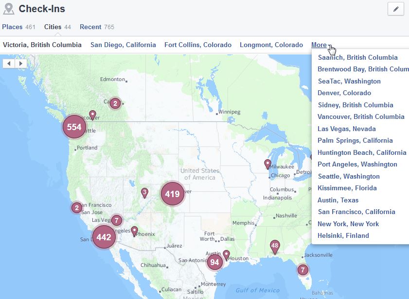
Viewing your facebook checkin history from your facebook profile page
Foursquare History Feeds
The foursquare checkin service makes available data feeds which can be handy for mashing up or sharing. Foursquare also notes that The iCal (ICS) and Google Calendar formats are especially nice for importing and displaying your entire Foursquare check-in history in your Calendar on your computer. Feeds are made available in RSS, KML, ICS, and GCAL formats. To access from a web browser simply login to your account and jump to https://foursquare.com/feeds/

The map above shows a glimpse of my foursquare checkin history, retrieved via KML feed and connected to CartoDB for display – pretty simple!
Of interest, about a year ago (or more) I setup an automatic push of my Swarm checkin data (recall foursquare spun off their checkin service into the Swarm app) to a Google spreadsheet. This wasn’t something provided via Foursquare/Swarm settings, however, it was possible to do using IFTTT. Creating a recipe was simple, I cooked up a setting that would detect a Foursquare checkin and then push the data to a Google spreadsheet. The result is a detailed history in XLS format of all my checkin data – ideal for use in a mashup at some later time!
 Cook up an IFTTT recipe to archive your location history from Foursquare!
Flickr Photo history
Sharing photos via Flickr is an awesome way to archive and share photos, I’ve been using the service almost since Day 1. The now free service provides a great way to easily upload photos over mobile while it is also to have a backup of your photos hosted in the cloud. Flickr makes it a little tricky to locate your feed, however, it really is there! Go to your Photostream, then click “More” (far right), then click “Edit” first option. Scroll to the bottom of the page and you should see links to your data feeds displayed, along with the familiar orange RSS icon. Of particular interest, the feeds are available as GeoRSS (geofeed) and KML. These feeds will enable you to visualize your geotagged photos within any map service that supports these data formats.
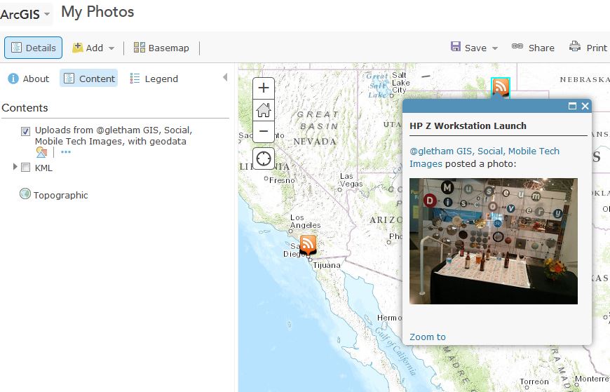
The map above shows a portion of a GeoRSS feed ingested by ArcGIS Online and displayed on the map
Google Location history
If you use google services then you likely have a location history stored by Google – don’t worry though, only you can see it! By accessing your history you can view all the places you’ve been (while location sharing was enabled on your device). You may also be able to view routes you’ve traveled and much more. If you use an Android device you may have automatically received messages from Google on a daily basis telling you about a commute time and delivered to you at a very timely moment (like before leaving for work in the morning). This is enabled by your location history and Google detecting daily patterns or your movements. Google does allow you to view your history, delete it, or turn it on or off. Note, if you don’t mind Google knowing more about you and you want even more useful data served to you about specific locations then use the Google G+ Checkin feature via mobile for your favorite places!

Access your location history by logging in and jumping to https://maps.google.com/locationhistory/
Twitter Location history
For you Tweeters, Twitter also enables users to attach location to Tweets – this is ideally suitable for those tweeting via mobile. It may be a little tricky for some. To enable this you will need to have location or GPS services enabled on your smartphone. Then you will need to alter your Twitter security settings to include location data (you can turn it on or off any time you like and you can also remove your location data later if needed). To remove your location data from displaying in your previous Tweets, including Tweets posted from mobile devices, you can either:
- Delete a particular Tweet that has the location data attached; or
- Remove location data from displaying in all of your Tweets. To do this:
- Log in to your account on twitter.com.
- Go to your Security and privacy settings.
- Under Privacy, look for Tweet location.
- Click Delete all location information. Please note: this can take up to 30 minutes to complete

What I do like about sharing location via Twitter is that the setting can be set to be generalized if you desire. For example, rather than sharing your precise position or address, you can simply add the name of the town or city. Sadly, I have yet to locate how to download or retrieve a complete archive of my location history from Twitter – any ideas?? But, you can download your entire twitter data history from the Analytics service. To use this simply login to Twitter from a PC, then visit https://analytics.twitter.com. On the far right you’ll see an option for “Export Data”
See more in this Twitter help document
iPhone Location history
To be clear, I am no longer an iPhone user (I do have an iPad though). For those of you who opt in to location sharing on your iOS device there are benefits suck as an extensive location history and a service to track your lost device. If you have location services enabled on your iPhone, you can see a map of all the places where you’re iPhone has tracked your location. In addition to viewing a map, you can also see a list of all the places you’ve been. There’s some pretty detailed instructions on how to access and manage these setting in this article.
Finding Location Tagged Data on Social Media with Echosec
Finally, perhaps you’re curious as to what data has been shared at a specific location, at a specific time over social media. Have you accidentally shared data from your home and geotagged it without realizing – I’ve done this before! There’s a fabulous online tool that can help you locate location aware data that has been shared – enter Echosec. Using the service is simple (and free), although to get full functionality you will require the Pro version but this is suitable for hard core users, ideally in law enforcement, military etc… To use Echosec simply zoom into a desired location or type in a place/city name. then you can define an area of interest (like a city block or event venue) and then specify a time range. For example, a favorite use of this for me is to locate a sports venue and then I define my area of interest around the stadium and ask to see posts from a day when there was a big game, like the Super Bowl. You will then be presented with geotagged social media shares from that location – the results are pretty cool, and sometimes shocking! Try it for yourself at htp://echosec.net

Viewing location-aware tweets and Flickr photos on the Echosec Map. The pro version supports hundreds of services!
Summary
I’m a big fan of sharing, and in particular, sharing location aware data. Obviously you need to be careful of what you are sharing and where and when you share it. For those of you who share loads of data, particularly via social media channels, I encourage you to be aware of where and how to access your location data and perhaps you can use these data to mashup with other services and create something that’s cool and useful. When you do, be sure to tell me about it! You can find me on Twitter @gletham
Are you concerned about sharing location aware or geo-tagged data? What concerns you?
You might also enjoy the following articles & Tips: