Thanks to Bill Emison, CEO, Emison Technical Marketing, Ltd. for this special feature submission – In an effort to further expand my knowledge of commercial drone applications, I attended an interesting presentation at the Denver Region Exploration Geologist’s Society (DREGS) meeting, which was held at the Colorado School of Mines in Golden, Colorado on November 2, 2015.
The meeting was held in the historic Berthoud Hall, a beautiful Spanish Colonial Revival style building that was opened in 1940. The audience was a mixture of current Mines students and DREGS members, many of whom are retired natural resource and mineral exploration professionals. I was truly impressed by the amount of “real world” experience present at this meeting and the amazing breadth of knowledge represented by the DREGS membership – what an incredible resource for the Mines’ student body!
The main presentation was titled “GeoDRONEology: The Application of Airborne Robots to Geological Mapping.” The talk was delivered by Ron Bell, a local exploration geophysicist and the principal of Aerobotic Geophysical Systems, LLC (AGS). AGS is a new business that he is developing to automate common field activities that support mineral exploration activities. Mr. Bell’s proposition is simple – airborne robots (Picture 1) are the future of geoscience, and more specifically, geological mapping.

Picture 1: Multi-rotor drone equipped with magnetometer
Consistent with my recent experiences at two (2) unmanned aircraft systems (UAS) conferences, this presentation focused on integrated sensor payloads, rather than the aircraft platform. While this trend is just starting to emerge, it mirrors recent technology shifts in the manned airborne mapping market toward the use of multiple sensors acquiring data simultaneously. This approach allows for more accurate data acquisition, as the operator is able to configure their sensor payload to meet the technical requirements of the project. Furthermore, utilizing a multi-sensor payload is far more efficient to collect data, as it reduces flight times while allowing for immediate exploitation and analysis activities following post-processing activities. This concept is firmly in line with Mr. Bell’s comments about the role of “airborne robots,” where the emphasis is on the data collected, not on the airborne platform used to acquire the data.
One of the most interesting applications cited by Mr. Bell was the use of drones to help locate and identify unexploded ordnance (UXO) in Europe (see Picture 2). This important work can clearly save lives by removing dangerous explosives from the general public, but it also helps ‘reintroduce’ lands for the public good that have been left unused because of the presence of UXOs. In this example, Mr. Bell showed a picture of a small drone equipped with a magnetometer sensor, which is used to locate metallic objects buried beneath the ground. The major advantage of using a drone to locate UXO is the ability to fly VERY low to the ground (< 5 meters), which allows the sensors to pinpoint the location and assess the type of the buried ordnance.
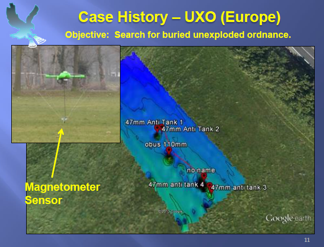
Picture 2: Drone used to locate UXOs in Europe.
Most importantly, Mr. Bell discussed the current capabilities of airborne sensors employed to support geological mapping (surface and subsurface), which include the following services:
- Magnetometry
- Radio EM (Magnetotellurics)
- Color Photogrammetry
- Near Infrared
- Thermal Infrared
His interest (and excitement!) involves the ‘next’ generation of sensors, which are being developed to integrate with unmanned systems. Currently, the UAS market is now seeing both LiDAR and hyperspectral sensor offerings that can directly support geophysical exploration activities. Going forward, there will be sensors to support ground penetrating radar (GPR), gamma ray spectroscopy and electromagnetic interference conductivity (see Picture 3).
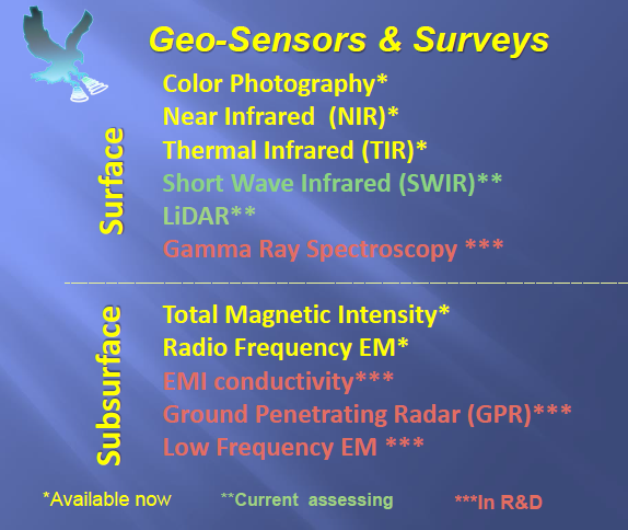
Picture 3: Surface / Subsurface Sensor Capabilities Chart
These new UAS sensors represent an unprecedented movement toward putting the most accurate sensors in the hands of the most knowledgeable scientists and researchers. The ability to customize sensor payloads to meet unique project technical requirements is a sea change for the geophysical world – now geophysicists can plan and execute their own aerial activities to directly support their geophysical research agendas!
The final segment of the presentation discussed the advantages and disadvantages of using drones for geoscience research, the requirements for operating a UAS in the United States and a quick review of the various unmanned aircraft platforms available in the commercial market. For geophysicists, the advantages are clear – field staff are able to collect more samples in a much more efficient manner while significantly reducing worker safety in areas that are difficult to access. In addition, the drones can be programmed to fly at very low altitudes for a relatively low price – a massive improvement over traditional methods of hiring airborne vendors to fly very small project areas (< 10 square miles).
To fully understand the contribution of the different UAS sensors being used to support geologic research, the following graphic (Picture 4) represents that types of data derivatives that can be produced from sensors integrated with a UAS platform. Together, these data can provide a much more comprehensive ‘picture’ of the geologic study area being studied, which provide valuable insights for the researcher!
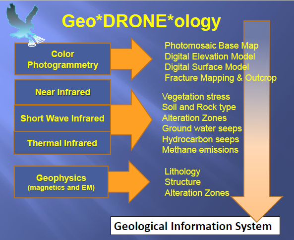
Picture 4: GeoDRONEology Data Derivatives
In summary, the usage of drones to support geologic mapping and mineral exploration activities is poised to increase based on the sensitivity of new sensors and the low cost of data acquisition provided by these unmanned systems. In addition, the ability of drones to be tailored to satisfy various technical requirements provides broad flexibility to support many different research interests. Going forward, I expect many new discoveries over the next few years, as unmanned systems are more broadly utilized by field personnel – an exciting prospect for both the academic and business communities!
Author:
Bill Emison
CEO, Emison Technical Marketing, Ltd.
E-mail: bill@EmisonTech.com
Tel: 303.884.6004
Twitter: @EmisonTech
LinkedIn: www.linkedin.com/in/billemison
Seminar Presenter / Content Contributor:
Ronald S. Bell
President & Consulting Geophysicist
Aerobotic Geophysical Systems, LLC
E-mail: rbell@igsdenver.com
Tel: 720.220.3596