GIS user technology news

News, Business, AI, Technology, IOS, Android, Google, Mobile, GIS, Crypto Currency, Economics

  • Advertising & Sponsored Posts
    • Advertising & Sponsored Posts
    • Submit Press
  • PRESS
    • Submit PR
    • Top Press
    • Business
    • Software
    • Hardware
    • UAV News
    • Mobile Technology
  • FEATURES
    • Around the Web
    • Social Media Features
    • EXPERTS & Guests
    • Tips
    • Infographics
  • Blog
  • Events
  • Shop
  • Tradepubs
  • CAREERS
You are here: Home / Software / Application Story – e-Map Application for Easy Access to Road Data and Images

Application Story – e-Map Application for Easy Access to Road Data and Images

January 14, 2014 By Editor

Scenario

Fujairah Public Works & Agriculture Department is an authority for managing construction and maintenance of all types of roads and Public works information in the Emirates of Fujairah. They employ AutoCAD files as the basic file format to store and manage information about all roads in Fujairah.

In order to effectively solve problems in sharing huge amount of spatial information of Fujairah Public works data in the CAD format to different departments, a system for increased decision support capabilities is needed. For this reason, a comprehensive GIS e-Map system used to store, edit, and share all types of geographic information of roads with improved accuracy of existing information to different offices and users, is recommended to Fujairah government officials for making better decisions.

Fujairah Public Works and Agriculture Department, GIS e-Map
 
Goal

Evolving GeoSystems Technologies, Supergeo’s reseller in United Arab Emirates, created a new transformation model which helps client to integrate input GIS layers extracted from the AutoCAD files with an ERP system to systematically set up and view up to dated huge amount of data. By means of this transformation model, client can easily include new set of data sources to current system architecture and administrator can write advanced query to extract details from ERP system.

The model is fast in response and provides better options to integrate standard Shape files with different ERP systems and other database formats. Since the application is using standard shapefile format, client can use existing proprietary software along with SuperGIS Desktops to edit GIS layers. Additionally, the model helps client schedule a job on specified intervals to update recent changes made in ERP system to the GIS layers. The model provides option to select data structure of output tables without altering existing ERP system tables so that resulting output GIS layers displays only specified details to the web application users.

 
Solutions

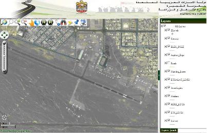
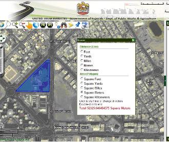
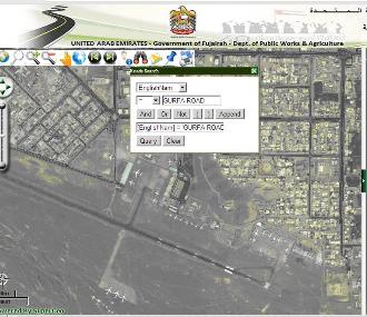
Fujairah Public Works and Agriculture Department, GIS e-Map is a SuperGIS Server web application developed on JavaScript. This application applies the server to publish maps and GIS data. Therefore, public users in Fujairah can use the browsers to view, query, add, and manage the Fujairah data easily.
The system functionalities can be divided into various parts: Basic Map Manipulation, Advanced Query, Reporting and Measurement of features.

(1) Basic Map Manipulation: Fujairah Public Works and Agriculture Department, GIS e-Map Information System provides information about Roads, Contours, telecommunication, and services, and users can use Zoom to Full Extent, Zoom In/Out, Pan and Measure tools to do basic browsing according to their needs.

(2) Advanced Query: This functionality helps the user to create his criteria of searching by choosing the layer, the field, the criteria of search and the output result. The user can zoom to the extent of searched feature with results getting popup on the screen after clicking on the query tool.

(3)Reporting: This functionality helps to export the map information to PDF and user can print the map extent in different scale.

(4)Measurement of Features: User can calculate area and distance of features in different units.

export the map information to PDF
Advanced Query
 
Results

The GIS e-Map web application helps the user to handle huge amount of public works data containing several layers simultaneously. The government officials will get a clear idea about different public work projects in the emirate of Fujairah and they can plan meticulously in the future. The application also provides user restriction to view and edit data based on the type of authentication.

Using the transformation model, administrator can easily include new database tables to current system architecture. The model is fast in response and provides better options to integrate standard Shape files with different ERP systems. As the model is scheduled to run in specific interval, the web application users and decision makers get access to most recent changes made in the database tables.

The application helps Fujairah Public works management to effortlessly plan construction of new roads and renewal of existing roads and can generate reports about different road projects.

Measurement of Features


Filed Under: Software Tagged With: Application Story - e-Map Application for Easy Access to Road Data and Images, Articles, software

Editor’s Picks

LizardTech White Paper Reveals 12 Hidden Gems in GeoExpress Software

Social Guide – The Definitive Starting Point for Mastering your Twitter Analytics

Have Infographics and Data Visualizations Ruined Good Map Design?

Reading – Reduce Your Open Source Security Risk

See More Editor's Picks...

About Editor

Glenn is a geographer and a GIS professional with over 20 years experience in the industry. He's the co-founder of GISuser and several other technology web publications.

Recent Industry News

The Drift Between Early Notes and Final Case Files in Abuse-Related Legal Support

April 29, 2026 By GISuser

Aerial Surveys Int’l and Global Marketing Insights to Present GEOINT 2026 Workshop on Multi-Domain Geospatial Fusion for Automated Infrastructure Monitoring

April 24, 2026 By GISuser

Why Timing Matters More Than You Think With Spray Seal (And Why People Often Get It Slightly Wrong)

April 22, 2026 By GISuser

The Quiet Planning Stage Most People Don’t See When Building a Pool in Brisbane

April 22, 2026 By GISuser

Hot News

State of Data Science Report – AI and Open Source at Work

HERE and AWS Collaborate on New HERE AI Mapping Solutions

Virtual Surveyor Adds Productivity Tools to Mid-Level Smart Drone Surveying Software Plan

Categories

Copyright gletham Communications 2015 - 2026

Go to mobile version