GOLDEN, COLORADO, 11 July 2012 – Golden Software, Inc., the leading provider of affordable scientific graphics software, announces the release of Surfer 11, a powerful, user-friendly software package which accurately transforms data into presentation-ready maps.
Introduced in 1984, Surfer has emerged as the industry standard gridding and contour mapping software used by geologists, hydrologists and engineers. Surfer 11 offers twelve different gridding methods, including Kriging with variograms, to convert irregularly spaced XYZ data into a uniform grid. Display a grid or digital elevation model in one of eight fully customizable 2D and 3D map types: contour, watershed, image, shaded relief, 1-grid and 2-grid vector, 3D wireframe, and 3D surface maps. Enhance the display by adding post, classed post and base maps. Contour and 3D maps generated with Surfer are known for their clarity, vibrancy and accuracy.
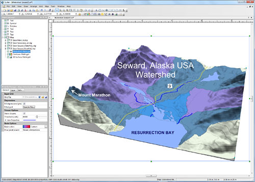
One of the most popular new features in Surfer 11 is the ability to create watershed maps. Users can now load a grid file to create a watershed map and display catchment basins and stream lines based on the Z data in the grid file.
In addition to creating watershed maps, users can now load and label base maps with attributes. This has been a top request from current users. Load features into Surfer with attributes, label the features with the attributes, edit the attributes, and export the feature and attribute information together to a new file.
Three other powerful time-saving upgrades to Surfer 11 are automatic profiles, interactively measuring distance and area, and locking the position of an item on the page. Users can now simply draw a line on a map and a topographical profile is automatically created! Users can also measure lengths and areas by drawing a line or polygon on a map. The length and area measurements are displayed and updated immediately as the user is drawing the item. Locking the position of an item on the page allows users to create their project with the confidence that their maps, legends and items will stay in the exact same spot that they are laid out.
Comments from Surfer 11 Beta Testers:
- “Surfer 11 is great, with many long-desired improvements” – John Vanderlaan, President / Geophysicist, Prism Geoimaging, Inc.
- “I fell out of my chair when I read that you can lock object positions!!!!! Love it. Thank you so much” – William E. Steinhart III, Senior Geophysicist Project Manager, Enviroscan, Inc
Surfer 11 operates in a Microsoft® Windows environment with Windows XP SP2 or higher, Vista, 7, or higher. Surfer 11 is now available for a retail price of $699, with quantity discounts available. Upgrades from previous versions of Surfer are available for only $229. Surfer 11 includes free updates and free technical support. A full User’s Guide is available for only $25.
Visit www.GoldenSoftware.com to download a free Surfer 11 demo and place an order.
About Golden Software:
Founded in 1983, Golden Software is a leading developer of affordable scientific graphics software. Its customer base includes over 100,000 users involved in oil and gas exploration, mining, geosciences, engineering, business, education, and government in 179 countries and territories. Golden Software offers five products in addition to Surfer: Voxler® for 3D data visualization; Grapher™ for 2D and 3D graphing; Strater® for well log, borehole and cross section plotting; MapViewer™ for thematic mapping and spatial analysis; and Didger® for digitizing and coordinate conversion. For additional information, visit www.GoldenSoftware.com or call 303-279-1021.