GIS user technology news

News, Business, AI, Technology, IOS, Android, Google, Mobile, GIS, Crypto Currency, Economics

  • Advertising & Sponsored Posts
    • Advertising & Sponsored Posts
    • Submit Press
  • PRESS
    • Submit PR
    • Top Press
    • Business
    • Software
    • Hardware
    • UAV News
    • Mobile Technology
  • FEATURES
    • Around the Web
    • Social Media Features
    • EXPERTS & Guests
    • Tips
    • Infographics
  • Blog
  • Events
  • Shop
  • Tradepubs
  • CAREERS
You are here: Home / News / GIS, Geo Tech Software / SuperGIS Spatial Analyst 3 Enhances Spatial Modeling and Analysis

SuperGIS Spatial Analyst 3 Enhances Spatial Modeling and Analysis

December 21, 2011 By Editor

SuperGeo Technologies, the leading global provider of complete GIS software and solutions, introduces SuperGIS Spatial Analyst 3, the spatial processing tool working with SuperGIS Desktop 3.1 to complete advanced spatial analyses and tasks.

Designed for deriving information from geo-applications, the newly developed SuperGIS Spatial Analyst 3 provides users with various analysis methods such as geographic attributes and geometry relationship.

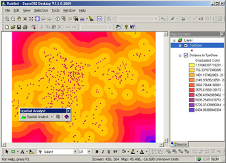
To greatly enhance the operating performance and the precision of data analysis, Spatial Analyst 3 adopts the new development engine and whole new algorithms, which gives users more flexibility and capability to accomplish analysis tasks. This extension tool also includes innovative built-in spatial models, such as Distance Analysis, Interpolation Analysis, Generalization Analysis, and Local Analysis.

With Spatial Analyst 3, users can create, analyze, and query raster data for a wide range of applications, inclusive of terrain hydrology, environmental protection, facility management, medical resource distribution, and infectious disease analysis. According to SuperGeo, the brand new Spatial Analyst is expected to be released in Q1 2012 with better pricing.

For more information about Spatial Analyst 3, please visit http://www.supergeotek.com/Library_1_201112.aspx

Local analysis performs the calculation that each pixel value of the output raster


#  #  #

About SuperGeo
SuperGeo Technologies Inc. is a leading global provider of GIS software and solutions. Since the establishment, SuperGeo has been dedicated to providing state-of-the-art geospatial technologies and comprehensive services for customers around the world. It is our vision to help users utilize geospatial technologies to create a better world.

SuperGeo software and applications have been spread over the world to be the backbone of the world’s mapping and spatial analysis. SuperGeo is the professional GIS vendor, providing GIS-related users with complete GIS solutions for desktop, mobile, server, and Internet platforms. More information about SuperGeo is available at www.supergeotek.com
 

Filed Under: GIS, Geo Tech Software Tagged With: Geo Tech Software, GIS, News, SuperGIS Spatial Analyst 3 Enhances Spatial Modeling and Analysis

Editor’s Picks

Using Lidar to Classify Landslides

Feature: Social Media Mapping is Crucial for Market Research and your Social Strategy

Wider Selection of US Topo Maps From USGS Now Available in Avenza’s PDF Maps App

Real Earth™ Wins Microsoft Competition for 3D Mapping and Localization

See More Editor's Picks...

About Editor

Glenn is a geographer and a GIS professional with over 20 years experience in the industry. He's the co-founder of GISuser and several other technology web publications.

Recent Industry News

Aerial Surveys Int’l and Global Marketing Insights to Present GEOINT 2026 Workshop on Multi-Domain Geospatial Fusion for Automated Infrastructure Monitoring

April 24, 2026 By GISuser

Why Timing Matters More Than You Think With Spray Seal (And Why People Often Get It Slightly Wrong)

April 22, 2026 By GISuser

The Quiet Planning Stage Most People Don’t See When Building a Pool in Brisbane

April 22, 2026 By GISuser

Best Equipment Labels for Industrial Use: Ranked Systems That Survive Real-World Conditions

April 17, 2026 By GISuser

Hot News

State of Data Science Report – AI and Open Source at Work

HERE and AWS Collaborate on New HERE AI Mapping Solutions

Virtual Surveyor Adds Productivity Tools to Mid-Level Smart Drone Surveying Software Plan

Categories

Copyright gletham Communications 2015 - 2026

Go to mobile version