Virginia Tech acquires new data-collection technology to assist Virginia DOT’s public-private highway asset maintenance partnerships
Think of roadways and an image of asphalt or concrete pavement takes center stage in the mind’s eye. It’s easy to overlook the many assets that make roadways intelligent integrated systems: signs, traffic signals, lighting, drainage structures, guardrails, etc. Departments of transportation like Virginia’s don’t overlook these highway assets, though-they’re responsible for protecting the safety of the motoring public by ensuring that the assets are in good operating condition. Obviously, maintaining roadway system assets across vast geographic areas is a daunting task. The fact that state budgets are being squeezed by declining tax revenues does not make this labor-intensive task any easier to justify. Through a partnership with Virginia Tech in Blacksburg, Va., which is utilizing powerful new roadside asset-gathering technology and beginning to build a mobile condition assessment system for monitoring the assets, the Virginia Department of Transportation (VDOT) is trying to do something about this.
Private-public partnership
Dr. Jesus M. de la Garza, the Vecellio Professor in Civil and Environmental Engineering, and graduate assistants Grant Howerton, Dimitris Sideris and Berk Uslu of Virginia Tech’s Vecellio Construction Engineering & Management Program (VCEMP) were laying the groundwork for the assessment system by the spring 2010 semester. Under a new such method of monitoring, vehicles will be driven along highways and collect data for evaluation back at the office-a much more efficient way than having crews evaluate asset condition on foot. The research effort is taking place through the department’s Center for Highway Asset Management Programs (CHAMPS). A key tool in developing the assessment system is the new IP-S2 mobile mapping system from Topcon Positioning Systems (see sidebar). "We have had a very close relationship with VDOT for 22 years-since I’ve been here," said de la Garza. The university has provided continuing education for VDOT personnel for years and de la Garza planted the seeds for CHAMPS more than 10 years ago after kicking around the idea with VDOT leadership over dinner during a workshop one evening. The graduate assistants conduct research for VDOT through CHAMPS at the civil engineering department level, often utilizing a university-level centerpiece of research at Virginia Tech.
The Virginia Smart Road is a full-scale, closed test-bed research facility that is managed by the Virginia Tech Transportation Institute (VTTI)-the school’s largest university-level research center-and owned and maintained by VDOT. It features a two-lane, 2.2-mile-long pavement and infrastructure equipped with 400 electronic sensors and a fiber-optic backbone. Faculty and students conduct research on the Smart Road, a portion of which is equipped with 75 weather-making towers that produce rain, snow, fog and even ice. Other major features are road surveillance; a signalized intersection; the capability to reproduce approximately 95 percent of all lighting situations a driver may encounter on U.S. roads; and 14 experimental pavement systems and 600 pavement designs. From a computer-equipped control center, researchers can observe highway traffic and driver performance both directly and indirectly using surveillance cameras. Studies have been conducted on new pavement markings, new road signs, pedestrian safety and new vehicle headlamps.
"The Smart Road is really a 2.2-mile laboratory," de la Garza observed. "Instead of having a room with microscopes and machines that slice DNA, or maybe concrete-related equipment where you break cylinders, this lab happens to be a 2.2-mile road."
Legislation a boon to partnerships
A development that clinched a different approach to solving transportation problems in Virginia was enactment of the Public-Private Transportation Act (PPTA) of 1995, which allows private entities to enter into agreements to construct, improve, maintain and operate transportation facilities. Private entities can submit to VDOT unsolicited proposals for construction or maintenance work on the state’s transportation facilities. Three months after the bill was signed into law, Virginia Maintenance Services (VMS) was awarded a contract to administer and maintain about 250 miles of Virginia’s interstate highways-about 20 percent of the state’s highways-for five years, renewable for another five.
"That’s a radical, 180-degree shift from the way that VDOT had maintained the interstates," said de la Garza. VDOT said, We’re not going to tell you what to do, let alone how to do it, much less when to do it. If you’re going to own these 250 miles of interstate for 10 years, we’re going to tell you, These are the performance targets that we want to attain with these interstates; this is where you can become innovative."
After a 10-year experiment, the state’s office of the attorney general and the secretary of transportation’s office drafted updated PPTA guidelines in accordance with amendments enacted by the 2005 General Assembly. From that point on, VDOT established the Turnkey Asset Maintenance Services (TAMS) program and now 100 percent of the interstate system in Virginia is being managed under performance-based contracting, adding about 1,000 miles to the previously managed 250-mile pilot project.
Converting to a performance-based system creates an inherent requirement for ongoing evaluation of assets and thus the contractors maintaining them. CHAMPS has served as an objective and impartial third-party administrator for performance assessment. Under the TAMS program, interstate assets in 13 regions of Virginia have received a full inventory and condition assessment via CHAMPS. Additionally, "We developed a framework that enables VDOT to assess the extent to which the contractors are achieving the performance and then compare that performance with the targets," said de la Garza. "We have developed a report card; we’re a university, so we keep grades," he added with a laugh. The need to evaluate contractors’ performance is what inspired the mobile condition assessment system technology. From 2001-2009, CHAMPS researchers have developed GIS-based reports on the condition of highway assets, which can be searched by type and condition.
Dr. de la Garza first learned about the IP-S2 from a fellow faculty member who e-mailed him information about the system. The technology appeared to be a fit for the ambitious development of the assessment system which, to that point, had required faculty and surveyors to drive to the various regions and collect the data, often on foot. Not only is this method labor-intensive, it also puts humans a little too close to traffic for comfort.
"What motivated our research of the IP-S2 is that our process of finding out the condition of the interstate system was labor-intensive," de la Garza said. "The IP-S2 offers the potential of significantly reducing the manpower component of condition assessment. If we can demonstrate that we can drive the van with the IP-S2 at a certain speed and record what’s on the roadside, if our van can move at 65 miles an hour and collect zillions of gigabytes of data, we can then come back to the office and have technicians who can watch film, look for assets and assess the condition of the assets. We will have semi-automated the process of assessing the condition of the assets. It’ll just be a case of watching film instead of having to walk to the site."
Dr. de la Garza views the assessment system development as a two-phase process. "The first step is having people watching film, which we need to do in the initial stages-that’s phase one," he said. "Phase two is having computer programs that can actually find the assets by themselves. Once they find the assets by themselves, they also assess the condition with what we call `machine vision technology.’ We need to create machine vision algorithms to find a sign, for example, and once found, determine if the sign is in good condition or not."
As of the 2010 spring semester, Howerton, Sideris and Uslu had laid the groundwork for phase one and looked forward to the day when phase two becomes a reality.
Mobile assessment system subject of university research
Howerton and Sideris were looking forward to completing their master’s degree studies in May 2010 and beginning their careers in construction management or civil engineering. They were handing off the research baton to Uslu, who plans to pursue doctoral studies and eventually a university-level career in education and research, anticipates completing his Ph.D. in spring 2013.
Howerton, from the Richmond, Va., area, conducted basic research during his graduate studies comparing traditional data-collection methods with that utilizing the IP-S2, both in terms of accuracy and time consumed. He and Sideris, who received his undergraduate degree in civil engineering in Greece, focused their graduate research on an area of transportation engineering studies they found to be often overlooked: the management of low-capital highway assets. "We did some literature review and we found out that low-capital assets have been overlooked to a great extent all throughout the U.S.," said Sideris. "Most contractors and DOTs are involved with making sure that the roadway pavement and bridges work fine, which makes sense-it’s the most important thing; you want to have a safe highway. But on the other hand, although the low-capital assets seem less important, if a sign is not there, this can cause a lot of problems. The highway is actually one system and everything affects everything else. It’s all important."
Uslu, who completed undergraduate studies at the State University of New York and Istanbul Technical University in Turkey, will focus his research on phase two of assessment system development: automating the collection of highway asset data as well as the monitoring. "I’m planning to come up with some algorithms or ways to make sense of the picture and laser data," Uslu said. "For example, if we drive by and collect the data, we can load the data into a program and the algorithm can detect the asset and evaluate its condition. When it is driven by a sign, the phase two technology will first detect the presence of the sign and fail it if damaged."
The assessment system will not only display the assets, it will also notify VDOT personnel that the asset meets or falls short of predetermined working condition parameters. A given sign might have a certain percentage of its surface covered with mud and may or may not be considered in working order. Uslu adds that he will likely collaborate with researchers at the Center for Human-Computer Interaction for programming these algorithms. An assessment system that fulfills the CHAMPS vision will provide "a huge cost savings for VDOT because 70, 80 percent of the cost of these maintenance programs is collecting the data, which means sending people out," said Uslu. "It’s pretty labor-intensive and there are some human mistakes, of course, when you’re collecting the data."
CHAMPS received the IP-S2 around the start of the fall 2009 semester. Richard Rybka, Topcon mobile mapping specialist, provided support via phone and e-mail as the students set up the system. A van was rented from the Fleet Services Department at the university and a special roof rack was built for mounting the IP-S2. The unit also has a custom-designed hood, required by Virginia Tech to comply with international security regulations affecting the inertial measurement unit system component, which takes several minutes to install and remove. Several connections between the unit, vehicle, and laptop computer allow data collection while driving.
Building the model
By the end of the spring 2010 semester, the IP-S2 had been utilized to collect asset data more than 20 times. While the van moves along the Smart Road or any highway, the four technologies collect data in a 360-degree radius surrounding the vehicle; the distance away from the vehicle at which data are collected is controlled by settings. The students normally set the distance at 10 meters, although the distance can be set as far as 30 meters.
While Howerton drove the van, Sideris viewed the screen of the laptop computer to ensure that the IP-S2 was collecting the data in transit. The laptop uses a Web browser to communicate with the IP-S2 via an Ethernet cable; data collection does not require an Internet connection. The students note that the real fun begins when they integrate the data from the different system components during Geoclean processing. Five operations are performed in Geoclean: processing raw data from the IP-S2 for subsequent operations; Inertial post-processing to create a geospatial vehicle trajectory; generating the LiDAR (Light Detection and Ranging) point cloud; converting compressed image files from the Ladybug camera; and registering the digital image sets to the trajectory and point cloud.
In the lab, Sideris performed the sequential upload. Howerton explained that the students often adjust the settings in Ladybug CapPro software in order to get the best view: panning, zooming, etc., using software from Point Grey Research, manufacturer of the camera. "The settings we use are 18 frames for every tenth of a mile," he said. "That’s actually pretty helpful when, say, you’re looking to analyze the data and you know there are 18 frames."
A key software program used to view, analyze, and extract features from the processed data is Spatial Factory, which merges the imagery and point cloud data "layers." "You see these bubbles?" Sideris interjected. "These bubbles are the photographic data from the Ladybug." Sideris then clicked on one of the bubbles and an image of a Smart Road section appeared on the screen. He then panned the image in a 360-degree radius around the van, virtually putting himself back onto the Smart Road. It is possible to access GPS coordinates so that clicking on a LiDAR point on the model reveals X, Y and Z coordinates, Howerton added.
The point-cloud data layer allows the students to incorporate feature data such as topography and reflectivity of pavement markings into the GIS model. This additional information is revealed on top of the underlying image. "If you have an excavation, a cut and fill project, you can get the dimensions of the current geography and upload it to any computer-aided design software that can process point cloud data and compare it to the design that you have and then you can get the cut and fill exact," Uslu noted.
|
Like Digital Flypaper The mobile mapping system that Virginia Tech’s Center for Highway Asset Management Programs (CHAMPS) is using to help the Virginia Department of Transportation (VDOT) monitor low-capital highway assets works sort of like flypaper with five different adhesives-except that it snags the geospatial data and images of everything near it, not the physical objects themselves. Topcon Positioning Systems’ IP-S2 incorporates three redundant positioning technologies with 360-degree digital imaging and laser scanners. The system consists of a dual-frequency, dual-constellation Global Navigation Satellite System (GNSS) receiver that establishes the geospatial position of the vehicle; an inertial measurement unit (IMU) that tracks vehicle attitude (pose); and external wheel encoders that capture odometry data from the vehicle. Integration of these technologies creates a three-dimensional position for the vehicle and provides accurate tracking in challenging or denied GNSS environments. A high-resolution digital camera provides 360-degree images. The system records and time-stamps inputs at the rate of 15 nanoseconds. Referencing the vehicle location data, the system can capture data from the highway assets. The IP-S2 also uses 3D laser scanners with an effective range of 30 meters. Every second, the scanners collect 45,000 x, y and z points that are used to obtain accurate geospatial positions for assets. Traditionally, Light Detection and Ranging (LiDAR) data have been collected from the air; because this system collects the data from ground level, it provides critical data that cannot be obtained from aerial surveys. |
About the Author
Don Talend of Write Results Inc., West Dundee, IL, is a print and e-content developer specializing in covering technology and innovation.
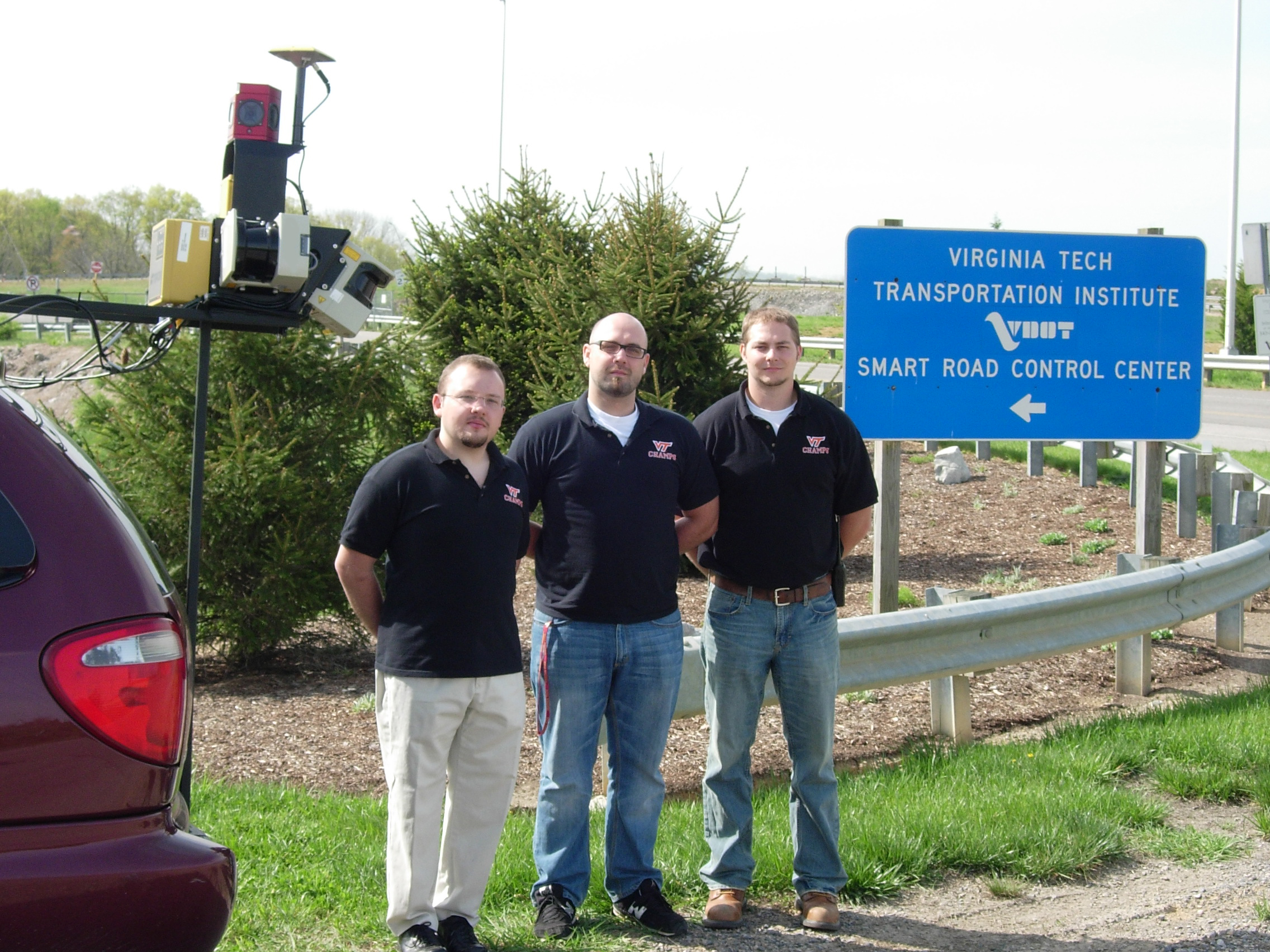
Civil engineering graduate students (L-R) Berk Uslu, Dimitris Sideris and Grant Howerton utilized Topcon’s IP-S2 mobile mapping system to begin building a highway asset maintenance condition assessment system for the Virginia Department of Transportation during the spring 2010 semester. [credit] Don Talend
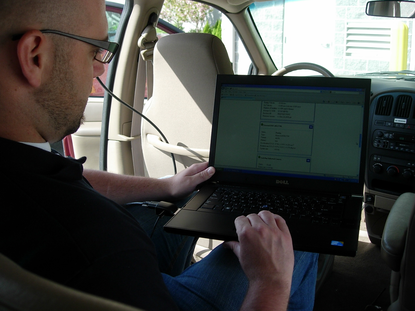
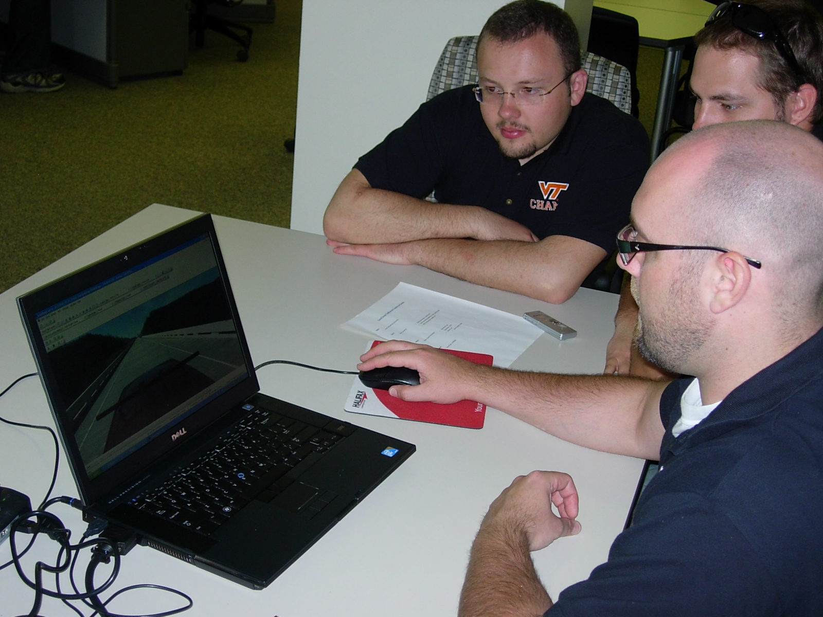
Dimitris Sideris prepares the dedicated laptop computer to receive data from the IP-S2 prior to a collection run on Virginia Tech’s Smart Road. [credit] Don Talend
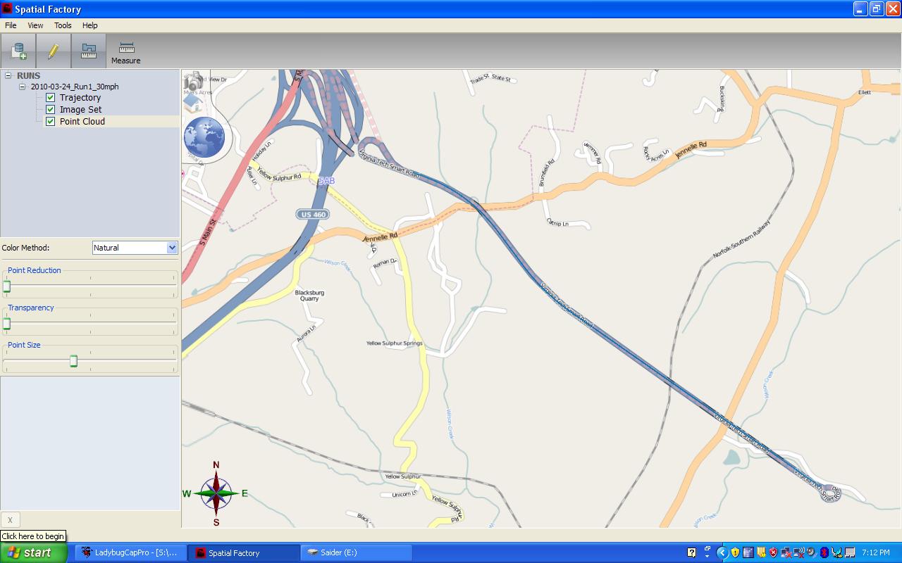
The user can click several points along the highway and view actual images of the assets in a 360-degree radius from the vehicle carrying the IP-S2 system.
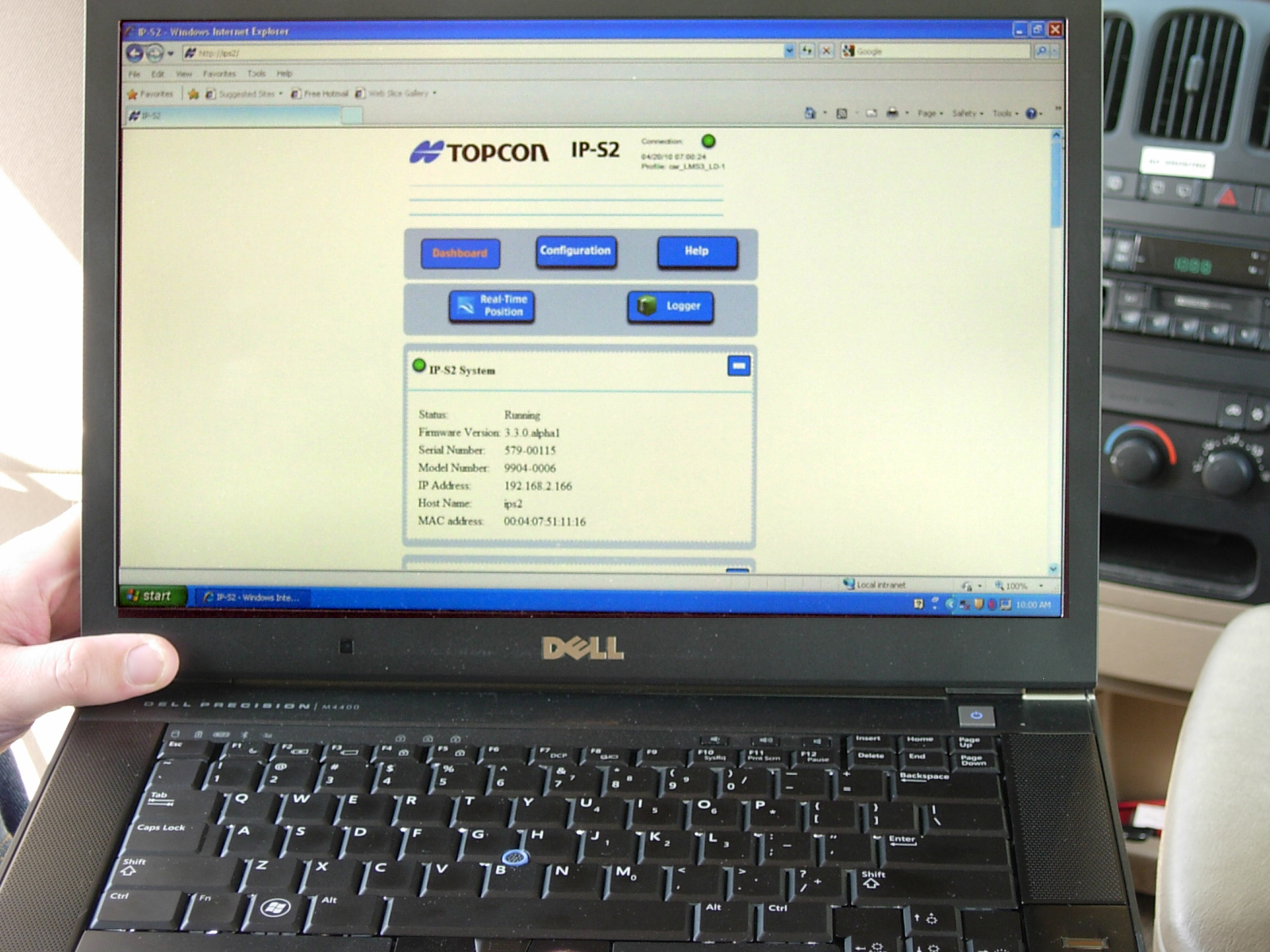
The IP-S2 utilizes a Web browser; an Internet connection is not necessary during data collection. [credit] Don Talend
Dimitris Sideris displays video of a Smart Road data run following a data upload to Spatial Factory software. [credit] Don Talend