 Geographic intelligence is inherently distributed and loosely integrated. Rarely are all the necessary information sets present in a single database instance with a single data schema. GIS users count on one another for portions of their GIS data. GIS Networks enable users to connect to one another and to share their geographic knowledge.
Key web nodes called GIS portals can be implemented that enable GIS users to register as well as to discover geographic information services for access and use. As a consequence, GIS’s are becoming increasingly connected on the World Wide Web for information sharing and use.
Federated GIS
GIS users need more than central systems. They rely on one another for information sharing and collaboration. In the past few years, users have begun to interoperate across the web using GIS web services – primarily for data sharing and web publishing. GIS Web Services have become ubiquitous. Many user communities are establishing formal frameworks and encourage participation in state, national, and global spatial data infrastructures (NSDI’s and GSDI’s) – loose federations of GIS users that share content and GIS processing logic through central GIS portals on the World Wide Web.

Assembling an SDI portal involves three key parts:
- The Catalog Registry and Search Portal
- Dynamic mapping and data fusion on the Internet
- Data modeling and data download to acquire data in a useable and well-documented format for use.
By necessity, these are quickly becoming a key part in many GIS implementations. The goal of this paper is to identify some related GIS trends and to describe some of the technical requirements for new GIS capabilities to support GIS Portals.
GIS is evolving
The primary focus of GIS professionals has traditionally involved intensive efforts to author, compile, and organize bits of geographic knowledge.
In the previous two decades, GIS professionals concentrated primarily on data compilation and focused projects, spending a majority of their time creating GIS databases and authoring geographic knowledge. Throughout the 1990’s, GIS professionals began to use and exploit these knowledge collections in numerous GIS applications and settings. Users applied comprehensive GIS tools to compile geographic datasets, build workflows for data compilation and quality control, author maps and analytical models, and to document their work and methods.
This reinforced the traditional view of a GIS a user with a professional scientific workstation that connects to datasets and databases. The workstation had a comprehensive GIS application, with advanced GIS logic and tools that are used to accomplish almost any GIS task.
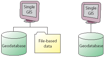
This concept of a GIS software seat has proven invaluable and is widely adopted by GIS professionals in close to 200,000 organizations worldwide. In fact, this client-server computing model has been so successful that many only think of GIS within this context. However, the GIS vision is expanding.
Furthermore, GIS has been continuously evolving from a database approach to a knowledge approach. This has a number of implications that affect GIS data management as well as the GIS computing platforms. Both are undergoing significant change.
GIS Information Management
GIS information management shares many of the same concepts and characteristics with standard Information Technology (IT) architectures and can work well in centralized, enterprise-computing environments. For example, GIS datasets can be managed in relational databases, just like other enterprise information. Advanced application logic is used to operate on the data stored in the RDBMS. Like other transactional enterprise information, GIS’s are used to manage constant change and updates in geographic databases. However, a GIS differs in a number of critical aspects.
GIS data is complex. GIS data volumes are quite large in the number and size of elements. For example, a simple database query to populate a common business form delivers a few rows of data from the DBMS while a map draw will require a database query that returns hundreds, and even thousands of records. In addition, the vector or raster geometry being retrieved for display can be many megabytes and larger in size for each record. GIS data also has complex relationships and structures, such as networks, terrains, and topologies.
GIS data compilation is an advanced, specialized activity. Comprehensive editing applications are required to graphically build and maintain GIS datasets. Specialized processing, along with geographic rules and commands, are necessary to maintain the integrity and behavior of geographic features and rasters. Hence, GIS data compilation is expensive. This is one of the compelling reasons why users often share GIS datasets.
A Geographic Information System is transactional
As in other database management systems, numerous data updates are constantly being made to a GIS database. So GIS databases, like other databases, must support update transactions. However, GIS users have some specialized transactional requirements. The main concept underlying this is often referred to as a long transaction.
Examples of long GIS data transaction workflows include:
– Disconnected editing. Some users need the ability to “check out” portions of the GIS database and to replicate it at another location in an independent, standalone system. For example for field editing: Tear off some data, take it into the field to perform edits and updates, and then post the changes to the main database.
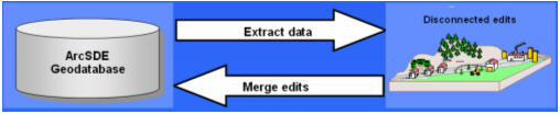
Disconnected editing
– Distributed geographic databases. A regional database may be a partial copy for a particular geographic region of the main corporate GIS database. Periodically, the two databases must be synchronized by exchanging updates between them.
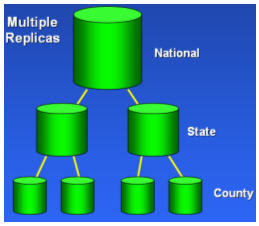
Loosely-couple replication
– History management. Some users need to maintain retired versions of updated features. For example, what was the state of the land parcels on January 1, 2004?
GIS is inherently a distributed information system
Today, there is widespread recognition that the data layers and tables in most geographic information systems come from multiple organizations. Each GIS organization develops some, but not all, of its data content. At least some of the layers come from outside of the organization. The necessity for data drives users to acquire their data in the most effective and timely manner, including acquiring portions of their GIS databases from other GIS users.
Thus, GIS data management is distributed among many users.
Interoperability. The distributed nature of GIS has many implications on interoperability between multiple GIS organizations and systems. Collaboration among GIS users is crucial.
GIS users have long relied on collaborative efforts for data sharing and use. Recent trends and efforts on GIS standards reflect this fundamental need. Adherence to industry standards and commonly adopted GIS practices will be critical to the success of any GIS. GIS must support critical standards and be able to adapt and evolve support as new standards emerge. This is essential.
GIS Networks
A GIS Network is an implementation of a federation of GIS’s that are interconnected in a loosely-coupled way using the World Wide Web. It is a constellation of user sites that publish, discover, and use shared geographic information. Many geographic datasets can be compiled and managed as a generic information resource and shared among a community of users.
Key web nodes called GIS Portals can be implemented that enable GIS users to register as well as to discover geographic information for access and use.
Components in a GIS Network. A GIS Network has three key building blocks:
– GIS Catalog Portals, where users can search for and find GIS information and services relevant for their needs.
– GIS nodes where users compile and publish GIS information sets, applications, and GIS web services.
– GIS users who search for, find, and then connect to and use published GIS data and services.
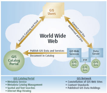
The three key building blocks in a GIS Network
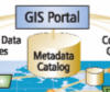
GIS Catalog Portals. A key component in any GIS Network is a GIS catalog portal with a registry of the numerous data holdings, information sets, and services. A number of GIS users compile and publish their datasets for shared use by other organizations. They register their information sets at the catalog portal. By searching a catalog portal, other GIS users can find and connect to desired information services.
The GIS catalog portal is a website where GIS users can search for and find GIS information relevant to their needs. The Portal is the catalog referencing a federated network of published GIS data services, map services, and metadata services.
A GIS catalog can reference data holdings contained at its site as well as at other sites. Periodically, a GIS catalog portal site can harvest catalogs from a constellation of participating sites and publish one central GIS catalog.
It is envisioned that a series of catalog nodes will be available to form a network—a Spatial Data Infrastructure.
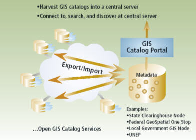
GIS data and services from numerous sites can be collated into a central GIS catalog portal that can be searched to find candidate information sets for use in various GIS applications.
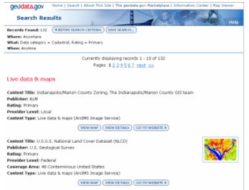
One example of a GIS Catalog Portal is the U.S. Government’s Geospatial One-Stop Portal (www.geodata.gov). This portal makes it easier, faster and less expensive for all levels of government and the public to access geographic information.
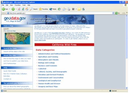
Geodata.gov is a key node in the United State’s National Spatial Data Infrastructure (NSDI).
Functions of a GIS Portal
GIS catalog portal users can do the following: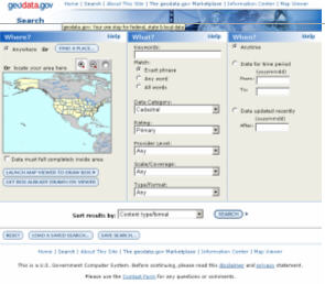 Search Form
· Search a GIS catalog portal for image and feature Web services, images, geographic data sets, contacts, activities, and clearinghouses.
· Search GIS metadata catalogs in real time.
· Set geographic search boundaries or use a graphic selection tool to define a search area.
Search Results
· Search criteria can be based on content type, such as Web map services, geographic data sets, a data theme, or an attribute value range.
· Search results are displayed with metadata about the product and a map, if appropriate
· Save search criteria in a favorites section, which is enabled by the user account information.
· Register for notification when new or updated data, such as, maps, activities, and references, has been added to a GIS network that occur in a favorite search area.
· View metadata records to determine if a candidate data set is suitable for the intended use.
· Access and view geographic data and Web services directly through a GIS Catalog Portal when available. Maps can be viewed in the Web browser or with GIS software to display multiple data sources along with data from local sources.
· Download geographic data from providers through feature streaming or FTP services for large data sets.
· Publish (register) map services, images, geographic data sets, geoservices, spatial solutions, geographic and land reference material, and geographic activities or events to share with others through submission of online forms within a GIS Catalog Portal. Data providers will have the ability to update their metadata submissions.
Catalog Management Functions
GIS Catalogs Are Like Card Catalog Databases in Libraries
The information holdings in a GIS include a broad range of data types in various media. Each should be documented, indexed, and cataloged for searching and sharing. For example, GIS holdings can include static and interactive maps, map layers, applications, analytical models (e.g., geoprocessing scripts), reports, data sets and databases, GIS Web services, and much more. Each of these items can be documented using standards-based metadata. The catalog is an ordered collection (i.e., a database) of these documents and serves the same purpose as the card catalog in a library. In an enterprise or departmental GIS, the GIS catalog can be more than simply metadata documentation about published data sets. It can also be the data dictionary for an organization and can help organize all of the information sets and results produced by a GIS.
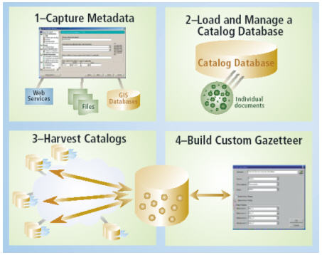
Some of the common GIS tasks for building and maintaining a central metadata catalog portal that is used for GIS data discovery and access. Building and maintaining GIS Catalog Portals is increasing as a standard enterprise GIS activity, especially for government GIS’s.
Dynamic Mapping and Data Fusion on the Internet
As GIS continues to grow, many users will access GIS through their web browser and other low-end appliances. In enterprise GIS’s and in SDI’s, many users access GIS information through dynamic mapping applications that run inside the user’s web browser. These dynamic HTML applications can provide highly functional mapping functions to many users. These will be the GIS map dashboards for many users to interact with and work with the GIS.
Dynamic applications can fuse data from many GIS websites into a single view and provide focused tools to work with the data–to perform focused analysis and, in some cases, even to perform simple updates to a central GIS database.
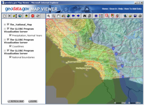
The dynamic Map Viewer at the www.geodata.gov website enables users to simultaneously access and use numerous web mapping services and data feeds.
Data Modeling and Common Content Standards
Interoperability between and among the various GIS nodes in a GIS network requires that each GIS database adheres to a similar essential data model based on widely adopted best GIS practices. GIS tools can be used to create and share these data models. The resulting data sets can share common content across organizations using a SDI.
As envisioned, building and maintaining the feature and raster datasets for a SDI will be a collaborative effort by numerous organizations. Certainly the content and structure of each user’s GIS database will vary somewhat from participant to participant. However, some level of data standardization will be critical for building nationally consistent data layers. The role of common GIS data models will be essential. Additional steps will be necessary for participants to agree on a minimum set of essential data model characteristics. Such a collaborative design must be expressed and built by the participants.
• Common spatial representations: There should be commonly agreed-upon feature and image representations (e.g., local roads at 1:24,000 scale shall be represented as lines).
• Common terminology and names. GIS users will begin to use common naming conventions when describing their geographic features and datasets.
• Common data collection goals. Users will need to define their goals for data collection for each dataset. For example, does this stream’s dataset identify all of the drainage lines in the area or only a sampling of the drainage network? These are critical data collection characteristics that must be documented for each dataset in order to determine appropriate uses of the data. More importantly, users will need to agree to some common goals in order to build accurate, seamless coverages for larger jurisdictions (e.g., for mosaiced datasets that cross map sheet boundaries, states, counties, and so on.
• There should be an essential set of data integrity rules defining feature relationships and behavior with each data set. For example, road lines as well as hydrology and contour lines must connect at endpoints and not self-overlap; connected contour lines must have consistent elevations; county boundaries (and similar administrative units) cannot overlap one another and must nest within state boundaries.
• Classifications, such as road class and land-use/land-cover classifications, must be documented and consistently stored. While not essential, adoption of common classifications can simplify interoperability implementation.
• The data model must include the definition of standard map products and scales associated with a data model specification. A common cartographic standard for map sheets, symbols, and label specifications will be important.
• A common metadata description (adhering to Federal Geographic Data Committee [FGDC] or other standards) for key layers of information is essential for the consistent discovery of SDI information sets across thousands of organizations. While every dataset covers its particular geography, common data layers should be consistently described among the participating organizations. Each dataset’s adherence to a specific data model guideline should also be noted (e.g., a common hydrology data model).
Standards Support
A GIS Portal must be able to support relevant GIS and IT standards as well as to work with the numerous data types and formats applied by GIS users.
Data Formats. A fundamental principal of geographic information systems is the concept of data integration (e.g., spatially integrating different datasets for visual and analytical purposes). This involves integrating various map or thematic layers of information often originating from different organizations and disciplines and in many formats.
For example, it is quite common for GIS users to access and use vector features in many formats, raster imagery, CAD drawings, tables, survey and COGO measurements, GPS observations, linear referencing systems, and government profiles such as TIGER, GML, SDTS, and ATKIS.
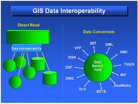
It is critical that the GIS has a common framework for simultaneously accessing and working with the widest possible range of information sources using files, databases, and web services.
Protocols and Standards for GIS Portals. A number of content standards and web services protocols have been developed to support GIS Networks. These include:
- Metadata content standards from the U.S. government (FGDC), ISO, EEU, ANZLIC, and other organizations. These define the metadata contents that are recorded in documents for GIS datasets. Each is an extension of general catalog standards such as Dublin Core.
- Web Services protocols from OGC, W3C, and other organizations.
The main focus for web services has been on the use of XML and the definition of particular XML protocols. Over the past decade, many organizations defined the own XML protocol. For example, ESRI designed and published its open ArcXML specification. Since then, the general computing industry has agreed upon and is adopting numerous XML protocols (e.g., SOAP for XML messaging).
The Open GIS Consortium (OGC) has focused on development of a series of interoperability specifications for GIS. These include:
- WMS (Web Map Service)
- WFS (Web Feature Service, basically for GML delivery)
- WCS (Web Coverage Service, a type of raster data service referred to as a “coverage” that is more or less a subset of WMS for data delivery instead of map pictures.) The OCG “coverage” should not be confused with the traditional ArcInfo Coverage vector data model that was first developed and released in 1980)
- Catalog Interface (Discovery, access, and query for catalog servers)
- Numerous others
For more information, see http://www.opengis.org/specs/.
Support for these and other standards is critical for successful GIS Portal implementation.
Summary
The long-held notion of a GIS as a closed, proprietary system is no longer true. Geographic information is now widely distributed on the web and routinely integrated into thousands of applications and services. Over the past several years, GIS portals and networks are one of the fastest growing areas in GIS. Federated systems will continue to proliferate.
Over time, we envision that portals will become much more than centralized access to information. Portals will begin to provide a dashboard for application access and use as well as to distribute the update and maintenance of shared databases.
About the Author
Clint Brown Director, Software Products Environmental Systems Research Institute, Inc. (ESRI)
Joined ESRI in 1983.
Responsible for managing ESRI product releases, including ArcInfo, PC ArcInfo, ArcView, ArcSDE, ArcCAD, MapObjects, ArcGIS, ArcIMS, and other ESRI software. Clint’s teams work closely with Software Development teams managed by Scott Morehouse, ESRI’s Chief Software Architect and Visionary.
Presents talks on GIS implementation and concepts at numerous conferences and meetings annually. Also has authored portions of several books, white papers, and presentations on GIS, including significant contributions on many ESRI Press books, ArcNews, ESRI Training, and software user guides.
GISuser.com would like to extend their thanks and appreciation to Clint Borwn and ESRI for taking the time to provide our readers with this interesting article.
