 The GADDS system provides geophysical data products including; magnetic, radiometric, gravity and digital elevation data from Geoscience Australia’s geophysical data archives. The data are free to download and many are also available for delivery on CD-ROm as well.
Most recent addition to the archive – GEODATA 9 Second DEM Version
GEODATA 9 Second DEM is a gridded digital elevation model derived from topographic information that includes point elevation data, elevation contours, stream lines and cliff lines. The grid spacing is 9 seconds in longitude and latitude (approximately 250 metres). DEM data available for download are in ER Mapper (ERS) format.
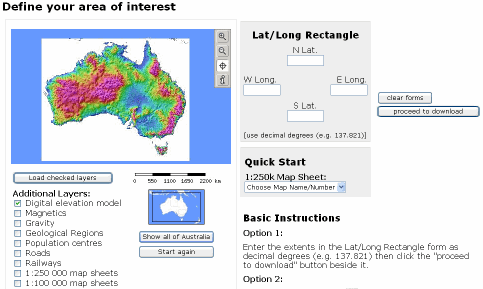
The system is presented using a nifty webmapping interface. Users can specify bounding coordinates, define a rectangle for the area of interest, or select from a number of predefined map sheets.
Avaialble data layers for display include:
Digital elevation model
Magnetics
Gravity
Geological Regions
Population centres
Roads
Railways
1:250 000 map sheets
1:100 000 map sheets