
Automation to Enhance Feature Extraction, Change Detection on the UP42 Platform
UP42 Announces Thetaspace as Copernicus Masters Challenge Winner with Solution to Cloud Cover in EO Data
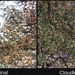
CloudlessEO Algorithm Fills in Clouds and Shadows in Optical Satellite Imagery
UP42 Unveils Very High-Resolution Imagery from Airbus Pléiades Neo Satellites

Enhancing Applications in Utilities, Insurance, Agriculture, Government
UP42 Unveils Very High-Resolution Imagery from Airbus Pléiades Neo Satellites

Enhancing Applications in Utilities, Insurance, Agriculture, Government
UP42 Teams with HEAD Aerospace to Bring Diverse Image Data to Geospatial Marketplace, Expanding Applications in Multiple Sectors

Deal makes data from 40 Chinese satellites available through UP42 now, another 40 by late 2021
UP42 Teams with Deutsche Gesellschaft für Internationale Zusammenarbeit (GIZ) GmbH to Support Agricultural Start-Ups in Africa

Strategic Collaboration to Empower Smallholder Farms with Geospatial Tech
UP42 Expands Optical and SAR Data Offering with SI Imaging Services of Korea

UP42 and SIIS agreement makes KOMPSAT satellite imagery available on the marketplace
UP42 Announces Copernicus Masters Challenge to Augment Earth Observation Data with Generative Adversarial Networks
The global innovation competition will award the best algorithms that address challenges in EO analytics
UP42 to Offer Smart Satellite Data from Australia’s LatConnect 60 on the UP42 Geospatial Marketplace

BERLIN, Germany, 15 December 2020 – UP42 today announced that image data and information from the planned LatConnect 60 constellation of mid-inclined orbit remote sensing satellites will be available on the UP42 developer platform for Earth observation data and analytics.
UP42 Hosts Webinar on Fusion of Satellite Imagery, AIS Data, Machine Learning for Maritime Surveillance
BERLIN, Germany, 30 November 2020 – UP42, creator of the leading developer platform for Earth observation data and analytics, will host a free webinar on maritime monitoring and surveillance on Dec. 9, 2020. Presentations will discuss the integration of optical and radar satellite imagery with Automatic Identification System (AIS) ship tracking data for analysis using machine […]